Pine Creek, Northern Territory
The Wagiman, Jawoyn Bolmo, Matjba and Wurrkbarbar groups are the traditional owners of this area and, since 2019, they have held exclusive Native Title rights over this land.
In 2005 a prominent resident of Pine Creek, Edward Ah Toy, was recognised as the Northern Territorian of the year.
History
Pine Creek is one of the oldest towns in the Northern Territory and it is named for the pine trees that once grew by the creek in the centre of the town and although it was originally and officially called Playford, it was never known by this name and it was officially changed to Pine Creek on 20 September 1973. Of the name SW Herbert wrote:
"We setled down in our new camp at Pine Creek, since well known throughout Australia, first on account of its being a rich gold field, and years later as the inland terminus of our only railway on the north coast. This creek is by no means large, but was remarkable for pines growing there, thus the name of Pine Creek.".
— SW Herbert, Reminiscences of life in the Northern Territory: 1870-1873
By 1875 there were two hotels, The Royal Mail and The Standard, competing for business. A public school opened in the town in 1899. By the 1890s, up to 15 mines were operating in the area, and the town's population exceeded 3000 people.
The towns population fluctuated significantly in its early years and declined significantly in the interwar period; one of the few developments in this period was the establishment of the short lived Pine Creek Home between 1931 - 1933; it was briefly reopened in the early war years 1940 - 1941 as a place were children who were being transferred from government institutions to church missions.
Mining
Immediately after the construction of the Overland Telegraph Line in 1872 gold was discovered at the Eleanour Reef at Pine Creek by Wentworth D'Arcy Uhr. There is an alternative story in which it was Darwent & Dalwood who found gold while digging holes for the telegraph line and that the government did not wish to publicise the discovery as they did not want the 'distraction' of a gold rush, despite this, the discovery by Uhr is the more widely accepted version. News of this discovery spread quickly and, by January 1873, 23 mining claims had been taken up and resulted in the creation of the township. It was here that the Northern Territory's first stamp battery was constructed in July 1873.
Chinese miners, mostly from the Kwangtung Province, began arriving in Pine Creek in 1874 and 176 of these were indentured by the South Australian government. In 1877, following the discovery of substantial alluvial gold deposits they began arriving in great numbers. In 1879 a Chinatown was established and the population reached its peak of 900 people. However, this mining boom was short-lived as, by 1882, only 80 miners remained and by 1886 it was virtually inactive.
The boom restarted following the completion of the North Australia Railway to the area in 1889 when many of the Chinese laborers who had been employed on its construction, approximately 3,000 in total, settled in Pine Creek; this included Ah Hong who remained there for a short time. The population of the town in 1894 was 753 Chinese people and 39 'Europeans'. The Chinese migrants, like Aboriginal people, suffered experiences of racism but the traffic of opium, the impact of intensive mining and unequal relationships with Aboriginal women (in which many men did not claim their paternity of children) are methods that parallel with European impacts on Aboriginal people's lives.
There was a cycle of economic growth and decline at Pine Creek but, by 1915. approximately 75,000 ounces (over 2,000 kgs) of gold had been mined there. There is evidence of a thriving Chinese community at Pine Creek until the late 1920s, during The Great Depression which was, soon after, followed by the evacuation of the entire civilian population during World War II and following the Bombing of Darwin and production ceased.
Mining began again, near the town, between 1967 and 1974 where iron ore was mined at Frances Creek, about 25 kilometres north. During this time approximately 6 million tonnes of ore were extracted. In June 2007, Territory Resources (trading under the name Territory Iron) commenced mining iron ore and gold there. In October 2014, the mine was used for filming an episode of the BBC television program Top Gear. The mine ceased operations in January 2015, after a drop in the price of iron ore, leading to the departure of many local employees. In April 2020, it was announced that mining would resume in May 2020, after a 5-year hiatus.
Also, in 1985, Pine Creek Goldfields Limited opened an open-cut gold mine adjacent to the town, on the site of an old shaft mine. Over a ten-year period, it yielded 764,000 ounces (21,700 kg) of gold. Since closure, its main pit has been filled with water to prevent acid build-up. A lookout is located at the south-western end of Moule Street.
North Australia Railway
The first stage of the lightly built narrow-gauge North Australia Railway was built between Port Darwin and Pine Creek, reaching the town in 1889. Additional sidings were added to the rail yards in 1914 in preparation for the extension of the line south to Emungalan (Katherine), which opened in 1917. An unsealed road was constructed in the 1930s, following the same route as the railway from Adelaide River to Larrimah, and passing through Pine Creek. Much of this poorly maintained road would later become the Stuart Highway.
The railway closed in 1976. The old Pine Creek railway station (1888) and some rolling stock remained and were preserved as the Pine Creek Railway Precinct; Commonwealth Railways steam locomotive NF5, built in 1877, was restored to operational condition in 2001.
The North Australia Railway's standard-gauge successor, completed in 2004 between Alice Springs and Darwin – part of the Adelaide–Darwin rail corridor – is used by heavy freight trains and the experiential tourism train, The Ghan; it passes 400 metres (440 yards) east of the town.
World War II
During World War II, the Australian Army set up 65th Australian Camp Hospital near Pine Creek. The Pine Creek Airfield, initially a civilian airfield, was extended between May and July 1942 by the US Army 808th Engineer Aviation Battalion as an emergency landing ground and to serve the military units based in the town. The 43rd Engineer Regiment, of the US Army, with help from the 808th and, later, the Allied Works Council also constructed the nearby MacDonald Airfield (originally known as Burkholder Field). Unlike many Top End towns, Pine Creek was not bombed by the Japanese during the war, although Japanese reconnaissance aircraft are reported to have overflown the town on at least one occasion.
It was also during the war years that sealed, all weather sections of the Stuart Highway were constructed, providing transport alternatives to the railway. Work on the road was completed in this area by 1944.
Heritage places
The following places are listed on the Northern Territory Heritage Register:
- Pine Creek Bakery
- Pine Creek Post Office and Repeater Station
- North Australia Railway (NAR) remnants at Pine Creek
- Old Pine Creek Butchery
- Old Playford Club Hotel
- Old Bonrook Station Homestead
- Pine Creek Railway Precinct, including a railway museum.
Gallery
-
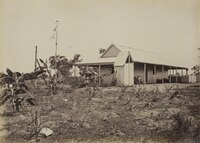 Telegraph Station, Pine Creek in 1879
 -
 Pine Creek School, 1912
 -
 Pine Creek Police Station in the 1920s
 -
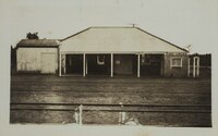 Pine Creek Railway Station, 1930
 -
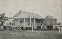
 Pine Creek Hotel, c. 1930
 -
 Tourist map of Pine Creek, 1992


Climate
| Climate data for Pine Creek Council, elevation 206 m (676 ft), (2000–2011 normals) | |||||||||||||
|---|---|---|---|---|---|---|---|---|---|---|---|---|---|
| Month | Jan | Feb | Mar | Apr | May | Jun | Jul | Aug | Sep | Oct | Nov | Dec | Year |
| Record high °C (°F) | 37.4 (99.3) |
37.1 (98.8) |
37.2 (99.0) |
37.3 (99.1) |
36.1 (97.0) |
35.2 (95.4) |
35.1 (95.2) |
37.0 (98.6) |
39.9 (103.8) |
41.2 (106.2) |
40.4 (104.7) |
39.9 (103.8) |
41.2 (106.2) |
| Mean daily maximum °C (°F) | 32.9 (91.2) |
32.6 (90.7) |
33.2 (91.8) |
33.7 (92.7) |
31.9 (89.4) |
29.8 (85.6) |
30.6 (87.1) |
32.3 (90.1) |
35.5 (95.9) |
37.0 (98.6) |
36.5 (97.7) |
34.6 (94.3) |
33.4 (92.1) |
| Mean daily minimum °C (°F) | 23.9 (75.0) |
23.8 (74.8) |
23.4 (74.1) |
22.1 (71.8) |
19.5 (67.1) |
16.7 (62.1) |
16.5 (61.7) |
17.7 (63.9) |
21.6 (70.9) |
23.8 (74.8) |
24.3 (75.7) |
24.2 (75.6) |
21.5 (70.6) |
| Record low °C (°F) | 20.4 (68.7) |
20.7 (69.3) |
16.0 (60.8) |
15.4 (59.7) |
11.1 (52.0) |
9.8 (49.6) |
9.8 (49.6) |
11.7 (53.1) |
13.5 (56.3) |
16.7 (62.1) |
19.7 (67.5) |
20.2 (68.4) |
9.8 (49.6) |
| Average rainfall mm (inches) | 333.7 (13.14) |
343.4 (13.52) |
254.6 (10.02) |
85.6 (3.37) |
9.7 (0.38) |
0.4 (0.02) |
0.1 (0.00) |
2.6 (0.10) |
8.5 (0.33) |
36.5 (1.44) |
103.1 (4.06) |
303.4 (11.94) |
1,481.6 (58.32) |
| Average rainy days (≥ 1.0 mm) | 19.2 | 16.9 | 14.1 | 4.2 | 0.5 | 0.2 | 0.0 | 0.3 | 1.1 | 2.9 | 8.4 | 16.3 | 84.1 |
| Source: Australian Bureau of Meteorology | |||||||||||||
Notes
- ^ In 1872 a newspaper reported that "A great many statements have been made about gold being found in holes of the telegraph post, and other unimaginable places. Such statements are incorrect, and given out by interested parties." The story of the pole holes as the source of the find perpetuates, although no first-hand accounts have been uncovered to authenticate it.
References
- ^ "Place Names Register Extract re "Pine Creek"". NT Place Names Register. Northern Territory Government. Retrieved 24 March 2019.
- ^ Australian Bureau of Statistics (28 June 2022). "Pine Creek". 2021 Census QuickStats. Retrieved 4 March 2021.
- ^ "Untitled proclamation re the "Town of Playford"" (PDF). The South Australian Government Gazette. Government of South Australia. 24 January 1889. p. 164. Retrieved 24 March 2019.
- ^ "Pine Creek". northernterritory.com. Retrieved 30 May 2024.
- ^ "BushTel – Remote Communities of the NT". bushtel.nt.gov.au. Retrieved 30 May 2024.
- ^ "2021 Pine Creek (NT), Census All persons QuickStats | Australian Bureau of Statistics". www.abs.gov.au. Retrieved 30 May 2024.
- ^ "Native Title over Pine Creek finally recognised". www.nlc.org.au. 9 April 2019. Retrieved 30 May 2024.
- ^ ""It took us 20 years, but we finally got it!" Native Title finally recognised in Pine Creek". www.nlc.org.au. 17 April 2019. Retrieved 30 May 2024.
- ^ "Debates Day 3 - Thursday 7 July 2005". Territory Stories. Darwin: Legislative Assembly of the Northern Territory. 7 July 2005. hdl:10070/423069. Retrieved 30 May 2024.
- ^ Woods, David (10 July 2014). "Pine Creek residents devastated at news Frances Creek iron ore mine will close". Northern Territory News. Retrieved 30 May 2024.
- ^ "Pine Creek (village)". NT Place Names Register. Retrieved 30 May 2024.
- ^ "Reminiscences of S.W. Herbert • Mixed material • State Library of South Australia". collections.slsa.sa.gov.au. Retrieved 30 May 2024.
- ^ Pine Creek, Sydney Morning Herald, (8 February 2004)
- ^ "Public School, Pine Creek". Northern Territory Times and Gazette. Vol. XXII, no. 1314. Northern Territory, Australia. 3 February 1899. p. 4. Retrieved 30 May 2024 – via National Library of Australia.
- ^ NRETAS Frances Creek, Ochre Hill (MLA24727) and Millers deposit proposed Iron Mine Cultural Heritage Study Archived 29 March 2012 at the Wayback Machine
- ^ Donovan, P. F. (Peter Francis) (1979), Pine Creek and district : a history, [self published], retrieved 31 May 2024
- ^ "Pine Creek Home (1931 - 1933)". Find & Connect. Retrieved 31 May 2024.
- ^ "Pine Creek Home (1940 - 1941)". Find & Connect. Retrieved 31 May 2024.
- ^ "Pine Creek Gold Rush | Monument Australia". monumentaustralia.org.au. Retrieved 30 May 2024.
- ^ Bauer, FH. "Wentworth D'Arcy Uhr (1845–1907)". Australian Dictionary of Biography. Retrieved 30 May 2024.
- ^ "Gold at Port Darwin". The Queenslander. Vol. VII, no. 358. Queensland, Australia. 14 December 1872. p. 6. Retrieved 30 May 2024 – via National Library of Australia.
- ^ "Gold at Port Darwin". The Queenslander. Vol. VII, no. 358. Queensland, Australia. 14 December 1872. p. 6. Retrieved 23 June 2016 – via National Library of Australia.
- ^ Mitchell, Scott; Mitchell, Scott; Heritage Surveys, March 1996 (1996), Pine Creek Goldfields and the industrial heritage of Gold Mining at Pine Creek, Northern Territory : A study conducted on behalf of the National Trust of Australia (Northern Territory Branch), National Trust of Australia (NT Branch), retrieved 30 May 2024
{{citation}}: CS1 maint: numeric names: authors list (link) - ^ McCarthy, Justin; Kostoglou, Parry; National Trust of Australia (Northern Territory); J. McCarthy & Associates (1986), Pine Creek heritage zone archaeological survey, J. McCarthy & Associates, retrieved 30 May 2024
- ^ "Ah Hong Passes On". Centralian Advocate. Vol. VI, no. 261. Northern Territory, Australia. 6 June 1952. p. 1. Retrieved 30 May 2024 – via National Library of Australia.
- ^ Petrick, Jose; Petrick, Jose. Street names tell history of Alice Springs (1996), The history of Alice Springs through landmarks and street names (3rd ed.), J. Petrick, ISBN 978-0-646-30256-0
- ^ Bathgate, Jane (1 January 2004). "Replenished: sources of meaning, sources of history in the Pine Creek area, Northern Territory, Australia". Charles Darwin University. doi:10.25913/5ea25faf5d003. Retrieved 30 May 2024.
- ^ "Frances Creek Project". Territory Resources Limited. Archived from the original on 30 September 2007. Retrieved 12 July 2007.
- ^ "Territory Resources commences production of iron ore" (Press release). Territory Resources Limited. 19 June 2007. Archived from the original (pdf) on 29 September 2007. Retrieved 12 July 2007.
- ^ Palin, Megan; McCue, Fred (23 October 2010). "Oprah Winfrey, Barack Obama and the royal couple Kate and Will were easier to access than Top Gear stars on their Northern Territory visits". NT News. Retrieved 11 April 2020.
- ^ Brown, Carmen; Brann, Matt (8 April 2020). "Iron ore exports set to resume from Northern Territory after five-year hiatus". ABC News. Australian Broadcasting Corporation. Retrieved 9 April 2020.
- ^ Prestipino, David (10 March 2024). "Pine Creek revival on cards as NT discovers two critical minerals". National Indigenous Times. Retrieved 30 May 2024.
- ^ "Pine Creek, NT". Aussie Towns. Retrieved 11 April 2020.
- ^ Drymalik, C. Commonwealth, Australian National and South Australian Railways Rollingstock, Version 6 2012, pg 59-64
- ^ Litchfield Council Stuart Highway Archived 1 October 2010 at the Wayback Machine
- ^ Australian Steam website Commonwealth Railways - North Australia Railway
- ^ "Pine Creek Airfield, NT during WW2". www.ozatwar.com. Retrieved 26 October 2023.
- ^ "McDonald Airfield, Northern Territory - also known as Burkholder Field, during WW2". www.ozatwar.com. Retrieved 26 October 2023.
- ^ Dunn, P Pine Creek Airfield Australia at War website
- ^ "Pine Creek Bakery". Heritage Register. Northern Territory Government. Retrieved 24 March 2019.
- ^ "Pine Creek Post Office and Repeater Station". Heritage Register. Northern Territory Government. Retrieved 24 March 2019.
- ^ "North Australia Railway (NAR) remnants at Pine Creek". Heritage Register. Northern Territory Government. Retrieved 24 March 2019.
- ^ "Old Pine Creek Butchery". Heritage Register. Northern Territory Government. Retrieved 24 March 2019.
- ^ "Old Playford Club Hotel". Heritage Register. Northern Territory Government. Retrieved 24 March 2019.
- ^ "Old Bonrook Station Homestead". Heritage Register. Northern Territory Government. Retrieved 24 March 2019.
- ^ "Pine Creek Railway Precinct". Heritage Register. Northern Territory Government. Retrieved 24 March 2019.
- ^ "Climate statistics for Australian locations: PINE CREEK COUNCIL". 8 April 2024.
External links
| International | |
|---|---|
| National | |