Ponderosa Park, Colorado
Geography
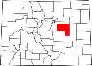
Ponderosa Park is located on the western border of Elbert County. It is bordered to the southeast by the town of Elizabeth. Colorado State Highway 86 forms the southern edge of the CDP, leading east 9 miles (14 km) to Kiowa, the county seat, and west 7 miles (11 km) to Franktown. Castle Rock is 13 miles (21 km) to the west, and Denver is 37 miles (60 km) to the northwest.
The Ponderosa Park CDP has an area of 9,333 acres (37.770 km), all land.
Climate
This climate type is usually found in the outskirts of true deserts in low-latitude, semiarid regions. It has a cooler, wetter winter resulting from the higher latitude and mid-latitude frontal cyclone activity. Annual precipitation totals are greater than in tropical and subtropical desert climates. Yearly variations in amount are not as extreme as in the true deserts but are nevertheless large. The Köppen Climate Classification subtype for this climate is "BSk". (Tropical and Subtropical Steppe Climate).
| Climate data for Ponderosa Park, Colorado | |||||||||||||
|---|---|---|---|---|---|---|---|---|---|---|---|---|---|
| Month | Jan | Feb | Mar | Apr | May | Jun | Jul | Aug | Sep | Oct | Nov | Dec | Year |
| Mean daily maximum °C (°F) | 6 (43) |
8 (46) |
11 (51) |
16 (60) |
21 (69) |
27 (80) |
30 (86) |
29 (84) |
25 (77) |
19 (66) |
11 (52) |
7 (45) |
17 (63) |
| Mean daily minimum °C (°F) | −9 (15) |
−8 (18) |
−5 (23) |
−1 (31) |
4 (40) |
9 (49) |
13 (55) |
12 (54) |
8 (46) |
2 (35) |
−5 (23) |
−8 (17) |
1 (34) |
| Average precipitation mm (inches) | 7.6 (0.3) |
7.6 (0.3) |
23 (0.9) |
33 (1.3) |
64 (2.5) |
48 (1.9) |
56 (2.2) |
48 (1.9) |
28 (1.1) |
20 (0.8) |
18 (0.7) |
7.6 (0.3) |
360 (14.1) |
| Source: Weatherbase | |||||||||||||
Demographics
The United States Census Bureau initially defined the Ponderosa Park CDP for the 1980 United States Census.
| Year | Pop. | ±% |
|---|---|---|
| 1990 | 1,640 | — |
| 2000 | 3,112 | +89.8% |
| 2010 | 3,232 | +3.9% |
| 2020 | 3,334 | +3.2% |
| Source: United States Census Bureau | ||
See also
- Outline of Colorado
- State of Colorado
References
- ^ "State of Colorado Census Designated Places - BAS20 - Data as of January 1, 2020". United States Census Bureau. Retrieved December 22, 2020.
- ^ "U.S. Board on Geographic Names: Domestic Names". United States Geological Survey. Retrieved December 22, 2020.
- ^ United States Census Bureau. "Ponderosa Park CDP, Colorado". Retrieved April 16, 2023.
- ^ "Zip Code 80107 Map and Profile". zipdatamaps.com. 2020. Retrieved December 22, 2020.
- ^ "US Gazetteer files: 2010, 2000, and 1990". United States Census Bureau. February 12, 2011. Retrieved April 23, 2011.
- ^ "Weatherbase.com". Weatherbase. 2013. Retrieved on May 5, 2013.
