Pozlovice
Geography
Pozlovice is located about 13 kilometres (8 mi) southeast of Zlín. It lies in the Vizovice Highlands. The highest point is the hill Obětová at 511 m (1,677 ft). The streams Luhačovický potok and Pozlovický potok flow through the market town. The eastern part of the municipal territory lies within the White Carpathians Protected Landscape Area.
The Luhačovice Reservoir is built on the Luhačovický potok. It was built in 1912–1930. Its primary task was flood protection, but today it is mainly used for sports and recreational purposes.
History
The first written mention of Pozlovice is from 1287. Until the first half of the 17th century, the village was part of the Starý Světlov estate. From the first half of the 17th century until 1945, it was part of the Luhačovice estate, owned by the Serényi family. In 1758, Pozlovice was promoted to a market town by Empress Maria Theresa.
Demographics
|
|
| ||||||||||||||||||||||||||||||||||||||||||||||||||||||
| Source: Censuses | ||||||||||||||||||||||||||||||||||||||||||||||||||||||||
Transport
There are no railways or major roads passing through the municipality.
Sights

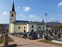
The main cultural landmark of Pozlovice is the Church of Saint Martin. It was built in the 17th century on the site of an older medieval church.
Twin towns – sister cities
Pozlovice is twinned with:
 Rajecké Teplice, Slovakia
References
- ^ "Population of Municipalities – 1 January 2024". Czech Statistical Office. 2024-05-17.
- ^ "Luhačovická přehrada" (in Czech). Městys Pozlovice. Retrieved 2024-03-01.
- ^ "Městys Pozlovice" (PDF) (in Czech). Městys Pozlovice. Retrieved 2024-03-01.
- ^ "Historický lexikon obcí České republiky 1869–2011" (in Czech). Czech Statistical Office. 2015-12-21.
- ^ "Population Census 2021: Population by sex". Public Database. Czech Statistical Office. 2021-03-27.
- ^ "Kostel sv. Martina" (in Czech). National Heritage Institute. Retrieved 2024-03-01.
- ^ "Turistika" (in Czech). Městys Pozlovice. Retrieved 2023-08-06.