Provincia Di Brescia
| Year | Pop. | ±% |
|---|---|---|
| 1951 | 858,243 | — |
| 1961 | 882,949 | +2.9% |
| 1971 | 957,686 | +8.5% |
| 1981 | 1,017,093 | +6.2% |
| 1991 | 1,044,544 | +2.7% |
| 2001 | 1,108,776 | +6.1% |
| 2011 | 1,238,044 | +11.7% |
| 2021 | 1,253,157 | +1.2% |
| Source: ISTAT | ||
With an area of 4,785 km, it is the biggest province of Lombardy. It is also the second province of the region for the number of inhabitants and fifth in Italy (first, excluding metropolitan cities).
It borders the province of Sondrio to the north and north west, the province of Bergamo to the west, the province of Cremona to the south west and south, the province of Mantua to the south. On its northeastern border, Lake Garda – Italy's largest – is divided between Brescia and the neighboring provinces of Verona (Veneto region) and Trentino (Trentino-Alto Adige/Südtirol region).
The province stretches between Lake Iseo in the west, Lake Garda in the east, the Southern Rhaetian Alps in the north and the Lombardian plains in the south. The main rivers of the province are the Oglio, the Mella and the Chiese.
Besides Brescia, other important towns in the province are Travagliato, Darfo Boario Terme, Desenzano del Garda, Palazzolo sull'Oglio, Montichiari, Ghedi, Chiari, Rovato, Gussago, Rezzato, Concesio, Orzinuovi, Salò, Gardone Val Trompia and Lumezzane.
Geography
The province of Brescia is the largest in the region, boasts three main lakes, Lake Garda, Lake Iseo and Lake Idro, plus several other smaller lakes, three valleys, Val Camonica, Val Trompia and Valle Sabbia, as well as a wide flat area south of the city, known as the Bassa Bresciana, and several hilly areas surrounding the city landscape and extending eastwards towards Veneto and west to Franciacorta.
Due to the altitude and morphological variety and the presence of large lakes, the province includes all kinds of biomes in Europe: from something similar to the maquis shrubland up to the perennial snow of Adamello (with the largest glacier in the Italian Alps).
Valleys
The three main valleys on the territory of Brescia are the Val Camonica, crossed by the river Oglio and inserted in the northwestern part of the province from Adamello to Lake Iseo; Val Trompia, the river Mella basin, between the municipalities of Concesio and Collio; and the Valle Sabbia which includes the municipalities from Serle to Bagolino along the course of the river Chiese.
All the three valleys have the point of union the Croce Domini Pass, which takes the name from the "cross" formed by the union of the three basins.
Lakes
Within the province there are eight lakes. The main lake basin, in both dimensional, climatic and cultural terms, is Lake Garda, shared with the Veneto and Trentino regions, which with its 370 km of surface is the biggest lake in Italy. Because of its size, the lake has a considerable influence on the climate and the surrounding environment, generating a micro-geographic area in a more mitigated climate both in summer and winter.
Lake Iseo is the second lake of the area, and is situated at about 180 m above sea level, in an area called Sebino, between Val Camonica (north) and Franciacorta (south), which divides the provinces of Bergamo and Brescia.
Lake Idro, the third lake within the provincial territory, is located in Valle Sabbia, on the border between Brescia and the province of Trento, and differs from the other two main lakes for its modest size. The waters of the lake are mainly exploited for the irrigation of crops in contiguous territories, as well as for the production of energy through a small power plant located in the municipality of Vobarno.
Other small lakes in the province are: Lago della Vacca (at an elevation of 2,358 m, in one of the coldest points of the province), Lago d'Arno, Lago Aviolo, Lago Baitone, Lago Moro and Lago di Valvestino.
-
Lake Valvestino
-
Lake Moro and Darfo Boario Terme
Rivers
There are about 45 watercourses crossing the territory of the province, but almost all of them are torrents. The only watercourses that can be defined as real rivers are just three: Oglio, Chiese and Mella; divided between the three main valleys.
-
Chiese crosses Valle Sabbia
-
Mella crosses Val Trompia then part of the southern countryside
-
Source of the river Oglio in the upper Valle Camonica
-
Typical ditch in Bassa Bresciana
Extreme points
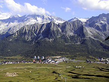
- Highest point: Mount Adamello, Saviore dell'Adamello (3,539 m)
- Highest settlement: Tonale Pass, Ponte di Legno (1,883 m)
- Northernmost municipality: Ponte di Legno
- Southernmost municipality: Fiesse
- Easternmost municipality: Limone sul Garda
- Westernmost municipality: Pontoglio


