Punta Santiago, Puerto Rico
History

The fishing village of Punta Santiago was originally called Playa de Humacao as it was the closest beach to Humacao Pueblo, the historic and administrative downtown area of Humacao. The community of Punta Santiago used to be part of two former barrios of Humacao, one called Humacao Playa and the other called Mabú. By the end of the 19th century barrio Mabú had been eliminated and incorporated into barrio Playa, now renamed Punta Santiago after the geographical headland or point (punta) where the fishing village is located.
Since December 1938, Cayo Santiago, located immediately off Punta Santiago, has been the home to a population of free roaming Rhesus macaques imported from India by the School of Tropical Medicine in San Juan, the Columbia University College of Physicians and Surgeons and the University of Puerto Rico.
The area where the Humacao nature reserve is located today saw a number of bunkers and defensive infrastructure built during the Second World War, including a lookout post at the top of El Morrillo hill. This area which contains a number of mangrove and Pterocarpus forests was later proclaimed a wildlife refuge in 1986.
Hurricane Maria
Hurricane Maria hit Puerto Rico on September 20, 2017. The hurricane eye entered the island close to Punta Yeguas in Yabucoa, not far from Punta Santiago. The barrio was particularly vulnerable to the associated storm surges. According to Father José Colón, the local Catholic priest, the hurricane caused the total flooding of Punta Santiago.
"The town was flooded from all directions, from the ocean, rain and nearby rivers..."
Punta Santiago was one of the most impacted communities in the aftermath of the hurricane. It was the location of the viral image of an SOS message written on one of the roads of the community. The Punta Santiago Vacation Center was greatly affected by the hurricane, and it remained abandoned by 2023.
- Effects of Hurricane Maria
-
 PR National Guard clearing debris at Punta Santiago after Hurricane Maria in 2017
 -
 PR National Guard clearing debris at Punta Santiago after Hurricane Maria in 2017
.jpg)
.jpg)
Flood zone
In 2019, updated flood zone maps show that because of its location- where most cyclones enter the island, Humacao is one of the most vulnerable areas of Puerto Rico. Humacao was working on flood mitigation plans and shared that its barrios located on the coast; Antón Ruíz, Punta Santiago, Río Abajo, Buena Vista and Candelero Abajo barrios, are prone to flooding and in danger of being completed destroyed by a hurricane.
Demographics
Punta Santiago was in Spain's gazetteers until Puerto Rico was ceded by Spain in the aftermath of the Spanish–American War under the terms of the Treaty of Paris of 1898 and became an unincorporated territory of the United States. In 1899, the United States Department of War conducted a census of Puerto Rico finding that the combined population of Punta Santiago and San Francisco barrios was 1,754.
| Census | Pop. | Note | %± |
|---|---|---|---|
| 1910 | 988 | — | |
| 1920 | 1,201 | 21.6% | |
| 1930 | 1,847 | 53.8% | |
| 1940 | 2,185 | 18.3% | |
| 1950 | 2,498 | 14.3% | |
| 1960 | 2,433 | −2.6% | |
| 1970 | 2,351 | −3.4% | |
| 1980 | 5,750 | 144.6% | |
| 1990 | 5,900 | 2.6% | |
| 2000 | 5,524 | −6.4% | |
| 2010 | 4,723 | −14.5% | |
| 2020 | 3,716 | −21.3% | |
| U.S. Decennial Census 1899 (shown as 1900) 1910-1930 1930-1950 1980-2000 2010 2020 | |||
The population of Punta Santiago in 2020 was 3,716, a 21.3% decrease from 4,723 in 2010.
Landmarks and places of interest
- Cayo Batata and Cayo Santiago (Monkey Island), location of Caribbean Primate Research Center UPR-MSC
- Humacao Nature Reserve
- Pterocarpus Forest of Humacao
- Punta Santiago Beach and Vacation Center
- Punta Santiago fishing village and pier
Gallery
-
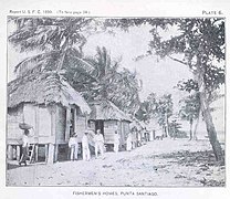 Fishermen houses (1899)
 -

-
 Rhesus macaque (Macaca mulatta) in Cayo Santiago
 -
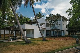 Punta Santiago Vacation Center (2021)
 -
 Old Customs House of Humacao (2023)


See also
References
- ^ "US Gazetteer 2019". US Census. US Government.
- ^ U.S. Geological Survey Geographic Names Information System: Punta Santiago barrio
- ^ Picó, Rafael; Buitrago de Santiago, Zayda; Berrios, Hector H. Nueva geografía de Puerto Rico: física, económica, y social, por Rafael Picó. Con la colaboración de Zayda Buitrago de Santiago y Héctor H. Berrios. San Juan Editorial Universitaria, Universidad de Puerto Rico,1969.
- ^ "Census profile: Punta Santiago barrio, Humacao Municipio, PR". Census Reporter. Retrieved 2023-08-13.
- ^ "Punta Santiago Reserva Natural de Humacao". Discover Puerto Rico (in Spanish). Retrieved 2023-08-13.
- ^ Estado Libre Asociado de Puerto Rico, Junta de Planificación (1955). Municipio de Humacao Memoria Suplementaria al Mapa de Límites del Municipio y sus Barrios (in Spanish) (52 ed.). San Juan, Puerto Rico: Oficina del Gobernador. pp. 40–41.
- ^ "Municipio de Humacao - EnciclopediaPR". 2010-09-07. Retrieved 2023-08-13.
- ^ Geocaching. "Geocaching - The Official Global GPS Cache Hunt Site". www.geocaching.com. Retrieved 2021-12-15.
- ^ "Reserva Natural Reserva Natural de Humacao — Puerto DRNA "Navega por el ambiente"". www.drna.pr.gov. Retrieved 2021-12-15.
- ^ "What the hurricanes revealed about Puerto Rico". America Magazine. December 27, 2017.
- ^ "Quedó nuevo Punta Santiago en Humacao". Primera Hora (in Spanish). 2018-07-05. Retrieved 2023-08-13.
- ^ "Centro vacacional de Punta Santiago: paraíso perdido y en el limbo". Primera Hora (in Spanish). 2023-04-03. Retrieved 2023-08-13.
- ^ Alvarado León, Gerardo E. "Sobre 250,000 estructuras están en zonas inundables [More than 250,000 structures in flood zones]" (PDF). Junta de Planificación - Gobierno de Puerto Rico (in Spanish). El Nuevo Día. Retrieved 3 July 2019.
- ^ Solano Quintana, Bárbara. "Piden participación ciudadana para revisión del plan de mitigación de Humacao" (PDF). El Nuevo Día (in Spanish). Retrieved 3 July 2019 – via Junta de Planificación Gobierno de Puerto Rico.
- ^ "Anuario del comercio, de la industria, de la magistratura y de la administración. 1881". Biblioteca Nacional de España (in Spanish). p. 1614. Retrieved 4 April 2023.
- ^ Joseph Prentiss Sanger; Henry Gannett; Walter Francis Willcox (1900). Informe sobre el censo de Puerto Rico, 1899, United States. War Dept. Porto Rico Census Office (in Spanish). Imprenta del gobierno. p. 163.
- ^ "Report of the Census of Porto Rico 1899". War Department Office Director Census of Porto Rico. Archived from the original on July 16, 2017. Retrieved September 21, 2017.
- ^ "Table 3-Population of Municipalities: 1930 1920 and 1910" (PDF). United States Census Bureau. Archived (PDF) from the original on August 17, 2017. Retrieved September 21, 2017.
- ^ "Table 4-Area and Population of Municipalities Urban and Rural: 1930 to 1950" (PDF). United States Census Bureau. Archived (PDF) from the original on August 30, 2015. Retrieved September 21, 2014.
- ^ "Table 2 Population and Housing Units: 1960 to 2000" (PDF). United States Census Bureau. Archived (PDF) from the original on July 24, 2017. Retrieved September 21, 2017.
- ^ Puerto Rico: 2010 Population and Housing Unit Counts.pdf (PDF). U.S. Dept. of Commerce Economics and Statistics Administration U.S. Census Bureau. 2010. Archived (PDF) from the original on 2017-02-20. Retrieved 2019-08-02.
- ^ https://censo.estadisticas.pr/node/499=live