Queen Victoria Rock
Description
Queen Victoria Rock is located within Arches National Park and like many of the rock formations in the park, it is composed of Entrada Sandstone, specifically the Slick Rock Member overlaying the Dewey Bridge Member. Topographic relief is significant as the summit rises 400 feet (122 meters) above the Park Avenue Trail in 250 feet (76 meters) laterally. Precipitation runoff from Queen Victoria Rock drains to the nearby Colorado River via Courthouse Wash. This landform's descriptive toponym has been officially adopted by the United States Board on Geographic Names, and is so named because the feature resembles the profile of Queen Victoria sitting on a chair, although it may look more like Whistler's Mother. The first ascent of the summit was made in November 1986 by Charlie Fowler and Dan Grandusky via Dusty Shadows rock-climbing route (III, A-2+). Charlie Fowler and Alison Sheets also climbed the route, Queen For A Day, rated (I, A-2).
Climate
According to the Köppen climate classification system, Queen Victoria Rock is located in a cold semi-arid climate zone with cold winters and hot summers. Spring and fall are the most favorable seasons to experience Arches National Park, when highs average 60 to 80 °F (15 to 25 °C) and lows average 30 to 50 °F (0 to 10 °C). Summer temperatures often exceed 100 °F (40 °C). Winters are cold, with highs averaging 30 to 50 °F (0 to 10 °C), and lows averaging 0 to 20 °F (−20 to −5 °C). As part of a high desert region, it can experience wide daily temperature fluctuations. The park receives an average of less than 10 inches (25 cm) of rain annually.
Gallery
-
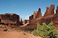
 Park Avenue with Queen Victoria Rock in upper right corner
 -
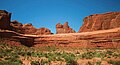
 Park Avenue with Queen Victoria Rock in upper right corner
 -
 Queen Victoria Rock in upper left corner
 -
 Queen Victoria Rock to right. The Candelabrum furthest to left.
 -
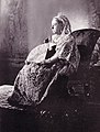 Queen Victoria for comparison to rock
 -
 Queen Victoria for comparison to rock
 -
 Whistler's Mother for comparison to rock
 -
 East aspect
 -
 Interpretive sign showing sandstone strata on Queen Victoria Rock
 -
 Queen Victoria Rock centered in the distance
 -
 East aspect centered
 -


.jpg)


.jpg)

_2.jpg)
See also
References
- ^ "Queen Victoria Rock". Geographic Names Information System. United States Geological Survey, United States Department of the Interior. Retrieved 2024-10-08.
- ^ "Queen Victoria Rock - 4,820' UT". listsofjohn.com. Retrieved 2024-09-14.
- ^ Stanley William Lohman, The Geologic Story of Arches National Park, U.S. Government Printing Office, 1975, p. 63.
- ^ Secrets of the National Parks: The Experts' Guide to the Best Experiences Beyond the Tourist Trail, Mel White, National Geographic Society (U. S.), National Geographic Books, 2013, ISBN 9781426210150, p. 113.
- ^ First Ascent Timeline, deserttowersbook.com, Retrieved 2024-09-14.
- ^ Desert Climbing, Eric Bjørnstad, American Alpine Journal, 1987, americanalpineclub.org
- ^ Peel, M. C.; Finlayson, B. L. & McMahon, T. A. (2007). "Updated world map of the Köppen−Geiger climate classification". Hydrol. Earth Syst. Sci. 11 (5): 1633–1644. Bibcode:2007HESS...11.1633P. doi:10.5194/hess-11-1633-2007. ISSN 1027-5606. S2CID 9654551.
External links
- Queen Victoria Rock Climbing: Mountainproject.com
- Arches National Park: National Park Service
Places adjacent to Queen Victoria Rock | ||||||||||||||||
|---|---|---|---|---|---|---|---|---|---|---|---|---|---|---|---|---|
| ||||||||||||||||