Rural Municipality Of Fillmore No. 96
History
The RM of Fillmore No. 96 incorporated as a rural municipality on December 13, 1909. It was previously Local Improvement District No. 6–E–2.
Geography
Communities and localities
The following urban municipalities are surrounded by the RM.
The following unincorporated communities are within the RM.
- Localities
- Huronville
Osage Wildlife Refuge
Osage Wildlife Refuge (49°56′00″N 103°33′02″W / 49.9334°N 103.5505°W) is a wildlife conservation area in the RM of Fillmore, about 4.8 kilometres (3.0 mi) south-east of Osage along Highway 33.
Demographics
In the 2021 Census of Population conducted by Statistics Canada, the RM of Fillmore No. 96 had a population of 224 living in 105 of its 124 total private dwellings, a change of 0.4% from its 2016 population of 223. With a land area of 815.57 km (314.89 sq mi), it had a population density of 0.3/km (0.7/sq mi) in 2021.
In the 2016 Census of Population, the RM of Fillmore No. 96 recorded a population of 223 living in 98 of its 119 total private dwellings, a -12.5% change from its 2011 population of 255. With a land area of 828.33 km (319.82 sq mi), it had a population density of 0.3/km (0.7/sq mi) in 2016.
Government
The RM of Fillmore No. 96 is governed by an elected municipal council and an appointed administrator that meets on the second Wednesday of every month. The reeve of the RM is Russell Leguee while its administrator is Vernna Wiggins. The RM's office is located in Fillmore.
Transportation
- Rail
- Souris-Arcola-Regina Section Canadian Pacific Railway (CPR) —serves Stoughton, Heward, Creelman, Fillmore, Osage, Tyvan, Francis, and Sedley
- Roads
- Highway 33—serves Fillmore and Village of Osage
- Highway 606—serves Fillmore
- Highway 711—serves the Village of Osage
- Highway 619—serves the Village of Osage
Gallery
-
 Cemetery in Huronville
 -
 Plaque in Huronville
 -
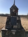 Cairn in Huronville


