Saint-Léger-du-Bourg-Denis
Geography
Saint-Léger-du-Bourg-Denis is a light industrial suburban town surrounded by woodland and situated in the Roumois, just 3 miles (4.8 km) east of the centre of Rouen at the junction of the D42 and the D138 roads.
History
Etymology
The current official name of the town derives from a mistaken etymology dating back to French Revolution. Political authorities have retained and not reformed this quaint error to the present day. A more rational name would be "Saint-Léger-Bourdeny", after its ancient name "Bourdeny", a Gallo-Roman toponym in -acum, formed with the Germanic personal name Burdinus, thus Burdiniacum > Bourdeny. Burdinus, a given name, gave rise to the patronymic surnames Bourdain and Bourdin, common in west central France.
A similar name can be found in the Merovingian toponym Bourdainville.
Heraldry
 |
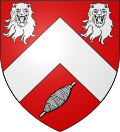
The arms of Saint-Léger-du-Bourg-Denis are blazoned : Gules, a chevron between 2 leopards heads and a spindle bendwise sinister argent.
|
Population
| Year | Pop. | ±% p.a. |
|---|---|---|
| 1968 | 2,144 | — |
| 1975 | 2,381 | +1.51% |
| 1982 | 2,953 | +3.12% |
| 1990 | 2,772 | −0.79% |
| 1999 | 3,124 | +1.34% |
| 2007 | 3,263 | +0.55% |
| 2012 | 3,449 | +1.11% |
| 2017 | 3,450 | +0.01% |
| Source: INSEE | ||
Places of interest
- The church of St.Léger, dating from the sixteenth century.
- The debris of a tenth-century castle.
See also
References
- ^ "Répertoire national des élus: les maires" (in French). data.gouv.fr, Plateforme ouverte des données publiques françaises. 4 May 2022.
- ^ (in French). The National Institute of Statistics and Economic Studies. 19 December 2024 https://www.insee.fr/fr/statistiques/8288323?geo=COM-76599.
{{cite web}}: Missing or empty|title=(help) - ^ Population en historique depuis 1968, INSEE
External links
- Official website of Saint-Léger-du-Bourg-Denis (in French)