Selenite Peak
Description
Selenite Peak is the fifth-highest peak of the Selenite Range which is a subset of the Great Basin Ranges. This peak is set on land managed by the Bureau of Land Management, and is the highest point of the BLM's Selenite Mountains Wilderness Study Area. It is situated six miles (9.7 km) southeast of the town of Gerlach, and five miles (8.0 km) northeast of Empire. Topographic relief is significant as the summit rises 3,100 feet (940 meters) above the valley floor in three miles. This landform's toponym has been officially adopted by the U.S. Board on Geographic Names.
Climate
Selenite Peak is set in the Black Rock Desert which has hot summers and cold winters. The desert is an example of a cold desert climate as the desert's elevation makes temperatures cooler than lower elevation deserts. Due to the high elevation and aridity, temperatures drop sharply after sunset. Summer nights are comfortably cool. Winter highs are generally above freezing, and winter nights are bitterly cold, with temperatures often dropping well below freezing.
Gallery
-
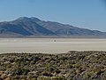
 North aspect
 -
 Selenite Peak and Gerlach at sunset
 -
 North aspect

.jpg)
See also
References
- ^ United States Geological Survey topographical map - Empire
- ^ "Selenite Peak, Nevada". Peakbagger.com. Retrieved August 27, 2022.
- ^ "Selenite Peak - 7,115' NV". listsofjohn.com. Retrieved August 27, 2022.
- ^ "Selenite Peak". Geographic Names Information System. United States Geological Survey, United States Department of the Interior. Retrieved August 27, 2022.
- ^ Peel, M. C.; Finlayson, B. L.; McMahon, T. A. (2007). "Updated world map of the Köppen−Geiger climate classification". Hydrol. Earth Syst. Sci. 11. ISSN 1027-5606.
External links
- Weather forecast: Selenite Peak
- National Geodetic Survey Data Sheet