Sierra De Guadalupe, Mexico
History

There is evidence that the Aztecs worshipped Tonantzin (Goddess of Sustenance) at Tepeyac hill. The sierra is named after Our Lady of Guadalupe, a Marian apparition that, according to oral and written colonial sources such as the Huei tlamahuiçoltica, Juan Diego saw at the Tepeyac hill.
In 1937, the El Tepeyac National Park was created in the Tepeyac hill, in the eastern portion of the sierra, by decree of the president Lázaro Cárdenas.
Geology
The sierra is a dormant volcano that is part of the Trans-Mexican Volcanic Belt. The basement is made of andesitic and dacitic soil. The last volcanic activity in the area occurred 14 to 15 million years ago.
Ecology

Climate
The sierra has a humid subtropical climate. It rains mostly during summers with rainfall of between 700 and 800 mm (2.5 and 3.5 in) per year. The temperature ranges from 12 to 16 °C (53 to 60 °F).
Fauna
Among the species found in the sierra, it is included the Mexican pine snake, the American kestrel, the roadrunner, the opossum, and the bobcat. Introduced species include the white-tailed deer, tapirs and bisons.
Flora
In the area, quercus trees and xerophile plants are abundant.
Preservation
The area has suffered from environmental deterioration due to deforestation. Part of the eastern part of the sierra was reforested with the introduction of eucalyptus, pinus, cedrus and casuarina trees.
Hills
It is composed of the following hills:
- Cerro del Sombrero or Pico Tres Padres
- Cerro de los Gachupines (2,330 m [7,640 ft])
- Cerro del Chiquihuite (2,730 m [8,960 ft])
- Cerro del Picacho Moctezuma (3,055 m [10,023 ft])
- Cerro del Picacho El Fraile (2,902 m [9,521 ft])
- Cerro del Picacho El Jaral
- Cerro del Tenayo
- Cerro Petlecatl
- Cerro de la Calavera
- Cerro Gordo
- Cerro Zacatenco (2,500 m [8,200 ft])
- Cerro del Guerrero (2,440 m [8,010 ft])
- Cerro de Santa Isabel
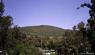
- Cerro del Tepeyac (2,270 m [7,450 ft])
Gallery
-
 Cerro Picacho Moctezuma
 -
 Cerro Zacatenco
 -
 Cerro Los Gachupines
 -
 Cerro del Chiquihuite
 -
 Cerro Gordo
 -
 The Basilica of Our Lady of Guadalupe is located at the Cerro del Tepeyac
 -
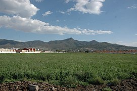 Wider view
 -
 Satellite view


_1.jpg)


.jpg)
References
- ^ "Tonantzin, ¿la diosa azteca que se transformó en la Virgen de Guadalupe?". ADN40. 12 December 2020. Retrieved 14 February 2022.
- ^ Luege Tamargo, José Luis (24 June 2019). "Sierra de Guadalupe". El Universal (in Spanish). Retrieved 14 February 2022.
- ^ "Oklahoma's Blessed Stanley Rother Shrine to be dedicated Nov. 4". KOKI-TV. Oklahoma City. 13 February 2022. Retrieved 14 February 2022.
- ^ Arce, José Luis; Layer, Paul W.; Macías, José Luis; Morales Casique, Eric; García Palomo, Armando; Jiménez Domínguez, Fernando J.; Benowitz, Jeff; Vásquez Serrano, Alberto (2019). "Geology and stratigraphy of the Mexico Basin (Mexico City), central Trans-Mexican Volcanic Belt". Journal of Maps. 15 (2): 320–332. doi:10.1080/17445647.2019.1593251. S2CID 134933346.
- ^ Rivera, Alicia (5 September 2020). "Familias mexiquenses viven sobre depósitos volcánicos". Milenio (in Spanish). Retrieved 14 February 2022.
- ^ Granados Marmolejo, Daniel; Campos Martínez, Juan Carlos (30 May 2005). "De la Sierra de Guadalupe y de cómo rescatar sus tesoros". La Jornada (in Spanish). Retrieved 14 February 2022.
- ^ Flores Vera, Juan Antonio (2007). Estado, metrópoli y políticas sociales (in Spanish). Plaza y Valdés. p. 281. ISBN 9789707226418.
- ^ Cuaderno Estadístico Delegacional, Gustavo A. Madero, Distrito Federal: Edición 1995 (in Spanish). National Institute of Statistics and Geography. 1995. p. 3.
External links
 Media related to Sierra de Guadalupe at Wikimedia Commons