Stevens Peak (California)
Description
This landmark of Hope Valley is set 13 miles (21 km) south of South Lake Tahoe, on land managed by Humboldt–Toiyabe National Forest. Stevens Peak is situated in the Sierra Nevada mountain range, with precipitation runoff from the peak's east slope draining to the West Fork Carson River, whereas the west slope drains into the Upper Truckee River. The summit is situated 1.5 miles (2.4 km) north of line parent Red Lake Peak, and three miles (4.8 km) north of Carson Pass. Topographic relief is significant as the east aspect rises 2,700 feet (820 meters) above California State Route 88 in 1.5 mile.
History
John C. Frémont was the first European-American to see Lake Tahoe, during his second exploratory expedition. He and Charles Preuss saw the lake from the summit of what was likely Stevens Peak (or possibly Red Lake Peak) on February 14, 1844.
This landform's toponym has been officially adopted by the U.S. Board on Geographic Names, and has been in use since at least 1896 when published by the Sierra Club. The name honors Alpine County supervisor J. M. Stevens who operated a stage station in Hope Valley from 1864 through 1866. The USGS surveyed this area in 1889 and labelled the geographic feature on their map.
Climate
According to the Köppen climate classification system, Stevens Peak is located in an alpine climate zone. Most weather fronts originate in the Pacific Ocean and travel east toward the Sierra Nevada mountains. As fronts approach, they are forced upward by the peaks (orographic lift), causing them to drop their moisture in the form of rain or snowfall onto the range.
Gallery
-
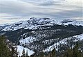 North aspect in winter, from Waterhouse Peak
 -
 Northeast aspect of Stevens Peak from Hope Valley
 -
 Southeast aspect
 -
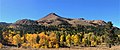 East aspect of Stevens Peak in Hope Valley
 -
 Southeast aspect
 -
 Northeast aspect of Stevens Peak (right of center) from Hope Valley
 -
 Northeast aspect of Stevens Peak (right) from Hope Valley. Red Lake Peak to left.
 -
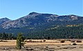 Northeast aspect of Stevens Peak from Hope Valley


See also
Notes
- Lidar measurements show the summit elevation to be 10,051 feet and prominence as 549 feet.
- Stevens Peak blocks some of the view of Lake Tahoe from Red Lake Peak. (Google Earth)
References
- ^ United States Geological Survey topographical map - Carson Pass
- ^ Peter Browning, Place Names of the Sierra Nevada: From Abbot to Zumwalt, 1986, Wilderness Press, ISBN 9780899970479, p. 209.
- ^ "Stevens Peak, California". Peakbagger.com. Retrieved June 29, 2022.
- ^ "Stevens Peak - 10,051' CA". listsofjohn.com. Retrieved June 29, 2022.
- ^ "Stevens Peak". Geographic Names Information System. United States Geological Survey, United States Department of the Interior. Retrieved June 29, 2022.
- ^ "Lake Tahoe Facts and Figures". Tahoe Regional Planning Association. Archived from the original on February 5, 2012. Retrieved October 26, 2008.
- ^ Fred Nathaniel Fletcher (1980), Early Nevada: The Period of Exploration, 1776-1848, University of Nevada Press, ISBN 9780874170610, p. 127
- ^ Douglas E. Kyle, Hero Eugene Rensch, Ethel Grace Rensch, Mildred Brooke Hoover, William Abeloe (2002), Historic Spots in California, Fifth Edition, Stanford University Press, ISBN 9780804778176
- ^ Sierra Club Bulletin, Volume 1, 1896, p. 13
- ^ Erwin Gustav Gudde (1960), California Place Names, University of California Press, p. 321
- ^ "Climate of the Sierra Nevada". Encyclopædia Britannica.
External links
- Weather forecast: Stevens Peak