Strouden Park
Strouden Park or Strouden is an area of Bournemouth, Dorset, England.

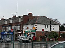
Shops and post office in 2008 
Woodbury Avenue in Strouden Park 
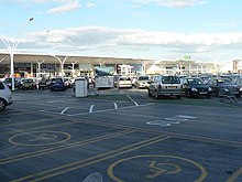
Castlepoint Shopping Centre, Strouden Park
History

On 17 April 2021, the local post office and convenience store was destroyed in a fire.
Geography
Strouden Park is north of Queen's Park, west of Townsend and east of Redhill. Woodbury is an area of Strouden Park. Woodbury Roundabout is a major intersection of the A3060 road.

Facilities

Strouden Park is served by a National Health Service surgery and the Castlepoint Shopping Centre.
Bournemouth North Cemetery and Bournemouth Crematorium is off Strouden Avenue.
Governance
Strouden Park is part of the Muscliff and Strouden Park ward which elects three members of Bournemouth, Christchurch and Poole Council. It is part of the Bournemouth East parliamentary constituency, for elections to the House of Commons of the United Kingdom.
References
- ^ "Strouden, Bournemouth". GetOutside. Ordnance Survey. Retrieved 15 January 2024.
- ^ "Information for Strouden Park in Bournemouth". www.geopunk.co.uk. Retrieved 6 October 2020.
- ^ "Post office and store gutted in devastating early hours blaze". Bournemouth Echo. Retrieved 21 April 2021.
- ^ "South Coast Medical Group | NHS Doctors in Dorset". www.stroudenpark.co.uk. Retrieved 6 October 2020.
- ^ "Home Page - Castlepoint Shopping Park". www.castlepointshopping.com. Retrieved 6 October 2020.
- ^ "Bournemouth Crematorium". www.bcpcouncil.gov.uk. Retrieved 22 January 2023.
- ^ "Muscliff and Strouden Park". www.bcpcouncil.gov.uk. Retrieved 9 May 2021.
- ^ "Local elections 2019: the count for Bournemouth, Christchurch and Poole as it happened". Bournemouth Echo. Retrieved 6 October 2020.
50°45.0′N 1°50.7′W / 50.7500°N 1.8450°W
