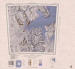
Svaton Peaks
Exploration and name
The Svaton Peaks were mapped by the United States Geological Survey (USGS) from tellurometer surveys and Navy air photos, 1960–62. They were named by the United States Advisory Committee on Antarctic Names (US-ACAN) for Ernest M. Svaton, United States Antarctic Research Program (USARP) ionospheric physicist at McMurdo Station, winter 1963 and 1964.
Location

Svaton Peaks are in the north of the Queen Elizabeth Range at the north end of a block bounded by the Inaccessible Cliffs along the coast of the Nimrod Glacier to the north, the Hamilton Glacier to the west and the Otago Glacier to the east. Nearby features include the Heilman Glacier, Mount Hofmann, Mount Sandved, Mount Dougherty and Mount Cara.
Features
Inaccessible Cliffs
82°33′S 160°48′E / 82.550°S 160.800°E. A line of steep cliffs, interrupted by several glaciers, which form the northern escarpment of the Queen Elizabeth Range. The escarpment borders the southern side of the Nimrod Glacier which is very heavily crevassed. Named by the northern party of the NZGSAE (1961-62) because of their general inaccessibility.
Mount Hofmann
82°40′S 160°36′E / 82.667°S 160.600°E. Snow-covered mountain, 2,000 metres (6,600 ft) high, between the mouths of Hamilton Glacier and Heilman Glacier. Mapped by the USGS from tellurometer surveys and Navy air photos, 1960-62. Named by US-ACAN for Walther F. Hofmann, USARP glaciologist on the Ross Ice Shelf, 1962-63.
Mount Sandved
82°41′S 161°06′E / 82.683°S 161.100°E. Mountain, 2,440 metres (8,010 ft) high, standing 2 nautical miles (3.7 km; 2.3 mi) north of Mount Dougherty in the north part of the Queen Elizabeth Range. Mapped by the USGS from tellurometer surveys and Navy air photos, 1960-62. Named by US-ACAN for Kurt G. Sandved, Information Officer at the Office of Antarctic Programs, National Science Foundation.
Mount Dougherty
82°43′S 161°05′E / 82.717°S 161.083°E. A mountain, 2,790 metres (9,150 ft) high, between Mount Sandved and Mount Cara on the main north–south ridge in the north part of the Queen Elizabeth Range. Mapped by the USGS from tellurometer surveys and Navy air photos, 1960-62. Named by US-ACAN for Ellsworth C. Dougherty, USARP biologist at McMurdo Sound, 1959-60 and 1961-62.
Mount Cara
82°45′S 161°06′E / 82.750°S 161.100°E. Peak, 3,145 metres (10,318 ft) high, standing 4 nautical miles (7.4 km; 4.6 mi) north-northwest of Mount Lysaght. Named by the British Antarctic Expedition, 1907–09.
References
- ^ Alberts 1995, p. 726.
- ^ Nimrod Glacier USGS.
- ^ Alberts 1995, p. 359.
- ^ Alberts 1995, p. 338.
- ^ Alberts 1995, p. 647.
- ^ Alberts 1995, p. 196.
- ^ Alberts 1995, p. 118.
Sources
- Alberts, Fred G., ed. (1995), Geographic Names of the Antarctic (PDF) (2 ed.), United States Board on Geographic Names, retrieved 2023-12-03
 This article incorporates public domain material from websites or documents of the United States Board on Geographic Names.
 - Nimrod Glacier, USGS: United States Geological Survey, retrieved 2024-01-03
 This article incorporates public domain material from websites or documents of the United States Geological Survey.