| Thane Queensland | |||||||||||||||
|---|---|---|---|---|---|---|---|---|---|---|---|---|---|---|---|
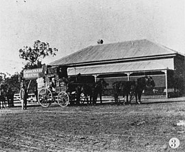
 Carriers Arms Hotel at Thane, 1907 | |||||||||||||||
| Coordinates | 28°09′41″S 151°41′51″E / 28.1613°S 151.6975°E | ||||||||||||||
| Population | 19 (2021 census) | ||||||||||||||
| • Density | 0.499/km (1.29/sq mi) | ||||||||||||||
| Postcode(s) | 4370 | ||||||||||||||
| Area | 38.1 km (14.7 sq mi) | ||||||||||||||
| Time zone | AEST (UTC+10:00) | ||||||||||||||
| Location | |||||||||||||||
| LGA(s) | Southern Downs Region | ||||||||||||||
| State electorate(s) | Southern Downs | ||||||||||||||
| Federal division(s) | Maranoa | ||||||||||||||
| |||||||||||||||
Thane is a rural town and locality in the Southern Downs Region, Queensland, Australia. In the 2021 census, the locality of Thane had a population of 19 people.
Geography
The Cunningham Highway traverses the locality from the south-east (Greymare) to south-west (Karara) passing through the town of Thane which is roughly central within the locality. The South Western railway line also traverses through the locality slightly to the north of the highway from Greymare to the town of Thane and then goes further north than the highway towards Karara before it exits slightly to the north of the highway. The town is served by the Thane railway station (28°09′42″S 151°42′07″E / 28.1617°S 151.7019°E).
Thanes Creek (the watercourse) enters the locality from the south-west (Karara) and exits to the north-west (the locality of Thanes Creek).
The predominant land use is grazing on native vegetation. There is some cropping along Thanes Creek (the watercourse) to the north of the town.
History
The town takes its name from the railway station named on 5 February 1904 after John Thane, a pioneer pastoralist of Ellangowan Run, who drowned in the Condamine River in about 1843.
Thane Provisional School opened on 27 March 1905. On 1 January 1909 it became Thane State School. It closed on 2 May 1925. It was located between Thanes Creek Road and the Cunningham Highway (28°09′39″S 151°41′43″E / 28.1608°S 151.6954°E).
On 27 July 1905 the Queensland Government offered 22 town lots near the Thane railway station, then the terminus of the South Western railway line, ranging in size from 1 to 4 roods (1,000 to 4,000 m). However, there were only five buyers.
St John's Anglican Church opened circa 1909 and closed circa 1968. It was at 230 Thanes Creek Road (28°09′35″S 151°41′48″E / 28.1598°S 151.6967°E). The church was relocated to the Mile End Park, 177 Pratten Street in west Warwick.
On 26 September 1911 the Queensland Government tried to sell more of the town lots.
Demographics
In the 2016 census, the locality of Thane had a population of 27 people.
In the 2021 census, the locality of Thane had a population of 19 people.
Education
There are no schools in Thane. The nearest primary schools are Karara State School in neighbouring Karara to the south-west and Wheatvale State School in Wheatvale to the east. The nearest secondary schools are Allora State School (to Year 10 only) to Allora to the north-east and Warwick State High School (to Year 12) in Warwick to the south-east.
References
- ^ Australian Bureau of Statistics (28 June 2022). "Thane (SAL)". 2021 Census QuickStats. Retrieved 28 February 2023.
- ^ "Thane – town in Southern Downs Region (entry 33805)". Queensland Place Names. Queensland Government. Retrieved 1 September 2020.
- ^ "Thane – locality in Southern Downs Region (entry 45986)". Queensland Place Names. Queensland Government. Retrieved 1 September 2020.
- ^ "Queensland Globe". State of Queensland. Retrieved 6 September 2020.
- ^ "Thane – railway station in Southern Downs Region (entry 33806)". Queensland Place Names. Queensland Government. Retrieved 6 September 2020.
- ^ Queensland Family History Society (2010), Queensland schools past and present (Version 1.01 ed.), Queensland Family History Society, ISBN 978-1-921171-26-0
- ^ "County of Merivale" (Map). Queensland Government. 1923. Archived from the original on 22 February 2020. Retrieved 6 September 2020.
- ^ "CROWN LAND SALES". Warwick Examiner And Times. Vol. 39, no. 4953. Queensland, Australia. 24 June 1905. p. 8. Retrieved 6 September 2020 – via National Library of Australia.
- ^ "Land Matters". Warwick Examiner And Times. Vol. 39, no. 4963. Queensland, Australia. 29 July 1905. p. 2. Retrieved 6 September 2020 – via National Library of Australia.
- ^ "Town of Thane" (Map). Queensland Government. 1969. Archived from the original on 1 January 2018. Retrieved 6 September 2020.
- ^ "Closed Churches". Anglican Church of Southern Queensland. Archived from the original on 3 April 2019. Retrieved 24 February 2019.
- ^ "West Warwick". Anglican Parish of Warwick. Archived from the original on 6 September 2020. Retrieved 6 September 2020.
- ^ "CROWN LAND SALE". Warwick Examiner And Times. No. 4197. Queensland, Australia. 28 August 1911. p. 3. Retrieved 6 September 2020 – via National Library of Australia.
- ^ Australian Bureau of Statistics (27 June 2017). "Thane (SSC)". 2016 Census QuickStats. Retrieved 20 October 2018.
Further reading
- A history of Wheatvale and district : produced to commemorate 100 years of State School Education in Queensland, 1875-1975. 1975. — via State Library of Queensland, includes the districts of Allan, Bony Mountain, Greymare, Pratten, Rodger's Creek, Thane, Thane's Creek and Wheatvale.
