Tierras Nuevas Saliente
| Census | Pop. | Note | %± |
|---|---|---|---|
| 1900 | 776 | — | |
| 1910 | 853 | 9.9% | |
| 1920 | 1,276 | 49.6% | |
| 1930 | 939 | −26.4% | |
| 1940 | 2,457 | 161.7% | |
| 1950 | 2,362 | −3.9% | |
| 1960 | 2,785 | 17.9% | |
| 1970 | 2,856 | 2.5% | |
| 1980 | 3,426 | 20.0% | |
| 1990 | 4,254 | 24.2% | |
| 2000 | 5,786 | 36.0% | |
| 2010 | 6,757 | 16.8% | |
| U.S. Decennial Census 1899 (shown as 1900) 1910-1930 1930-1950 1980-2000 2010 | |||
History
Tierras Nuevas Saliente was in Spain's gazetteers until Puerto Rico was ceded by Spain in the aftermath of the Spanish–American War under the terms of the Treaty of Paris of 1898 and became an unincorporated territory of the United States. In 1899, the United States Department of War conducted a census of Puerto Rico finding that the population of Tierras Nuevas Saliente barrio was 776.
Features
Mar Chiquita Beach, which is considered a dangerous beach, is located in Tierras Nuevas Saliente.
Part of the Laguna Tortuguero is located in Tierras Nuevas Saliente. The eastern part of the lagoon is in Vega Baja, which borders Manatí.
Sectors
Barrios (which are, in contemporary times, roughly comparable to minor civil divisions) in turn are further subdivided into smaller local populated place areas/units called sectores (sectors in English). The types of sectores may vary, from normally sector to urbanización to reparto to barriada to residencial, among others.
Gallery
-
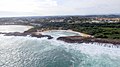 View of Mar Chiquita beach / bay
 -
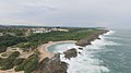
 Los Tubos Beach in Tierras Nuevas Saliente
 -
 Pool and cover at Mar Chiquita Beach Club
 -
 Mar Chiquita in Tierras Nuevas Saliente
.jpg)

.jpg)

See also
References
- ^ "US Gazetteer 2019". US Census. US Government.
- ^ U.S. Geological Survey Geographic Names Information System: Tierras Nuevas Saliente barrio
- ^ Picó, Rafael; Buitrago de Santiago, Zayda; Berrios, Hector H. Nueva geografía de Puerto Rico: física, económica, y social, por Rafael Picó. Con la colaboración de Zayda Buitrago de Santiago y Héctor H. Berrios. San Juan Editorial Universitaria, Universidad de Puerto Rico,1969.
- ^ Gwillim Law (20 May 2015). Administrative Subdivisions of Countries: A Comprehensive World Reference, 1900 through 1998. McFarland. p. 300. ISBN 978-1-4766-0447-3. Retrieved 25 December 2018.
- ^ Puerto Rico: 2010 Population and Housing Unit Counts.pdf (PDF). U.S. Dept. of Commerce, Economics and Statistics Administration, U.S. Census Bureau. 2010.
- ^ "Report of the Census of Porto Rico 1899". War Department Office Director Census of Porto Rico. Archived from the original on July 16, 2017. Retrieved September 21, 2017.
- ^ "Table 3-Population of Municipalities: 1930 1920 and 1910" (PDF). United States Census Bureau. Archived (PDF) from the original on August 17, 2017. Retrieved September 21, 2017.
- ^ "Table 4-Area and Population of Municipalities Urban and Rural: 1930 to 1950" (PDF). United States Census Bureau. Archived (PDF) from the original on August 30, 2015. Retrieved September 21, 2014.
- ^ "Table 2 Population and Housing Units: 1960 to 2000" (PDF). United States Census Bureau. Archived (PDF) from the original on July 24, 2017. Retrieved September 21, 2017.
- ^ Puerto Rico: 2010 Population and Housing Unit Counts.pdf (PDF). U.S. Dept. of Commerce Economics and Statistics Administration U.S. Census Bureau. 2010. Archived (PDF) from the original on 2017-02-20. Retrieved 2019-08-02.
- ^ "Anuario del comercio, de la industria, de la magistratura y de la administración. 1881". Biblioteca Nacional de España (in Spanish). p. 1614. Retrieved 4 April 2023.
- ^ Joseph Prentiss Sanger; Henry Gannett; Walter Francis Willcox (1900). Informe sobre el censo de Puerto Rico, 1899, United States. War Dept. Porto Rico Census Office (in Spanish). Imprenta del gobierno. p. 161.
- ^ "Encaminado un proyecto para declarar reserva ecológica en Mar Chiquita". Primera Hora (in Spanish). March 29, 2019. Archived from the original on September 28, 2019. Retrieved September 28, 2019.
- ^ "Conoce las 11 playas más peligrosas de Puerto Rico [Know the 11 most dangerous beaches in Puerto Rico]". El Nuevo Día (in Spanish). 2018-07-04. Retrieved 2021-05-13.
- ^ "P.L. 94-171 VTD/SLD REFERENCE MAP (2010 CENSUS): Vega Baja Municipio, PR" (PDF). US Census. Washington, DC. 2010. Retrieved 30 December 2022.
- ^ "US Census Barrio-Pueblo definition". factfinder.com. US Census. Archived from the original on 13 May 2017. Retrieved 5 January 2019.
- ^ "Agencia: Oficina del Coordinador General para el Financiamiento Socioeconómico y la Autogestión (Proposed 2016 Budget)". Puerto Rico Budgets (in Spanish). Retrieved 28 June 2019.
- ^ Rivera Quintero, Marcia (2014), El vuelo de la esperanza: Proyecto de las Comunidades Especiales Puerto Rico, 1997-2004 (first ed.), San Juan, Puerto Rico Fundación Sila M. Calderón, ISBN 978-0-9820806-1-0
- ^ "Leyes del 2001". Lex Juris Puerto Rico (in Spanish). Retrieved 24 June 2020.
- ^ "PRECINTO ELECTORAL MANATÍ 022" (PDF). Comisión Estatal de Elecciones (in Spanish). PR Government. 6 August 2019. Retrieved 29 July 2020.
This Manatí, Puerto Rico location article is a stub. You can help Wikipedia by expanding it. |