Tower Butte
Tower Butte is a 5,287-foot (1,611 meter) elevation sandstone summit located south of Lake Powell, in northern Arizona. Tower Butte is a butte composed of Romana and Entrada Sandstones with a Morrison Formation caprock. It is situated 9 miles (14 km) northeast of the town of Page, and 7.5 miles (12.1 km) north of LeChee Rock, on Navajo Nation land, towering over 1,000 feet above the surrounding terrain as an iconic landmark of the area. Precipitation runoff from this feature drains into Lake Powell, which is part of the Colorado River drainage basin. The first ascent of Tower Butte was made October 23, 1994, by Jason Keith and David Insley. However, they were not the first to visit the summit as they reported finding litter from prior helicopter landings. An outfit operating out of Page flies helicopter sightseeing flights which land on the flat top of the butte where tourists have panoramic views of the Glen Canyon National Recreation Area, Lake Powell, and Navajo Mountain.

Climate
According to the Köppen climate classification system, Tower Butte is located in an arid climate zone with hot, very dry summers, and chilly winters with very little snow. It is located in the southern edge of the Great Basin Desert on the Colorado Plateau. Spring and fall are the most favorable seasons to visit.
| Climate data for Page, Arizona | |||||||||||||
|---|---|---|---|---|---|---|---|---|---|---|---|---|---|
| Month | Jan | Feb | Mar | Apr | May | Jun | Jul | Aug | Sep | Oct | Nov | Dec | Year |
| Record high °F (°C) | 64 (18) |
72 (22) |
82 (28) |
91 (33) |
102 (39) |
107 (42) |
109 (43) |
106 (41) |
100 (38) |
93 (34) |
77 (25) |
66 (19) |
109 (43) |
| Mean daily maximum °F (°C) | 43.1 (6.2) |
50.3 (10.2) |
59.5 (15.3) |
68.5 (20.3) |
78.5 (25.8) |
90.2 (32.3) |
95.1 (35.1) |
92.0 (33.3) |
83.5 (28.6) |
69.7 (20.9) |
53.8 (12.1) |
43.7 (6.5) |
69.0 (20.6) |
| Mean daily minimum °F (°C) | 26.3 (−3.2) |
30.4 (−0.9) |
37.0 (2.8) |
43.6 (6.4) |
52.6 (11.4) |
62.3 (16.8) |
68.3 (20.2) |
66.4 (19.1) |
58.4 (14.7) |
46.6 (8.1) |
34.7 (1.5) |
27.1 (−2.7) |
46.1 (7.8) |
| Record low °F (°C) | −11 (−24) |
6 (−14) |
18 (−8) |
25 (−4) |
31 (−1) |
44 (7) |
56 (13) |
46 (8) |
40 (4) |
24 (−4) |
16 (−9) |
1 (−17) |
−11 (−24) |
| Average precipitation inches (mm) | 0.61 (15) |
0.48 (12) |
0.65 (17) |
0.50 (13) |
0.40 (10) |
0.14 (3.6) |
0.58 (15) |
0.69 (18) |
0.66 (17) |
0.99 (25) |
0.56 (14) |
0.48 (12) |
6.74 (171.6) |
| Average snowfall inches (cm) | 2.1 (5.3) |
1.2 (3.0) |
0.2 (0.51) |
0 (0) |
0 (0) |
0 (0) |
0 (0) |
0 (0) |
0 (0) |
0 (0) |
0.5 (1.3) |
1.4 (3.6) |
5.4 (13.71) |
| Average precipitation days (≥ 0.01 in) | 4.5 | 4.0 | 5.2 | 3.5 | 3.2 | 1.7 | 4.6 | 5.2 | 4.5 | 4.3 | 3.2 | 3.9 | 47.8 |
| Average snowy days (≥ 0.1 in) | 0.9 | 0.6 | 0.3 | 0 | 0 | 0 | 0 | 0 | 0 | 0 | 0.2 | 0.6 | 2.6 |
| Source: NOAA | |||||||||||||
Gallery
-
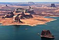
 From the northwest at Alstrom Point
 -

-
 Aerial view from northwest
 -
 From the north
 -
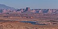
 Tower Butte in upper right corner
 -
.jpg)


See also
References
- ^ "Tower Butte, Arizona". Peakbagger.com. Retrieved 2020-10-11.
- ^ "Tower Butte - 5,282' AZ". listsofjohn.com. Retrieved 2020-10-11.
- ^ "Tower Butte". Geographic Names Information System. United States Geological Survey, United States Department of the Interior. Retrieved 2020-10-11.
- ^ T.C. Chidsey, Jr., D.A. Sprinkel, G.C. Willis, P.B. Anderson Lake Powell Geologic Guide, page 63
- ^ 1995 American Alpine Journal, page 165
- ^ "Climatography of the United States No. 20 (1971–2000)" (PDF). National Oceanic and Atmospheric Administration. 2004. Retrieved 2010-05-31.
External links
Wikimedia Commons has media related to Tower Butte (Navajo Nation).
- Weather forecast: Tower Butte
- Tower Butte Rock Climbing: Mountainproject.com
- Tower Butte helicopter tour: YouTube