Ulrome
Ulrome is a village and civil parish in the East Riding of Yorkshire, England. It is situated approximately 6 miles (9.7 km) north of the town of Hornsea and on the east side of the B1242 road. The parish includes the village of Lissett. Its area is 1,139.535 hectares (2,815.85 acres), in 2011 had a population of 239, a reduction on the 2001 UK census figure of 260.

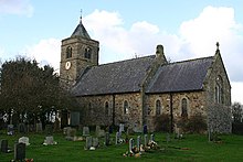
St Andrews Church

The parish church of St Andrew is a Grade II listed building.
Civil parish
Although the civil parish is called "Ulrome" its parish council is called "Lissett & Ulrome Parish Council". On 1 April 1935 Lissett parish was abolished and merged with Ulrome, the parish also gained part of Barmston.
Cables from the offshore 2.4 GW Dogger Bank Wind Farm make landfall to the north of Ulrome.
References
- ^ UK Census (2011). "Local Area Report – Ulrome Parish (1170211280)". Nomis. Office for National Statistics. Retrieved 21 February 2018.
- ^ "2001 Census Area Profile" (PDF). East Riding of Yorkshire Council. 2004. Archived (PDF) from the original on 18 March 2012. Retrieved 8 February 2013.
- ^ UK Census (2001). "Local Area Report – Ulrome Parish (00FB151)". Nomis. Office for National Statistics. Retrieved 4 March 2020.
- ^ Historic England. "Church of St Andrew (1280929)". National Heritage List for England. Retrieved 27 April 2013.
- ^ "Ulrome". Ordnance Survey. Retrieved 5 February 2021.
- ^ "Home". Lissett & Ulrome Parish Council. Retrieved 5 February 2021.
- ^ "Relationships and changes Ulrome Tn/CP through time". A Vision of Britain through Time. Retrieved 5 February 2021.
- ^ "Onshore". Dogger Bank Wind Farm. Retrieved 1 October 2021.
- Gazetteer — A–Z of Towns Villages and Hamlets. East Riding of Yorkshire Council. 2006. p. 11.
External links
Wikimedia Commons has media related to Ulrome.
- Historic England. "St Andrew's Church (1280929)". National Heritage List for England.
- Ulrome in the Domesday Book