Wahibah Desert
Geology

The desert was formed during the Quaternary period as a result of the forces of south-west blowing monsoon and the northern shamal trade wind, coming in from the east. Based on the types of dunes found in the area, it is divided into the high, or upper, Wahiba and low Wahiba. The upper area contains mega-ridge sand systems on a north–south line that are believed to have been formed by monsoon. The dunes of the north, formed at some point after the last regional glaciation, measure up to 100 meters (330 ft) high, with peaks accumulating in the areas just beyond the strongest wind speeds, where declining velocity wind deposited sand. The north and west boundaries of the desert are delineated by the fluvial systems Wadi Batha and Wadi Andam. Beneath the surface sands are an older layer of cemented carbonate sand. Alluvium deposits believed to have originated from the Wadi Batha during the Paleolithic era have been disclosed in the central desert 200 meters (660 ft) beneath the interdune surface. Wind erosion is believed to have contributed to the existence of a nearly level plain in the southwest.
Inhabitants
The area is occupied by Bedouins who congregate at Al-Huyawah, an oasis near the border of the desert, between June and September to gather dates. Tribes present in the area at the time of the Royal Geographical Society expedition included, predominantly, Al Wahiba (or Yal Wahiba) for whom the region is named, Al-Amr, Al-Bu-Isa, Hikman, Hishm and Janaba.
Gallery
-
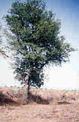 Ghaf trees
(Prosopis cineraria) -
 Wahiba Sands
 -

-

-
 Vehicles on the dunes near the Eastern Hajar Mountains

.jpg)
.jpg)
.jpg)
.jpg)
See also
References
- ^ "Travel to Oman, Visit Muscat through Oman Travel Guide for Sultanate of Oman Adventure". Ministry of Tourism, Sultanate of Oman. Archived from the original on 6 November 2014. Retrieved 6 November 2014.
- ^ "The Wahiba Sands". Rough Guides. Retrieved 2014-08-16.
- ^ "Sharqiya (Wahiba) Sands, Oman - Travel Guide, Info & Bookings – Lonely Planet". Lonelyplanet.com. Retrieved 2013-06-09.
- ^ Alsharan, 615.
- ^ Darke and Shields, 216.
- ^ Alsharan, 216.
- ^ Alsharan, 215, 279, 280.
- ^ Pease, Patrick P.; Gregory D. Bierly; Vatche P. Tchakerianc; Neil W. Tindaled (September 1999). "Mineralogical characterization and transport pathways of dune sand using Landsat TM data, Wahiba Sand Sea, Sultanate of Oman". Geomorphology. 29 (3–4): 235–249. doi:10.1016/S0169-555X(99)00029-X.
The Wahiba Sand Sea has been previously divided into upper (north and higher in elevation) and lower (south and lower in elevation) portions, based on dune morphology.
- ^ Alsharan, 119, 316.
- ^ Cooke et al., 346.
- ^ Alsharhan, xii.
- ^ Alsharan, 282.
- ^ Cooke et al., 305.
- ^ Webster, Roger (1991). "Notes on the Dialect and Way of Life of the Āl Wahība Bedouin of Oman". Bulletin of the School of Oriental and African Studies, University of London. 54 (3). Cambridge University Press: 473–485. doi:10.1017/S0041977X00000835. JSTOR 619056.
Sources
- Alsharhan, A. S.; IGCP Project 349 (1998). Quaternary Deserts and Climatic Change: Proceedings of the International Conference on Quaternary Deserts and Climatic Change : Al Ain, United Arab Emirates, 9–11 December 1995. Taylor & Francis. ISBN 90-5410-597-6.
{{cite book}}: CS1 maint: numeric names: authors list (link) - Cooke, Ronald U.; Andrew Warren; Andrew Goudie (1993). Desert Geomorphology. Taylor & Francis. ISBN 1-85728-017-2.
- Darke, Diana; Sandra Shields (2006). Oman: The Bradt Travel Guide. Bradt Travel Guides. pp. 214–217. ISBN 1-84162-168-4.