Wat Mangkon MRT Station
Location
The station is situated right in the middle of the business district of the Chinese-Thais (otherwise known as Bangkok's Chinatown), along with Charoen Krung Road in the vicinity of Plaeng Nam Intersection, and close to Wat Mangkon Kamalawat (otherwise known as Wat Mangkon, or Leng Noei Yi, according to the Teochew dialect), which is a district of unique community culture tied to the history of the Chinese descendants.
It is overlaps between Samphanthawong Subdistrict, Samphanthawong District with Pom Prap Subdistrict, Pom Prap Sattru Phai District, Bangkok.
In addition to being close to Wat Mangkon Kamalawat, the station is also situated near the Mo Mi Junction, Trok Texas, Odeon Circle, Phlapphla Chai Police Station, Poh Teck Tung Foundation, 22 July Circle, and the New Yaowarat Market etc.
Design
Inside station is designed with Sino-Portuguese architecture in mind in order drawn from Wat Mangkon Kamalawat, the interior is decorated with murals of Chinese dragons and water lilies, and to correspond with the name of the station (Wat Mangkon Kamalawat meaning "Temple of Water Lily Dragon"); the ceiling along the descent into head residing inside the station. These were done through the use of red and gold colours, which are all colours of auspiciousness according to Chinese beliefs.
The station is part of Nescafe Blend and Brew's Interactive Art Station Program in commemoration of its 46 years of business in Thailand.

Station layout
| G Ground floor |
Street level | Bus stop, Yaowarat Road, Wat Mangkon Kamalawat |
| B1 Concourse |
Concourse Level | Exits 1–3, and Ticket Vending Machines |
| B2 Platform |
Platform 2 | Blue towards Tha Phra via Bang Sue (Hua Lamphong) |
| Side platform, doors will open on the right | ||
| B4 Platform |
Platform 1 | Blue towards Lak Song (Sam Yot) |
| Side platform, doors will open on the left | ||
Gallery
-
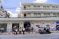 Front of station in Pom Prap side
 -
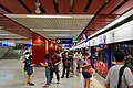
 The vending machines
 -
 Platform 2 to Tha Phra station (via Bang Sue station)
 -
 Entry 1 on Plaeng Nam Road
 -
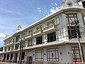 The station building on the Samphanthawong side (next to the Plaeng Nam Road)
 -
 Dragon motif
 -
 The ceiling has also been designed such as if the passengers are walking inside a dragon's belly
 -
 Platform while under construction
.jpg)


.jpg)


References