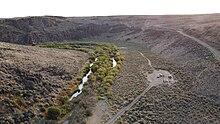
West Little Owyhee River
The river begins east of McDermitt and flows east by Deer Flat and into Louse Canyon. Near Twin Buttes, it turns sharply north, still in Louse Canyon, which it follows through the Owyhee Desert all the way to the Owyhee River in Owyhee Canyon. The entire river is protected as part of the National Wild and Scenic Rivers System.
Overseen by the Bureau of Land Management, the river offers fishing for smallmouth bass and trout, and the canyon area is scenic. Dispersed camping is allowed, although the watershed has no developed parks or campsites. Other forms of recreation include hiking, backpacking, hunting, picnicking, and biking.

Named tributaries from source to mouth are Lake Fork West Owyhee River, Jack Creek, Little Spring Creek, and Toppin Creek, which all enter from the right had side bank. Further downstream, Cave Creek enters from the left.
See also
References
- ^ "West Little Owyhee River". Geographic Names Information System (GNIS). United States Geological Survey (USGS). November 28, 1980. Retrieved February 28, 2011.
- ^ McArthur, Lewis A.; Lewis L. McArthur (2003) [1928]. Oregon Geographic Names (7th ed.). Portland: Oregon Historical Society Press. p. 735. ISBN 0-87595-277-1.
- ^ Source elevation derived from Google Earth search using GNIS source coordinates.
- ^ Palmer, Tim (2014). Field Guide to Oregon Rivers. Corvallis: Oregon State University Press. p. 270. ISBN 978-0-87071-627-0.
- ^ U.S. Geological Survey. National Hydrography Dataset high-resolution flowline data. The National Map, accessed May 3, 2011
- ^ "Watershed Boundary Dataset". USDA, NRCS, National Cartography and Geospatial Center. Retrieved September 4, 2010.
- ^ Oregon Atlas & Gazetteer (Map) (1991 ed.). DeLorme Mapping. § 75. ISBN 0-89933-235-8.
- ^ "West Little Owyhee River, Oregon". National Wild and Scenic Rivers System. Retrieved December 22, 2015.
- ^ "Wild and Scenic Rivers Act, Appendix B" (PDF). United States Forest Service. p. B-25. Retrieved March 2, 2011.
- ^ "West Little Owyhee Wild & Scenic River, Oregon". Public Lands Interpretive Association. Retrieved March 2, 2011.
- ^ "United States Topographic Map". United States Geological Survey. Retrieved December 22, 2015 – via Acme Mapper.