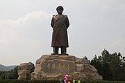
Wushi, Xiangtan
Administrative division
As of 2017, the town is divided into thirteen villages and one community, the following areas:
- Waziping Community (瓦子坪社区)
- Daming (大明村)
- Shuangmiao (双庙村)
- Wushi (乌石村)
- Pingshan (平山村)
- Yuechongqiao (岳冲桥村)
- Hualong (华龙村)
- Tianlong (天龙村)
- Zhongxing (众兴村)
- Jinxiu (锦绣村)
- Shifeng (石峰村)
- Wushifeng (乌石峰村)
- Jingquan (景泉村)
- Simei (四美村)
History
In the Qing dynasty (1644–1911), it belonged to Yisu Township (易俗乡).
In 1935, it came under the jurisdiction of the 8th District.
After the establishment of the Communist State, in 1950, it was under the jurisdiction of the 6th District. In 1958, the townships of Baituo (白托乡), Wushi and Jingquan (景泉乡) merged to form the Weiguo People's Commune (卫国人民公社). In 1995, former Wushi Township and Jingquan Township merged to form Wushi Township. In 1998 it was upgraded to a town. On November 17, 2017, it was listed among the fifth group of "National Civilized Villages and Towns" by the Central Guidance Commission on Building Spiritual Civilization of the Central Committee of the Chinese Communist Party. On September 19, 2019, it was designated as a "National Health Town" (国家卫生镇) by the National Patriotic Health Campaign Committee.
Geography
It lies at the southwestern of Xiangtan County, bordering Xiangxiang to the west, Paitou Township to the south, Shitan Town to the north, and Jinshi Township to the east.
The town enjoys a subtropical humid monsoon climate, enjoying four distinct seasons and abundant precipitation. The average annual temperature is 18 °C (64 °F) and total annual rainfall is 1,350-millimetre (53 in).
Wushi Peak (乌石峰) is the scenic spot in the town, which, at 377.5 metres (1,239 ft) above sea level. It is one of the 72 peaks of Heng Mountains.
Economy
Tea, corn, daylily and peanut are important to the economy.
Demographics
| Year | Pop. | ±% |
|---|---|---|
| 2000 | 37,583 | — |
| 2017 | 27,143 | −27.8% |
As of 2017, the National Bureau of Statistics of China estimates the township's population now to be 27,143.
Attractions
The Former Residence of Peng Dehuai, was built in Qing dynasty, also a scenic spot in the town.
Culture
Huaguxi is the most influence local theater.
Transport
The G0421 Xuchang–Guangzhou Expressway is a north–south highway in the town.
Celebrity
- Peng Dehuai, a prominent Chinese Communist military leader, and served as China's Defense Minister from 1954 to 1959.
Gallery
-
Bronze statue of Peng Dehuai
-
Peng Dehuai's house
-
Tomb of Peng Dehuai
-
Memorial Hall of Peng Dehuai
References
- ^ Chen Canhui (陈灿辉); Feng Jieling (冯杰灵) (16 October 2020). 湘潭县乌石镇:秋日稻花香 颗粒归仓抢收忙. 163.com (in Chinese). Retrieved 24 February 2021.
- ^ Lu Hong (路弘) (17 November 2017). (受权发布)第五届全国文明城市、文明村镇、文明单位和第一届全国文明校园名单. wenming.cn (in Chinese). Archived from the original on 24 January 2019. Retrieved 24 November 2021.
- ^ Gu Ju (谷桔) (19 September 2019). 厉害!湘潭县乌石镇顺利通过国家卫生镇技术评估. thepaper.cn (in Chinese). Retrieved 24 February 2021.
- ^ Jiao Ju (焦炬); Li yaoxiang (李耀湘); Xu Kai (许凯) (10 June 2017). 走进大美湘潭、畅游特色小镇:元帅故里 田园乌石. 163.com (in Chinese). Retrieved 24 February 2021.
- ^ Zhang Hong, ed. (2018). 中国分省系列地图册:湖南 [Maps of Provinces in China: Hunan] (in Chinese). Xicheng District, Beijing: Sino Maps Press. pp. 50–51. ISBN 978-7-5031-8949-4.


