Arrecife
Arrecife is located south of Teguise and east of San Bartolomé, and is bordered by the Atlantic Ocean to its southeast. It is a port town, served by ferries to the other Canary Islands, Europe, and Africa. The LZ1 road connects Arrecife to the northeast of the island, the LZ2 road connects it to the southwest, and the LZ3 road serves as the city's beltway. The tallest building in Lanzarote is the Arrecife Gran Hotel, which is located on the seafront alongside the harbour.
History
The earliest records of Arrecife date from the fifteenth century when it was a small fishing settlement. The name, given then as Arrecifes, refers to the black volcanic reefs behind which boats could hide, protected from sudden pirate attacks.
Towards the end of the sixteenth century the settlement began to grow in response to a need for accommodation and warehousing to support growing trade between the old and new worlds. The first church was constructed at this time, consecrated to the first bishop of Arrecife, San Ginés. Growing prosperity increased the attractiveness of the town as a pirate target: in 1571 a pirate named Dogan plundered and almost completely destroyed the little port town.
In 1964 Arrecife became the site of Lanzarote's first sea-water desalination plant.
Climate
Lanzarote has a hot desert climate (BWh) according to the Köppen climate classification. The little precipitation is concentrated in the winter months.
| Climate data for Lanzarote Airport (1981-2010) | |||||||||||||
|---|---|---|---|---|---|---|---|---|---|---|---|---|---|
| Month | Jan | Feb | Mar | Apr | May | Jun | Jul | Aug | Sep | Oct | Nov | Dec | Year |
| Record high °C (°F) | 27.9 (82.2) |
29.0 (84.2) |
32.7 (90.9) |
36.3 (97.3) |
42.6 (108.7) |
40.7 (105.3) |
42.9 (109.2) |
43.6 (110.5) |
40.5 (104.9) |
37.1 (98.8) |
34.2 (93.6) |
27.5 (81.5) |
43.6 (110.5) |
| Mean daily maximum °C (°F) | 20.7 (69.3) |
21.3 (70.3) |
22.9 (73.2) |
23.5 (74.3) |
24.6 (76.3) |
26.3 (79.3) |
28.2 (82.8) |
29.1 (84.4) |
28.6 (83.5) |
26.7 (80.1) |
24.2 (75.6) |
21.8 (71.2) |
24.8 (76.6) |
| Daily mean °C (°F) | 17.4 (63.3) |
17.9 (64.2) |
19.0 (66.2) |
19.6 (67.3) |
20.8 (69.4) |
22.6 (72.7) |
24.3 (75.7) |
25.2 (77.4) |
24.7 (76.5) |
23.0 (73.4) |
20.7 (69.3) |
18.6 (65.5) |
21.1 (70.0) |
| Mean daily minimum °C (°F) | 14.0 (57.2) |
14.3 (57.7) |
15.0 (59.0) |
15.7 (60.3) |
16.8 (62.2) |
18.8 (65.8) |
20.4 (68.7) |
21.2 (70.2) |
20.8 (69.4) |
19.4 (66.9) |
17.2 (63.0) |
15.4 (59.7) |
17.4 (63.3) |
| Record low °C (°F) | 8.0 (46.4) |
9.0 (48.2) |
8.3 (46.9) |
9.5 (49.1) |
11.5 (52.7) |
12.4 (54.3) |
15.4 (59.7) |
16.6 (61.9) |
15.5 (59.9) |
12.0 (53.6) |
10.9 (51.6) |
9.0 (48.2) |
8.0 (46.4) |
| Average rainfall mm (inches) | 16.5 (0.65) |
18.2 (0.72) |
12.5 (0.49) |
5.2 (0.20) |
1.5 (0.06) |
0.1 (0.00) |
0.0 (0.0) |
0.5 (0.02) |
2.2 (0.09) |
9.9 (0.39) |
14.7 (0.58) |
29.3 (1.15) |
110.6 (4.35) |
| Average rainy days (≥ 1.0 mm) | 3 | 3 | 2 | 1 | 0 | 0 | 0 | 0 | 0 | 2 | 3 | 4 | 18 |
| Mean monthly sunshine hours | 203 | 201 | 241 | 255 | 297 | 292 | 308 | 295 | 248 | 235 | 207 | 196 | 2,978 |
| Source: Agencia Estatal de Meteorología | |||||||||||||
Historical population
|
| |||||||||||||||||||||||||||
| Source: Centro de Datos, Cabildo de Lanzarote | ||||||||||||||||||||||||||||
Economy
The Port of Arrecife is the main port facility for Lanzarote and the second busiest in the Canary Islands in terms of passengers. It handles passenger ferries, cruise ships, and ro-ro cargo, but also bulk, breakbulk, containers, and liquid bulk, and has a large fishing port.
Communities
- Urbanización Playa Honda (subdivision), south
Assets of Cultural Interest
The real estate properties of Arrecife registered in the Register of Assets of Cultural Interest are:
- Casa de los Arroyo
- Castillo de San Gabriel
- Castillo de San José
- Iglesia Matriz de San Ginés Obispo
- Fachada del edificio Segarra
- Headquarter of the Island Council of Lanzarote
- Salinas de Naos
- Salinas de Bufona
Sites of interest
- Playa Reducto, Arrecife's town beach
- Castillo de San José, 18th-century fortress that now houses a collection of modern art
- Puente de Las Bolas, bridge leading to the Castillo de San Gabriel
- Charco de San Ginés, man-made lagoon used by fishermen
Gallery
-
 Church
 -
 The Gran Hotel Arrecife
 -
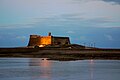 Castle of San Gabriel


See also
References
- ^ Instituto Canario de Estadística, area
- ^ Municipal Register of Spain 2018. National Statistics Institute.
- ^ "Arrecife - Población: inmigrantes, emigrantes y otros datos sobre los habitantes de cada municipio". www.epdata.es. Retrieved 2021-05-15.
- ^ "Carreteras insulares de Lanzarote (2007)". www.datosdelanzarote.com. Retrieved 2021-05-16.
- ^ González-Morales, Alejandro; Ramón-Ojeda, Antonio Ángel (2019-06-14). "La desalación de agua de mar en las Canarias Orientales: los casos de Lanzarote y Fuerteventura". Agua y Territorio / Water and Landscape (in Spanish) (13): 15–26. doi:10.17561/at.13.3722. hdl:10553/58386. ISSN 2340-7743.
- ^ "Arrecife, Spain Köppen Climate Classification (Weatherbase)".
- ^ "Guía resumida del clima en España (1981-2010)". Archived from the original on 2012-11-18.
- ^ "Población de derecho de Lanzarote según municipio. Evolución (1996-2019)" [Legal population of Lanzarote by municipality. Evolution (1996-2019)] (in Spanish). Centro de Datos, Cabildo de Lanzarote. Retrieved 2019-07-16.
- ^ "Port of Arrecife". Puertos de Las Palmas. Retrieved 11 April 2021.
- ^ "Port of Arrecife, Spain". www.findaport.com. Shipping Guides Limited. Retrieved 11 April 2021.
External links
 Media related to Arrecife at Wikimedia Commons
 Arrecife travel guide from Wikivoyage
- Things to do in Arrecife
Places adjacent to Arrecife | ||||||||||||||||
|---|---|---|---|---|---|---|---|---|---|---|---|---|---|---|---|---|
| ||||||||||||||||
Island capitals of the Canary Islands | ||
|---|---|---|
| Province of Santa Cruz de Tenerife | ||
| Province of Las Palmas | ||
| International | |
|---|---|
| National | |
| Geographic | |