Bagulin
Bagulin is well-known for its broom-making industry, particularly its high-quality soft brooms.
Etymology
The name Bagulin originates from a local folklore about Bago and Ulin. According to folklore, Bago, an Igorot highlander, traveled westward from the uplands after observing a bluish crystal near the coast. Upon reaching the area, he encountered Ulin, a lowland maiden, who was struggling in the waves. Displaying courage, Bago rescued her, and the two fell in love.
Despite their cultural differences and the disapproval of Ulin's family, Bago and Ulin eloped and settled in the area now known as Bagulin. They had a son, whom they named Bagulin, combining their names as a symbol of their union.
Bagulin grew up to become the first chieftain of the community, then referred to as "Allabok." His leadership was characterized by tribal victories and efforts to unify the local population, earning him widespread respect. After his death, the settlement was renamed Bagulin in his honor, with the approval of Spanish authorities.
The name Bagulin embodies both the romantic origins of its founders and the enduring legacy of leadership and resilience that shaped the community's early history.
History
Early History
Bagulin traces its origins to the settlements of the Igorot people, predominantly the Kankanaeys, who were known for their prosperous agricultural practices and vibrant animistic culture, reflecting their profound ancestral heritage. By the mid-18th century, the area that would become Bagulin formed part of the township of Allabok, located on the moderate slopes of the mountains overlooking the South China Sea.
The community actively engaged in trade, exchanging commodities such as gold, rice, jars, wax, and woven products with neighboring groups, including the Ilocanos, Ibalois, and Pangasinans, as well as distant traders from Maritime Southeast Asia, Japan and China.
The town derives its name from a tribal leader named Bagulin, who played a pivotal role in a tribal war involving Allabok. Under Bagulin’s leadership, the community achieved several victories, and he was revered as a noble and respected leader until his death. In his honor, the residents, with the concurrence of Spanish authorities, named the town after him.
Spanish Colonial Period
During the Spanish colonization in the 1700s, portions of what is now Bagulin and Naguilian were under the jurisdiction of Bauang and governed through the encomienda system. This system entrusted local inhabitants to Spanish encomenderos, friars, and native nobles in exchange for tribute and governance.
By February 1839, Naguilian became a town, and parts of Bagulin, which were predominantly inhabited by Igorots, were originally part of Naguilian under the province of Pangasinan.
American Colonial Period
The significant transformation of Bagulin began in 1903 during the American colonial period, when a parliamentary government was instituted. This change ushered in the establishment of institutional facilities and the introduction of formal education. A bamboo community hall with a cogon grass roof was constructed, symbolizing the progress of the community. During this period, Bagulin was placed under the jurisdiction of the Mountain Province, a sub-province of Benguet. The community was subsequently relocated to Picdel, a narrow valley strip along the Naguilian-Bagulin River, which provided a more suitable environment for settlement and development.
In 1918, an agreement between Governor Guzman of the Mountain Province and Governor Pio Ancheta of La Union designated Bagulin as a municipal district of Burgos within La Union, marking a significant change in its governance structure. In 1922, the Mountain Province officially relinquished Bagulin to La Union, though it continued to function as a municipal district for several more decades.
The administrative landscape of Bagulin changed further in 1928 when the community center was relocated to a nearby settlement known as Suyo, which is now the present-day Poblacion. The former community center, named Nangalisan (meaning “an abandoned place” in Ilocano), was left behind as settlers from Naguilian, primarily Ilocanos, moved in to improve Suyo. During this period, a bamboo chalet was constructed to serve as the administrative hall, housing a simple governance structure that comprised a mayor, a secretary-treasurer, and a policeman. These developments laid the foundation for future local governance and community organization.
Full Municipal Status
Bagulin’s long-awaited transition to full municipal status occurred on June 25, 1963, when it was officially converted into a regular municipality by virtue of Executive Order No. 42, issued by President Diosdado Macapagal. This milestone recognized Bagulin as the 20th municipality of La Union, solidifying its place in the province's history. The transition marked a new chapter in Bagulin’s development, enabling the town to pursue further growth and self-governance as a thriving municipality within La Union.
Geography

Bagulin is a landlocked municipality located in the easternmost part of the province of La Union, Philippines. It is geographically bordered by several towns: to the north by San Gabriel, to the northwest by San Juan, to the west by City of San Fernando, to the southeast by Naguilian, to the south by Burgos, and to the east by Kapangan in the province of Benguet.
The municipality is characterized by its predominantly hilly and mountainous terrain, which is heavily forested. The Balili (Naguilian) River traverses the town, providing a natural waterway that supports its agricultural and ecological landscape. Bagulin is also home to several natural attractions, including Loslosi Falls and Cardiz Spring, as well as numerous creeks and streams.

Accessibility to Bagulin is primarily through the Naguilian-Bagulin Road or F. Ortega Highway in San Fernando City, which connects it to neighboring towns. The town is serviced by various modes of transportation and can be reached via Naguilian.
Bagulin is situated approximately 21 kilometers (13 miles) from the provincial capital of City of San Fernando and around 290 kilometers (180 miles) from Metro Manila.
Barangays
Bagulin is divided into 10 barangays, each consisting of puroks, and some also include sitios, with most classified as rural based on the 2020 census. Each barangay is governed by a Barangay Chairman along with its Councilors. The youth are represented by the Sangguniang Kabataan, with its Councilor responsible for addressing youth-related concerns.
- Alibangsay
- Baay
- Cambaly
- Cardiz
- Dagup
- Libbo
- Suyo (Poblacion)
- Tagudtud
- Tio-angan
- Wallayan
Climate
The town has a Type I climate according to the Köppen Climate Classification, characterized by distinct wet and dry seasons. The wet season usually begins in mid-May and lasts until the end of October, while the dry season spans from December to early May. During the wet season, the Southwest Monsoon (SWM) brings heavy rainfall, whereas the Northeast Monsoon (NEM) contributes to relatively dry conditions as it passes over the Cordillera Mountains.
| Climate data for Bagulin, La Union | |||||||||||||
|---|---|---|---|---|---|---|---|---|---|---|---|---|---|
| Month | Jan | Feb | Mar | Apr | May | Jun | Jul | Aug | Sep | Oct | Nov | Dec | Year |
| Mean daily maximum °C (°F) | 30 (86) |
31 (88) |
32 (90) |
33 (91) |
32 (90) |
31 (88) |
30 (86) |
29 (84) |
30 (86) |
31 (88) |
31 (88) |
30 (86) |
31 (88) |
| Mean daily minimum °C (°F) | 21 (70) |
22 (72) |
23 (73) |
25 (77) |
26 (79) |
25 (77) |
25 (77) |
25 (77) |
25 (77) |
24 (75) |
23 (73) |
21 (70) |
24 (75) |
| Average precipitation mm (inches) | 42 (1.7) |
48 (1.9) |
74 (2.9) |
110 (4.3) |
269 (10.6) |
275 (10.8) |
362 (14.3) |
325 (12.8) |
330 (13.0) |
306 (12.0) |
126 (5.0) |
61 (2.4) |
2,328 (91.7) |
| Average rainy days | 11.2 | 12.0 | 17.1 | 21.2 | 27.1 | 26.8 | 28.1 | 27.0 | 26.0 | 24.5 | 17.7 | 12.4 | 251.1 |
| Source: Meteoblue | |||||||||||||
Demographics
| Year | Pop. | ±% p.a. |
|---|---|---|
| 1918 | 2,419 | — |
| 1939 | 3,584 | +1.89% |
| 1948 | 3,101 | −1.60% |
| 1960 | 4,407 | +2.97% |
| 1970 | 5,338 | +1.93% |
| 1975 | 6,423 | +3.78% |
| 1980 | 7,009 | +1.76% |
| 1990 | 9,418 | +3.00% |
| 1995 | 10,780 | +2.56% |
| 2000 | 11,857 | +2.06% |
| 2007 | 12,521 | +0.75% |
| 2010 | 12,590 | +0.20% |
| 2015 | 13,456 | +1.27% |
| 2020 | 14,428 | +1.38% |
| Source: Philippine Statistics Authority | ||
Based on the 2020 census data from the Philippine Statistics Authority, the municipality of Bagulin has a total population of 14,428 individuals. This equates to a population density of 130 residents per square kilometer (340 per square mile), with an average density of 159.3 inhabitants per square kilometer. The population is distributed between 7,564 males and 6,861 females, revealing a slightly higher proportion of males in the area.
In terms of age structure, the population is broken down into three major groups: 27.7% (4,002 individuals) belong to the younger age group of 0–14 years old, indicating a relatively youthful population. The majority of the population, 65.4% (9,438 people), fall within the working-age group of 15–64 years old, which is a significant proportion of the population and reflects the labor force potential of the municipality. Meanwhile, the elderly population aged 65 and above accounts for 6.8% (985 individuals), a smaller yet important demographic group. Notably, the age group with the highest concentration is 10–19 years old, comprising 2,697 individuals, indicating a substantial number of adolescents and young adults in Bagulin.
Ethnically, Bagulin is predominantly home to Indigenous Peoples (IPs), specifically the Bago and Kankanaey groups, who make up 85% of the total population, amounting to 11,539 individuals. This cultural distinction highlights the deep-rooted indigenous heritage and traditions within the community. The languages commonly spoken in Bagulin include Iloco and Kankanaey, reflecting the cultural diversity and multilingual nature of the municipality.
In terms of religion, Roman Catholicism is the dominant faith in the area, underscoring the strong Catholic influence on the town’s social and cultural life. The religious landscape is an integral aspect of the town's identity, shaping community events, traditions, and social practices.
The municipality has 13 public elementary schools and 5 public secondary schools
Public Elementary Schools in Bagulin:
- Alibangsay Elementary School
- Baay Integrated School
- Bagulin Central Elementary School
- Cambaly Elementary School
- Cardiz Elementary School
- Dagup Integrated School
- Libbo Elementary School
- Lower Wallayan Elementary School
- Papayo Elementary School
- Pila Elementary School
- Sinabugan Elementary School
- Tagudtud Elementary School
- Tio-angan Elementary School
- Upper Wallayan Elementary School
Public Secondary Schools in Bagulin:
Economy
Agriculture
Bagulin’s economy is primarily driven by agriculture, with residents cultivating a variety of crops such as rice, corn, vegetables, root crops, and fruit-bearing trees like mangoes and bananas. The town’s cooler climate also supports the growth of highland crops, including cabbage, carrots, snap beans, potatoes, and taro. Livestock farming, particularly poultry, pigs, and cattle, supplements local incomes, further diversifying the town’s agricultural base.
Industries
Bagulin is renowned for its soft broom industry, producing brooms made from tiger grass, which is abundant in the town. This product has gained recognition as a local specialty and serves as the town’s "One Town, One Product" (OTOP). In addition to soft brooms, Bagulin is also known for producing tapuy, a traditional rice wine, as well as basketry made from bamboo and wood carving. These industries highlight the town’s rich craftsmanship and agricultural heritage, contributing to its unique cultural identity and local economy.
Tourism
The town's scenic natural landscapes, including the Kudal Peoples' Park, Cardiz Natural Spring and Loslosi Falls, have spurred the growth of eco-tourism, attracting visitors for hiking and other outdoor activities. In 1977, Allabok, Bagulin, where burial caves and hanging coffins are found, was declared a National Cultural Treasure, further adding to the town's cultural significance. These natural and historical landmarks play an important role in Bagulin’s growing tourism sector.
Infrastructure
On the infrastructure front, Bagulin excels in Education and Local Government Unit (LGU) Investment, both ranking 9th, showcasing strong local government support in these areas. Its Health Infrastructure also ranks 14th, highlighting another strength. However, the town faces challenges related to Distance to Ports (142nd) and Availability of Basic Utilities (222nd), which can limit access to essential services and hinder business growth and overall development.
Performance
Poverty incidence of Bagulin
10
20
30
40
50
2006
49.50 2009
35.07 2012
27.60 2015
12.96 2018
5.5 2021
16.21 Source: Philippine Statistics Authority |
According to the 2024 DTI Cities and Municipalities Competitive Index, Bagulin demonstrates a mixed performance in both economic and infrastructure indicators. In Economic Dynamism, the town ranks well, securing the 20th spot for Employment Generation among 5th to 6th class municipalities, indicating effective job creation. It also ranks moderately in Cost of Living (50th), reflecting affordability. However, Bagulin ranks lower in Active Establishments (161st) and Local Economy Growth (99th), suggesting fewer businesses and slower economic expansion.
Government
Local government
Bagulin, belonging to the second congressional district of the province of La Union, is governed by a mayor designated as its local chief executive and by a municipal council as its legislative body in accordance with the Local Government Code. The mayor, vice mayor, and the councilors are elected directly by the people through an election which is being held every three years.
Elected officials
| Position | Name |
|---|---|
| Congressman | Sandra Y. Eriguel |
| Mayor | Virgilio C. Flor |
| Vice-Mayor | Jaime A. Lictao |
| Councilors | Ferdinand D. Tumbaga |
| Eduardo R. Compas | |
| Warton E. Sacpa | |
| Joel E. Nang-is | |
| Natalia R. Mazon | |
| Robeo B. Sallatic | |
| Prescila D. Dumaguing | |
| Juanito C. Badbadaoi |
National Cultural Treasure
The town is home to one National Cultural Treasure of the Philippines, which is the Burial Caves of Sitio Alabok in Barangay Cambaly.
Gallery
-
 Municipal hall
 -
 Police station
 -
 Landscape
 -
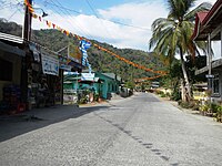 Street view
 -
 Welcome Arch
 -
 Town Proper
 -
 Tiger grass, used for making soft brooms
 -
 Town Plaza
 -
 Bagulin River


References
- ^ Municipality of Bagulin | (DILG)
- ^ "2015 Census of Population, Report No. 3 – Population, Land Area, and Population Density" (PDF). Philippine Statistics Authority. Quezon City, Philippines. August 2016. ISSN 0117-1453. Archived (PDF) from the original on May 25, 2021. Retrieved July 16, 2021.
- ^ Census of Population (2020). "Region I (Ilocos Region)". Total Population by Province, City, Municipality and Barangay. Philippine Statistics Authority. Retrieved 8 July 2021.
- ^ "PSA Releases the 2021 City and Municipal Level Poverty Estimates". Philippine Statistics Authority. 2 April 2024. Retrieved 28 April 2024.
- ^ Provincial Government of La Union. "Municipality of Bagulin History". launion.gov.ph.
- ^ "Executive Order No. 42". lawphil.net. Retrieved 2025-01-05.
- ^ "Province: La Union". PSGC Interactive. Quezon City, Philippines: Philippine Statistics Authority. Retrieved 12 November 2016.
- ^ "Bagulin: Average Temperatures and Rainfall". Meteoblue. Retrieved 26 April 2020.
- ^ Census of Population (2015). "Region I (Ilocos Region)". Total Population by Province, City, Municipality and Barangay. Philippine Statistics Authority. Retrieved 20 June 2016.
- ^ Census of Population and Housing (2010). "Region I (Ilocos Region)" (PDF). Total Population by Province, City, Municipality and Barangay. National Statistics Office. Retrieved 29 June 2016.
- ^ Censuses of Population (1903–2007). "Region I (Ilocos Region)". Table 1. Population Enumerated in Various Censuses by Province/Highly Urbanized City: 1903 to 2007. National Statistics Office.
- ^ "Province of La Union". Municipality Population Data. Local Water Utilities Administration Research Division. Retrieved 17 December 2016.
- ^ "Bagulin (Municipality, Philippines) - Population Statistics, Charts, Map and Location". www.citypopulation.de. Retrieved 2024-10-10.
- ^ Provincial Government of La Union. "#letmetelyu: "Natalinaay ti biagmi ditoy La Union, nangnangruna kadakami a kameng ti Indigenous People (IP) ta adda dagiti linteg a mangprotektar ken mangbigbig kadagiti karbenganmi kas katutubo."".
- ^ Provincial Government of La Union. "Province of La Union - LIST OF PUBLIC ELEMENTARY SCHOOLS" (PDF). launion.gov.ph. Archived from the original (PDF) on 2023-01-28. Retrieved 2025-01-04.
- ^ Provincial Government of La Union. "Province of La Union - LIST OF SECONDARY PUBLIC SCHOOLS" (PDF). launion.gov.ph. Retrieved 2025-01-04.
- ^ "Poverty incidence (PI):". Philippine Statistics Authority. Retrieved December 28, 2020.
- ^ "Estimation of Local Poverty in the Philippines" (PDF). Philippine Statistics Authority. 29 November 2005.
- ^ "2003 City and Municipal Level Poverty Estimates" (PDF). Philippine Statistics Authority. 23 March 2009.
- ^ "City and Municipal Level Poverty Estimates; 2006 and 2009" (PDF). Philippine Statistics Authority. 3 August 2012.
- ^ "2012 Municipal and City Level Poverty Estimates" (PDF). Philippine Statistics Authority. 31 May 2016.
- ^ "Municipal and City Level Small Area Poverty Estimates; 2009, 2012 and 2015". Philippine Statistics Authority. 10 July 2019.
- ^ "PSA Releases the 2018 Municipal and City Level Poverty Estimates". Philippine Statistics Authority. 15 December 2021. Retrieved 22 January 2022.
- ^ "PSA Releases the 2021 City and Municipal Level Poverty Estimates". Philippine Statistics Authority. 2 April 2024. Retrieved 28 April 2024.
- ^ "Cities and Municipalities Competitiveness Index". CMCI. Retrieved 2024-10-10.
- ^ "2019 National and Local Elections" (PDF). Commission on Elections. Retrieved March 6, 2022.
External links
- Municipality of Bagulin
- Philippine Standard Geographic Code
- Philippine Census Information
- Local Governance Performance Management System
Places adjacent to Bagulin | |
|---|---|