Sudipen
Etymology
The name "Sudipen" originated during the Spanish colonial period. According to local history, a group of Spanish soldiers reached a barrio known today as Old Central, where they encountered villagers repairing the roof of a barrio hall. When the soldiers asked for the name of the place, the villagers, misunderstanding the question, responded in Iloco language: “suksukdipan mi toy abong apo,” meaning, “we are patching the roof, sir.” The soldiers recorded the word "Sukdipan," which was later modified to "Sudipen" under the American regime.
History
Sudipen was originally a settlement for cultural minorities from the Mountain Province. Early settlers primarily consisted of the Kankanaey and Bago tribes, who lived along the Amburayan River and the foothills of the Cordillera Central.
During the Spanish colonization, Sudipen was a barrio of Bangar, La Union. In 1906, Bartolome Laoagan Apusen, a notable leader from Pias, Salcedo, Ilocos Sur, organized the area into a township under the province of Lepanto-Bontoc with the sub-province of Amburayan. He was instrumental in rallying the support of the locals to gain recognition as a formal township, paving the way for its eventual growth.
By 1917, Amburayan territory having become more heavily Christianized the territory of Amburayan was greatly reduced the following year with the enactment of Act No. 2711, or the Revised Administrative Code of the Philippine Islands. The law placed Sudipen under the jurisdiction of La Union together with municipal districts of San Gabriel and Santol.
The town endured challenges during the Philippine Revolution against Spain and the subsequent Philippine-American War, during which local leaders and tribespeople resisted external control. The Amburayan River served as both a natural defense and a supply route for the locals during these turbulent times. The area witnessed gradual development under American rule, including the establishment of schools and basic infrastructure.
By virtue of Executive Order No. 72 signed by President Manuel Roxas on July 30, 1947, Sudipen was officially organized into a regular municipality along with San Gabriel and Pugo. On August 17, 1947, it was reclassified as a sixth-class municipality of La Union, increasing the province’s municipalities to seventeen.
Geography

Sudipen has a total land area of 10,048.714978 hectares, making it the fifth-largest municipality in La Union. The municipality is located 312 kilometers (194 miles) north-northwest of Manila and 43 kilometers (27 miles) from the provincial capital the City of San Fernando, La Union. It is bordered by Bangar to the northwest, Balaoan to the southwest, Tagudin to the north, Alilem to the northeast, and Sugpon to the southeast in the province of Ilocos Sur, with the Amburayan River serving as the boundary, and lastly Santol to the south.
Sudipen's geography is shaped by two major rivers: the Amburayan River, which marks its northern and eastern boundaries, and the Lalonga or Chico River, which flows through the barangays of Bigbiga, Bulalaan, and Maliclico. These rivers are vital for agricultural and domestic needs and also supply water to neighboring towns like Bangar, Luna, and Balaoan.
Barangays
Sudipen is politically subdivided into 17 barangays. Five are upland barangays, while 12 are in the lowlands. Each barangay consists of puroks and some have sitios. Barangay Bulalaan is the largest barangay, covering 8,988 hectares (22,210 acres), while Barangay Poblacion is the smallest, with an area of only 82 hectares (200 acres).
- Bigbiga
- Bulalaan
- Castro
- Duplas
- Ilocano
- Ipet
- Maliclico
- Namaltugan
- Old Central ('Nagpanaoan)
- Poblacion
- Porporiket
- San Francisco Norte
- San Francisco Sur
- San Jose
- Sengngat
- Turod
- Up-uplas
Climate
| Climate data for Sudipen, La Union | |||||||||||||
|---|---|---|---|---|---|---|---|---|---|---|---|---|---|
| Month | Jan | Feb | Mar | Apr | May | Jun | Jul | Aug | Sep | Oct | Nov | Dec | Year |
| Mean daily maximum °C (°F) | 30 (86) |
31 (88) |
33 (91) |
33 (91) |
32 (90) |
31 (88) |
30 (86) |
30 (86) |
30 (86) |
31 (88) |
31 (88) |
31 (88) |
31 (88) |
| Mean daily minimum °C (°F) | 20 (68) |
21 (70) |
23 (73) |
25 (77) |
26 (79) |
25 (77) |
25 (77) |
25 (77) |
25 (77) |
23 (73) |
22 (72) |
21 (70) |
23 (74) |
| Average precipitation mm (inches) | 27 (1.1) |
31 (1.2) |
40 (1.6) |
71 (2.8) |
207 (8.1) |
237 (9.3) |
286 (11.3) |
261 (10.3) |
261 (10.3) |
254 (10.0) |
88 (3.5) |
46 (1.8) |
1,809 (71.3) |
| Average rainy days | 9.4 | 9.3 | 12.7 | 17.0 | 25.4 | 26.8 | 27.4 | 26.1 | 25.0 | 21.0 | 15.5 | 10.6 | 226.2 |
| Source: Meteoblue | |||||||||||||
Demographics
| Year | Pop. | ±% p.a. |
|---|---|---|
| 1918 | 3,569 | — |
| 1939 | 6,039 | +2.54% |
| 1948 | 6,922 | +1.53% |
| 1960 | 7,926 | +1.13% |
| 1970 | 9,785 | +2.13% |
| 1975 | 10,430 | +1.29% |
| 1980 | 10,796 | +0.69% |
| 1990 | 13,043 | +1.91% |
| 1995 | 14,075 | +1.44% |
| 2000 | 15,099 | +1.52% |
| 2007 | 15,949 | +0.76% |
| 2010 | 16,531 | +1.31% |
| 2015 | 17,056 | +0.60% |
| 2020 | 17,187 | +0.15% |
| Source: Philippine Statistics Authority | ||
In the 2020 census, the population of Sudipen was 17,187 people, with a density of 180 inhabitants per square kilometre or 470 inhabitants per square mile.
Economy
Poverty incidence of Sudipen
10
20
30
40
2006
33.10 2009
25.82 2012
14.73 2015
9.66 2018
3.95 2021
11.29 Source: Philippine Statistics Authority |
Government
Local government
Sudipen, belonging to the first congressional district of the province of La Union, is governed by a mayor designated as its local chief executive and by a municipal council as its legislative body in accordance with the Local Government Code. The mayor, vice mayor, and the councilors are elected directly by the people through an election which is being held every three years.
Elected officials
| Position | Name |
|---|---|
| Congressman | Pablo C. Ortega |
| Mayor | Wendy Joy D. Buquing |
| Vice-Mayor | Melvin G. Macusi |
| Councilors | Tita D. Mostoles |
| Edwin M. Belisoa Jr. | |
| Joebet L. Dee | |
| Demy L. Danguecan | |
| Thelma R. Peña | |
| Bery A. Yadao | |
| Marcelina P. Leonen | |
| Yna P. Castro |
Gallery
-
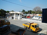
 Municipal hall
 -
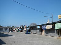
 Town center
 -
 Sudipen Farmers Public Market
 -
 Sudipen Central School
 -
 Sudipen terminal


References
- ^ Municipality of Sudipen | (DILG)
- ^ "2015 Census of Population, Report No. 3 – Population, Land Area, and Population Density" (PDF). Philippine Statistics Authority. Quezon City, Philippines. August 2016. ISSN 0117-1453. Archived (PDF) from the original on 25 May 2021. Retrieved 16 July 2021.
- ^ Census of Population (2020). "Region I (Ilocos Region)". Total Population by Province, City, Municipality and Barangay. Philippine Statistics Authority. Retrieved 8 July 2021.
- ^ "PSA Releases the 2021 City and Municipal Level Poverty Estimates". Philippine Statistics Authority. 2 April 2024. Retrieved 28 April 2024.
- ^ Provincial Government of La Union. "Municipality of Sudipen History". launion.gov.ph. Archived from the original on 30 September 2023. Retrieved 28 December 2024.
- ^ "History of Sudipen". Official Website of Municipality of Sudipen. Retrieved 28 December 2024.
- ^ Philippine Legislature (1917). Revised Administrative Code of the Philippine Islands of 1917 (Act No. 2711) (Digitized from the Presidential Museum and Library Collection, uploaded on February 15, 2016). Bureau of Printing. pp. 22–24. Retrieved 2 February 2017.
- ^ "Executive Order No. 72, s. 1947". Official Gazette (Philippines). Government of the Philippines. 30 July 1947. Retrieved 20 March 2023.
- ^ "𝗗𝗘𝗡𝗥-𝗘𝗠𝗕 𝟭 𝗰𝗼𝗻𝗱𝘂𝗰𝘁𝘀 𝗜𝗻𝗳𝗼𝗿𝗺𝗮𝘁𝗶𝗼𝗻, 𝗘𝗱𝘂𝗰𝗮𝘁𝗶𝗼𝗻 𝗮𝗻𝗱 𝗖𝗼𝗺𝗺𝘂𝗻𝗶𝗰𝗮𝘁𝗶𝗼𝗻 𝗰𝗮𝗺𝗽𝗮𝗶𝗴𝗻 𝗼𝗻 𝗦𝗼𝗹𝗶𝗱 𝗪𝗮𝘀𝘁𝗲 𝗠𝗮𝗻𝗮𝗴𝗲𝗺𝗲𝗻𝘁 𝗮𝘁 𝗠𝘂𝗻𝗶𝗰𝗶𝗽𝗮𝗹𝗶𝘁𝘆 𝗼𝗳 𝗦𝘂𝗱𝗶𝗽𝗲𝗻, 𝗟𝗮 𝗨𝗻𝗶𝗼𝗻 | Environmental Management Bureau Region 1". 2 April 2024. Retrieved 28 December 2024.
- ^ "Province: La Union". PSGC Interactive. Quezon City, Philippines: Philippine Statistics Authority. Retrieved 12 November 2016.
- ^ "Sudipen: Average Temperatures and Rainfall". Meteoblue. Retrieved 26 April 2020.
- ^ Census of Population (2015). "Region I (Ilocos Region)". Total Population by Province, City, Municipality and Barangay. Philippine Statistics Authority. Retrieved 20 June 2016.
- ^ Census of Population and Housing (2010). "Region I (Ilocos Region)" (PDF). Total Population by Province, City, Municipality and Barangay. National Statistics Office. Retrieved 29 June 2016.
- ^ Censuses of Population (1903–2007). "Region I (Ilocos Region)". Table 1. Population Enumerated in Various Censuses by Province/Highly Urbanized City: 1903 to 2007. National Statistics Office.
- ^ "Province of La Union". Municipality Population Data. Local Water Utilities Administration Research Division. Retrieved 17 December 2016.
- ^ "Poverty incidence (PI):". Philippine Statistics Authority. Retrieved 28 December 2020.
- ^ "Estimation of Local Poverty in the Philippines" (PDF). Philippine Statistics Authority. 29 November 2005.
- ^ "2003 City and Municipal Level Poverty Estimates" (PDF). Philippine Statistics Authority. 23 March 2009.
- ^ "City and Municipal Level Poverty Estimates; 2006 and 2009" (PDF). Philippine Statistics Authority. 3 August 2012.
- ^ "2012 Municipal and City Level Poverty Estimates" (PDF). Philippine Statistics Authority. 31 May 2016.
- ^ "Municipal and City Level Small Area Poverty Estimates; 2009, 2012 and 2015". Philippine Statistics Authority. 10 July 2019.
- ^ "PSA Releases the 2018 Municipal and City Level Poverty Estimates". Philippine Statistics Authority. 15 December 2021. Retrieved 22 January 2022.
- ^ "PSA Releases the 2021 City and Municipal Level Poverty Estimates". Philippine Statistics Authority. 2 April 2024. Retrieved 28 April 2024.
- ^ "2019 National and Local Elections" (PDF). Commission on Elections. Retrieved 6 March 2022.
External links
- Philippine Standard Geographic Code
- Philippine Census Information
- Local Governance Performance Management System
Places adjacent to Sudipen | |
|---|---|