Bileća Municipality
History
The first traces of civilization in Bileća date from the Neolithic period, although archaeological sites are insufficiently explored.
During the Middle Ages, Bileća was located on the border with the župa of Vrm and the nearby Vlach necropolis, and was often mentioned as an important crossroad location for caravans on the route from Dubrovnik to Nikšić and Ključ, near Gacko. The town became part of the Bosnian state for the first time in 1373, after the defeat of Nikola Altomanović, but the first mention of the town under its present name was from 25 January 1387, while it was also mentioned as Bilechia in 1438. A document dated from 8 September 1388 mentions that the army of the duke Vlatko Vuković defeated the Turkish army at the Battle of Bileća.
The period from the 13th to the 16th century was marked by the building of a large number of stećci. There were 1724 stećak monoliths recorded in Bileća area during the 1970s, with later research suggesting a higher number. Grebenice-Bunčići site of stećak monuments near Baljci is included in the UNESCO World Heritage list.
Bileća was held by the Turks from 1466, although it was a rebellious area that was difficult to control. During Herzegovina Uprising one of the crucial battles occurred in July 1876 about 6km east of Bileća. Led by Prince Nikola, joint forces of Montenegrin and Herzegovian battalions defeated the Turks in the Battle of Vučji Do, forcing them to withdraw towards Trebinje.
The Congress of Berlin in 1878 included Bileća in the Austro-Hungarian Empire, which brought economic development to the region. The first primary school in Bileća was opened in 1880.
-
 Necropolis of stećak tombstones in Bileća
 -
 Old fortification Drakuljica
 -
 A pit in which Ustaše threw killed Serb civilians from Bileća, a part of the wider Genocide of Serbs
 -
 Yugoslav Partisans from Bileća
 -
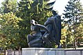 Park of People's Hero
.jpg)


Settlements
Aside from the town of Bileća, the municipality includes the following settlements:
- Baljci
- Bijela Rudina
- Bijeljani
- Bodenik
- Bogdašići
- Brestice
- Čepelica
- Deleuša
- Divin
- Dlakoše
- Dola
- Donja Meka Gruda
- Donji Davidovići
- Đeče
- Fatnica
- Golobrđe
- Gornja Meka Gruda
- Gornji Davidovići
- Granica
- Hodžići
- Kačanj
- Kalac
- Korita
- Krivača
- Krstače
- Kukričje
- Kuti
- Lađevići
- Milavići
- Mirilovići
- Miruše
- Mrežica
- Narat
- Njeganovići
- Oblo Brdo
- Orah
- Orahovice
- Pađeni
- Panik
- Plana
- Podgorje
- Podosoje
- Preraca
- Prijevor
- Prisoje
- Rioca
- Selišta
- Simijova
- Skrobotno
- Šobadine
- Todorići
- Torič
- Trnovica
- Vlahinja
- Vranjska
- Vrbica
- Zasada
- Zaušje
- Zvijerina
- Žudojevići
Demographics
Population
| Population of settlements – Bileća municipality | ||||||||
|---|---|---|---|---|---|---|---|---|
| Settlement | 1948. | 1953. | 1961. | 1971. | 1981. | 1991. | 2013. | |
| Total | 13,531 | 14.026 | 14,125 | 13,444 | 13,199 | 13,284 | 10,807 | |
| 1 | Baljci | 417 | 293 | |||||
| 2 | Bileća | 1,270 | 1,563 | 2,491 | 4,033 | 5,763 | 7,568 | 7,476 |
| 3 | Podosoje | 971 | 1,055 | |||||
Ethnic composition
According to the 1910 census, the absolute majority in the Bileća municipality were Orthodox Christians (82.27%). According to the Kingdom of Yugoslavia 1931 population census, the majority was held by Orthodox Christians at 81.27%.
| Ethnic composition – Bileća town | |||||||
|---|---|---|---|---|---|---|---|
| 2013. | 1991. | 1981. | 1971. | ||||
| Total | 7,616 (100,0%) | 7,568 (100,0%) | 5,763 (100,0%) | 4,033 (100,0%) | |||
| Serbs | 7,500 (98,5%) | 5,619 (74,25%) | 3,882 (67,36%) | 2,810 (69,68%) | |||
| Bosniaks | 7 (0,1%) | 1,290 (17,05%) | 841 (14,59%) | 828 (20,53%) | |||
| Others | 90 (1,2%) | 411 (5,431%) | 26 (0,451%) | 36 (0,893%) | |||
| Yugoslavs | 209 (2,762%) | 651 (11,30%) | 64 (1,587%) | ||||
| Croats | 19 (0,2%) | 39 (0,515%) | 42 (0,729%) | 82 (2,033%) | |||
| Montenegrins | 286 (4,963%) | 190 (4,711%) | |||||
| Macedonians | 23 (0,399%) | 14 (0,347%) | |||||
| Albanians | 7 (0,121%) | 1 (0,025%) | |||||
| Slovenes | 5 (0,087%) | 8 (0,198%) | |||||
| Ethnic composition – Bileća municipality | |||||||
|---|---|---|---|---|---|---|---|
| 2013. | 1991. | 1981. | 1971. | ||||
| Total | 10,807 (100,0%) | 13,284 (100,0%) | 13,199 (100,0%) | 13,444 (100,0%) | |||
| Serbs | 10,646 (98,51%) | 10,628 (80,01%) | 10,190 (77,20%) | 10,880 (80,93%) | |||
| Others | 114 (1,055%) | 448 (3,372%) | 34 (0,258%) | 50 (0,372%) | |||
| Bosniaks | 26 (0,241%) | 1,947 (14,66%) | 1,803 (13,66%) | 2,079 (15,46%) | |||
| Croats | 21 (0,194%) | 39 (0,294%) | 44 (0,333%) | 82 (0,610%) | |||
| Yugoslavs | 222 (1,671%) | 773 (5,857%) | 69 (0,513%) | ||||
| Montenegrins | 317 (2,402%) | 261 (1,941%) | |||||
| Macedonians | 24 (0,182%) | 14 (0,104%) | |||||
| Albanians | 8 (0,061%) | 1 (0,007%) | |||||
| Slovenes | 6 (0,045%) | 8 (0,060%) | |||||
Economy

The following table gives a preview of total number of registered people employed in professional fields per their core activity (as of 2018):
| Professional field | Total |
|---|---|
| Agriculture, forestry and fishing | 2 |
| Mining and quarrying | 1 |
| Manufacturing | 377 |
| Electricity, gas, steam and air conditioning supply | 78 |
| Water supply; sewerage, waste management and remediation activities | 107 |
| Construction | 195 |
| Wholesale and retail trade, repair of motor vehicles and motorcycles | 267 |
| Transportation and storage | 86 |
| Accommodation and food services | 81 |
| Information and communication | 25 |
| Financial and insurance activities | 18 |
| Real estate activities | - |
| Professional, scientific and technical activities | 22 |
| Administrative and support service activities | 4 |
| Public administration and defense; compulsory social security | 225 |
| Education | 193 |
| Human health and social work activities | 80 |
| Arts, entertainment and recreation | 42 |
| Other service activities | 31 |
| Total | 1,834 |
Sports
The local football club FK Hercegovac has spent one season in the country's second tier — First League of the Republika Srpska.
Climate
| Climate data for Bileća (1991–2020) | |||||||||||||
|---|---|---|---|---|---|---|---|---|---|---|---|---|---|
| Month | Jan | Feb | Mar | Apr | May | Jun | Jul | Aug | Sep | Oct | Nov | Dec | Year |
| Mean daily maximum °C (°F) | 8.9 (48.0) |
10.2 (50.4) |
14.3 (57.7) |
16.7 (62.1) |
21.1 (70.0) |
26.7 (80.1) |
28.1 (82.6) |
30.6 (87.1) |
25.6 (78.1) |
17.6 (63.7) |
13.8 (56.8) |
9.1 (48.4) |
18.6 (65.5) |
| Daily mean °C (°F) | 3.8 (38.8) |
4.9 (40.8) |
7.9 (46.2) |
11.4 (52.5) |
16.1 (61.0) |
20.8 (69.4) |
23.2 (73.8) |
23.2 (73.8) |
17.7 (63.9) |
13.3 (55.9) |
8.9 (48.0) |
4.8 (40.6) |
13.0 (55.4) |
| Mean daily minimum °C (°F) | −0.5 (31.1) |
−0.5 (31.1) |
2.8 (37.0) |
5.3 (41.5) |
9.6 (49.3) |
13.2 (55.8) |
15.3 (59.5) |
15.3 (59.5) |
11.8 (53.2) |
7.5 (45.5) |
4.2 (39.6) |
0.2 (32.4) |
7.0 (44.6) |
| Average precipitation mm (inches) | 147.8 (5.82) |
149.8 (5.90) |
133.5 (5.26) |
120.3 (4.74) |
99.8 (3.93) |
76.8 (3.02) |
53.5 (2.11) |
58.1 (2.29) |
125.1 (4.93) |
179.0 (7.05) |
224.2 (8.83) |
198.5 (7.81) |
1,566.3 (61.67) |
| Average precipitation days (≥ 1.0 mm) | 9.8 | 9.9 | 9.5 | 9.7 | 9.5 | 7.6 | 5.1 | 5.2 | 8.0 | 9.4 | 11.1 | 11.2 | 106.2 |
| Source: NOAA | |||||||||||||
Notes
- The Diocese of Zahumlje-Herzegovina and Littoral (official site in Serbian), Serbian Orthodox Church (official site in English) Archived 2011-02-24 at the Wayback Machine
- Hydroelectric power plants on the Trebisnjica River (near Bileća)
- Lake Bileća (Bilećko jezero) is located south of the town.
Notable people
.jpg)

- Safet Isović, singer
- Beba Selimović, singer
- Fadil Hadžić, movie director and writer
- Dušan Vukotić, Oscar for the best animated short in 1961 for Surogat
- Karlo Mijić, painter
- Jevto Dedijer, writer
- Nenad Mišanović, basketball player
- Prokopije Čokorilo, priest
- Ervin Eleskovic, Swedish tennis player
- Tijana Bošković, Serbian volleyball player, World and European champion, silver medalist at the 2016 Summer Olympics
See also
References
- ^ Ciobanu, Octavian (2018). "The emergence of Vlach necropolises with petroglyphs in Western Balkans". Revista de Etnologie şi Culturologie. XXIV: 7.
- ^ Detelić, Mirjana (2007). Epski gradovi. Leksikon [Epic Cities. A lexicon]. Belgrade: Balkanološkog instituta SANU. p. 53. ISBN 9788671790406.
- ^ Ćirković, Sima (2020). Živeti sa istorijom. Belgrade: Helsinški odbor za ljudska prava u Srbiji. p. 218.
- ^ "Историја – Званична презентација општине Билећа". Retrieved 2024-07-15.
- ^ Centre, UNESCO World Heritage. "Stećci Medieval Tombstone Graveyards". UNESCO World Heritage Centre. Retrieved 2024-08-22.
- ^ ipamonte (2016-07-30). "140 godina od bitke na Vučjem dolu". IPA Montenegro. Retrieved 2024-09-12.
- ^ "Cities and Municipalities of Republika Srpska" (PDF). rzs.rs.ba. Republika Srspka Institute of Statistics. 25 December 2019. Retrieved 31 December 2019.
- ^ "Bileca Climate Normals 1991–2020". World Meteorological Organization Climatological Standard Normals (1991–2020). National Oceanic and Atmospheric Administration. Retrieved 4 September 2023.
External links

| International | |
|---|---|
| National | |