Loading
  • 21 Aug, 2019

  • By, Wikipedia

Cho La, Nepal

Cho La is a summit pass located 5,420 metres (17,782 ft) above sea level in the Solukhumbu District in northeastern Nepal. It connects the village of Dzongla (4,830 metres (15,850 ft)) to the east and the village of Thagnak (4,700 metres (15,400 ft)) to the west.

Tourism

The pass is on the Gokyo trail in the Khumbu Everest region. To the west the trail continues to the Gokyo Lakes, crossing the Ngozumpa glacier on the way. To the east the trail joins the Everest Base Camp trek.

The pass can be physically demanding and may require crampons on top of the slippery glacier. The edge of the glacier is unstable. The Cho la Pass is covered in snow for 9 months of the year, with the temperature being below 0 degrees Celcius for a long time.

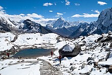
View to the east on descending from Cho La Pass into Chola Valley, 5,200 metres (17,100 ft) a. s. l. Glacial lake, rocks covered with snow, Ama Dablam (6,810 metres (22,343 ft)) and other Himalayas

Elevation

The Everest base camp via Cho la pass trek begins at 2,846 meters (9,337 ft) in Lukla and goes up to 5,545 meters (18,192 ft) at Kala Patthar. Kala Patthar is the highest point of this trek. From the starting point of the trek to the highest point, the altitude gain is 2,699 meters (8,855 ft).

During the trek, you will go above 5,000 meters (16,404 ft) multiple times in these places: Nagarjuna Hill (5,100 m/16,732 ft), Gorak Shep (5,164 m/16,942 ft), Everest Base Camp (5,364 m/17,598 ft), Kala Patthar (5,545 m/18,192 ft), Cho La (5,420 m/17,782 ft), and Gokyo Ri (5,357 m/17,575 ft).

References

  1. ^ Armington, Stan (2001). Trekking in the Nepal Himalaya. Lonely Planet. pp. 480. ISBN 978-1864502312.
  2. ^ Hiking, Adventure Treks. "Chola Pass". Chola Pass.
  3. ^ "Gokyo chola pass trekking - A Perfect Itinerary".