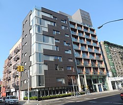
Delancey Street (Manhattan)
Delancey Street is named after James De Lancey Sr., chief justice, lieutenant governor, and acting colonial governor of the Province of New York, whose farm was located in what is now called the Lower East Side. There is also a Delancey Street in Camden Town, London, England, a residential street named after another James Delancey, of Marylebone, who had a number of fields west of the High Street.
Businesses range from delis to check-cashing stores to bars. Delancey Street has long been known for its discount and bargain clothing stores. Famous establishments include the Bowery Ballroom, built in 1929, Ratner's kosher restaurant (now closed), and the Essex Street Market, which was built by Mayor Fiorello La Guardia to avoid pushcart congestion on the neighborhood's narrow streets.
Until the middle 20th century, Delancey Street was a main shopping street in the predominantly Jewish and Irish Lower East Side. Since the late 2000s, the neighborhood around Delancey is more diverse; including African Americans, Puerto Ricans, Dominicans, and Chinese. Gentrification has brought more upscale retail and nightlife establishments.
Transportation
The New York City Subway's F, <F>, J, M, and Z trains serve the Delancey Street/Essex Street station, and the J and Z trains also stop at the Bowery station.
Under New York City Bus, the B39 is Delancey Street’s main bus, running between Allen & Clinton Streets. In addition, the M14D SBS and M21 run in the westbound direction to Columbia Street, where the former terminates, from the FDR Drive and Lewis Street, respectively (eastbound M21 buses cross on the FDR Drive). The M9 and M14A SBS cross on Essex Street, the M15 and M15 SBS on Allen Street, and the M103 on Bowery.
The Williamsburg Bridge Trolley Terminal, beneath Delancey and Essex Streets, was a station and balloon loop for streetcars crossing the Williamsburg Bridge from Brooklyn. The Lowline, an underground public park in which natural light would be directed using fiber optics to create a setting in which trees and grass could be grown indoors, was proposed in 2011.
Because Delancey Street is very wide, and because of its high rate of fatalities, safety measures were erected along its length in the 2000s and 2010s. This includes pedestrian plazas, bans on left turns along the street, and pedestrian countdown signals. A protected bike lane was constructed on Delancey Street from Chrystie Street to the Williamsburg Bridge in November 2018, in advance of the 14th Street Tunnel shutdown. In January 2023, city officials received a $21 million grant from the federal government to add bike lanes, widen sidewalks, and reduce vehicular lanes along Delancey Street.
Kenmare Street

Kenmare Street extends five blocks from the Bowery to Lafayette Street. It is a major thoroughfare for traffic traveling westbound to the Holland Tunnel. The street was founded in 1911, by Tim Sullivan, the son of immigrants Daniel O’Sullivan and Catherine Connelly, who came from Kenmare, County Kerry, Ireland.
References
Notes
- ^ Hayes, David A.; Camden History Society (2020). CAMDEN STREET NAMES and their origins (PDF) (Report).
- ^ "Manhattan Bus Map" (PDF). Metropolitan Transportation Authority. July 2019. Retrieved December 1, 2020.
- ^ Foderaro, Lisa W. (November 21, 2011). "Inspired by High Line, Park Is Envisioned With Sights Set Low". The New York Times. Retrieved November 21, 2011.
- ^ Cohen, Andrew (September 22, 2011). "Plans for Delancey Underground presented to Community Board 3". Bowery Boogie. Archived from the original on September 26, 2011.
- ^ "Delancey Street 2012" (PDF). New York City Department of Transportation. February 8, 2012.
- ^ Robbins, Christopher (November 15, 2018). "The New Delancey Street Bike Lane Has A Potentially Dangerous Flaw". Gothamist. Retrieved February 2, 2023.
- ^ Nessen, Stephen (February 1, 2023). "Delancey Street to get 'road diet' thanks to $21M from feds". Gothamist. Retrieved February 2, 2023.
- ^ "The story of how New York's Kenmare St got its name from famine emigrants". Irish Central. March 10, 2017.
External links
- Delancey Street Storefronts - photographs of buildings and stores along Delancey Street.
- Delancey Street: A New York Songline - a virtual walking tour
- Cuban Pete - Desi and Lucy performing "Cuban Pete"