Church Street and Trinity Place form a single northbound roadway in Lower Manhattan, New York City. Its northern end is at Canal Street and its southern end is at Morris Street, where Trinity Place merges with Greenwich Street. The dividing point is Liberty Street.
Description
Trinity Place branches off Greenwich Street at Morris Street, running uptown to the northeast, passing west of Trinity Church, the Trinity and United States Realty Buildings, and Zuccotti Park. At Liberty Street it becomes Church Street, which forms the eastern boundary of the World Trade Center to Vesey Street. At Franklin Street, a few blocks south of Canal Street, Avenue of the Americas (Sixth Avenue) branches off. Trinity Place, Church Street, and Avenue of the Americas form a continuous northbound through-route from Lower Manhattan to Central Park.
Church Street is named after Trinity Church, a historic Gothic-style parish church on Broadway at Wall Street. Extended in 1784, Church Street was in existence as early as 1761. Part of the street was owned by the church, but was given to the city in 1804. Trinity Place is also a namesake of the church, being named so in 1834, prior to which it was known at various times as "Lumber Street" and "Lombard Street".
Before 1869, the south end of Church Street was at Fulton Street, three blocks north of Trinity Place. Then, over several years, an 80-foot wide connection was cut through the intervening blocks and Trinity Place was widened to 80 feet (24 m) and extended south to Morris Street; Church Street north of Fulton Street was left 40 feet (12 m) wide at the time. The work, plagued by delays and allegedly corruption, was completed by the end of 1872.
In June 1878 an elevated railway line, the IRT Sixth Avenue Line, opened. It ran on Trinity Place and Church Street to Murray Street, where it turned west and then north on West Broadway. It closed in 1938 and was razed the following year.
As part of the construction of the Eighth Avenue subway line, from 1929 to 1932 Church Street was widened between Fulton Street and Franklin Street from 40 feet including 10-foot sidewalks, to 90 feet including 15-foot sidewalks. Only the west property line was moved; the east side of the street was left intact.
Places
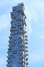
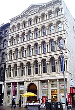
The Church Street Station post office at 90 Church Street serves the 10048 ZIP code as well as the surrounding area, and is listed on the National Register of Historic Places (NRHP), as is the Canal Street Station post office at the north end of Church Street. Just south of the latter is the former Long Distance Building of the American Telephone & Telegraph Company, at 32 Avenue of the Americas, also known as 310–322 Church Street, a New York City designated landmark (NYCL). The Cary Building and St. Peter's Church are both New York City landmarks also listed on the NRHP. Church Street borders the rear of the 1765 St. Paul's Chapel, another NYC landmark on the NRHP as well as a U.S. National Historic Landmark (NHL). Also notable are the residential towers at 30 Park Place and 56 Leonard Street, and the former AT&T Long Lines Building at 33 Thomas Street.
Near Rector Street, Trinity Place passes under the Trinity Place bridge. Designed by LHP Architects and completed in 1989, the bridge is a private elevated walkway which formerly connected the rear side of Trinity Church to its offices and preschool in the Trinity Court Building across Trinity Place. That building has been demolished, and its replacement is currently under construction, with the opening expected in 2020. The bridge has been preserved and will return to use at that time.
Directly north of that site is the American Stock Exchange Building, listed on the NRHP and an NHL. Next to that are the Leadership & Public Service High School and High School of Economics and Finance, both New York City public high schools.
-
-
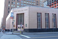 Canal Street Station post office
 -
-
 Rear of St. Paul's Chapel in 1937
 -

-
 Lobby of 32 Avenue of the Americas
.jpg)


Other historic sites on or just off Trinity Place or Church Street:
- Cunard Building on Morris Street, at the foot of Trinity Place, is visible the entire length of Trinity Place and Church Street (NYCL)
- Robert and Anne Dickey House at Edgar Street (NYCL)
- 65 Broadway, between Exchange Alley and Rector Street (NYCL)
- Empire Building at Rector Street (NRHP, NYCL)
- Old New York Evening Post Building, 20 Vesey Street, between Church Street and Broadway (NRHP, NYCL)
- New York County Lawyers' Association Building, 14 Vesey Street, between Church Street and Broadway (NRHP, NYCL)
- 23 and 25 Park Place Buildings, between Church Street and Broadway (NYCL)
- Kitchen, Montross & Wilcox Store, 85 Leonard Street, between Church Street and Broadway (NRHP, NYCL)
In addition, Church Street runs through Tribeca South and Tribeca East Historic Districts (NYCL).
Transportation
The IND Eighth Avenue Line (A, C, and E trains) of the New York City Subway runs below Church Street north of Fulton Street to Sixth Avenue. A portion of the BMT Broadway Line (N, R, and W trains) runs under Church Street and Trinity Place from Greenwich Street to Fulton Street. Its Cortlandt Street station, damaged in the September 11 attacks, is adjacent to the World Trade Center.
The uptown M55 bus runs along Trinity Place/Church Street from Morris Street to Franklin Street, where it continues north on Sixth Avenue (downtown buses use Broadway). Additional service is provided by the downtown M9 running north from Barclay to Murray Streets (uptown buses cross east on Warren Street).
See also
References
Notes
- ^ "MTA Neighborhood Maps: Lower Manhattan" (PDF). Metropolitan Transportation Authority of New York State. September 2018. Archived (PDF) from the original on December 6, 2019. Retrieved December 6, 2019.
- ^ Moscow, Henry (1978). The Street Book: An Encyclopedia of Manhattan's Street Names and Their Origins. New York: Hagstrom Company. ISBN 978-0-8232-1275-0.
- ^ Perris, William. Maps of the City of New-York. Third Edition. Volume 1. Title page and volume key (New York: Perris & Browne, 1857)
- ^ See:
- Insurance Maps of the City of New York Surveyed and Published by Sanborn–Perris Map Co., Limited. Volume 1. (New York: 1894). Volume key and Plate 7.
- "The Church Street Extension" (PDF). The New York Times. May 6, 1869.
- "Church Street Extension" (PDF). The New York Times. August 13, 1870.
- "Cholera Seeds" (PDF). The New York Times. August 19, 1871.
- "New York and Suburban News: New York" (PDF). The New York Times. December 15, 1872. paragraph 5.
- ^ See:
- Jackson, Kenneth T., ed. (1995). The Encyclopedia of New York City. New Haven: Yale University Press. ISBN 0300055366., "Elevated railways", paragraphs 2 and 7.
- G. W. Bromley & Co. (1879). Plate 1 (Map). Atlas of the Entire City of New York. Complete in One Volume. New York: Geo. W. Bromley & E. Robinson.
- "Days of Yore Recalled as 'L' Line Goes". Rochester Democrat and Chronicle. December 5, 1938. p. 9. Retrieved June 30, 2019 – via Newspapers.com
 .
.
- ^ "$9,631,760 Awarded on Church Street". The New York Times. January 6, 1929. "Transit Board Land Ceded To Boroughs". The New York Times. January 28, 1932.
- ^ "National Register Information System". National Register of Historic Places. National Park Service. November 2, 2013.
- ^ "Long Distance Building of the American Telephone & Telegraph Company" (PDF). New York City Landmarks Preservation Commission. October 1, 1991. Retrieved December 6, 2019.
- ^ See:
- "Cary Building" (PDF). New York City Landmarks Preservation Commission. August 24, 1982. Retrieved December 6, 2019.
- "St. Peter's Church" (PDF). New York City Landmarks Preservation Commission. December 21, 1965. Retrieved December 6, 2019.
- ^ "Saint Paul's Chapel and Graveyard" (PDF). New York City Landmarks Preservation Commission. August 16, 1966. Retrieved December 6, 2019.
- ^ "St. Paul's Chapel". National Historic Landmark summary listing. National Park Service. September 11, 2007. Archived from the original on April 13, 2014.
- ^ "Trinity Church Bridge". LHP Architects. Archived from the original on December 5, 2019. Retrieved December 5, 2019.
- ^ Louie, Elaine (April 27, 1989). "Currents: A Footbridge From Another Era". The New York Times. Section C, p. 3.
{{cite web}}: CS1 maint: location (link) - ^ Dunlap, David W. (March 10, 2017). "A Bridge to Nowhere, 19 Feet 8 Inches Over Lower Manhattan". The New York Times. ISSN 0362-4331. Retrieved February 23, 2020.
- ^ "Trinity Commons". Trinity Church Wall Street. Archived from the original on October 26, 2019. Retrieved December 4, 2019.
- Young, Michael (October 22, 2019). "Work At 74 Trinity Place Nears Completion In The Financial District". New York Yimby. Retrieved December 5, 2019.
- (Image captured August 2013) "Church Street and Trinity Place" (Map). Google Maps. Retrieved December 4, 2019.
- (Image captured August 2016) "Church Street and Trinity Place" (Map). Google Maps. Retrieved December 4, 2019.
- (Image captured June 2019) "Church Street and Trinity Place" (Map). Google Maps. Retrieved December 4, 2019.
- ^ Interactive map: "Discover New York City Landmarks". New York City Landmarks Preservation Commission. Retrieved December 21, 2019 – via ArcGIS.
- ^ Breiner, David M. (September 19, 1995). "Cunard Building" (PDF). New York City Landmarks Preservation Commission.
- ^ Shockley, Jay (June 28, 2005). "Robert and Anne Dickey House" (PDF). New York City Landmarks Preservation Commission. Retrieved February 16, 2020.
- ^ Shockley, Jay (December 12, 1995). "American Express Company Building" (PDF). New York City Landmarks Preservation Commission. Retrieved February 16, 2020.
- ^ Shockley, Jay (June 25, 1996). "Empire Building" (PDF). New York City Landmarks Preservation Commission. Retrieved February 16, 2020.
- ^ "Historic Structures Report: Empire Building" (PDF). National Register of Historic Places, National Park Service. January 13, 1983. Retrieved February 16, 2020.
- ^ "New York Evening Post Building" (PDF). New York City Landmarks Preservation Commission. November 23, 1965. Retrieved February 16, 2020.
- ^ "Historic Structures Report: New York Evening Post Building" (PDF). National Register of Historic Places, National Park Service. August 16, 1977. Retrieved February 2, 2020.
- ^ "New York County Lawyers' Association Building" (PDF). New York City Landmarks Preservation Commission. November 23, 1965. Retrieved February 16, 2020.
- ^ "Historic Structures Report: Old New York County Lawyers' Association Building" (PDF). National Register of Historic Places, National Park Service. September 30, 1982. Retrieved February 2, 2020.
- ^ Percival, Marianne (March 13, 2007). "23 Park Place Building" (PDF). New York City Landmarks Preservation Commission.
- ^ Percival, Marianne (March 13, 2007). "25 Park Place Building" (PDF). New York City Landmarks Preservation Commission.
- ^ "Kitchen, Montross & Wilcox Store" (PDF). New York City Landmarks Preservation Commission. November 26, 1974. Retrieved February 16, 2020.
- ^ "Historic Structures Report: 85 Leonard Street" (PDF). National Register of Historic Places, National Park Service. April 23, 1980. Retrieved February 2, 2020.
- ^ Harris, Gale; Urbinelli, Elisa; McHugh, Kevin (December 8, 1992). "Tribeca South Historic District Designation Report" (PDF). New York City Landmarks Preservation Commission.
- ^ Breiner, David M.; Pickart, Margaret M.M. (December 8, 1992). "Tribeca East Historic District Designation Report" (PDF). New York City Landmarks Preservation Commission.
External links
KML is not from Wikidata
 Media related to Church Street (Manhattan) at Wikimedia Commons
- Media related to Trinity Place (Manhattan) at Wikimedia Commons