Füzesabony District
Geography
Borders with Eger District to the north, Mezőkövesd District (Borsod-Abaúj-Zemplén County) and Tiszafüred District (Jász-Nagykun-Szolnok County) to the east, Heves District to the southwest, Gyöngyös District to the west. The number of the inhabited places in Füzesabony District is 16
Füzesabony District is located at the geographic coordinates of 47.7495339 latitude and 20.4150668 longitude. This district is located in the time zone Central European Summer Time.
Municipalities
The district has 1 town, 1 large village and 14 villages.
(ordered by population, as of 1 January 2012)
- Aldebrő (649)
- Besenyőtelek (2,569)
- Dormánd (1,040)
- Egerfarmos (675)
- Füzesabony (7,781) – district seat
- Kál (3,501)
- Kápolna (1,575)
- Kompolt (2,098)
- Mezőszemere (1,232)
- Mezőtárkány (1,575)
- Nagyút (660)
- Poroszló (2,715)
- Sarud (1,126)
- Szihalom (1,938)
- Tófalu (526)
- Újlőrincfalva (250)
The bolded municipality is city, italics municipality is large village.
Demographics
Religion in Füzesabony District (2011 census)
In 2011, it had a population of 30,416 and the population density was 53/km.
| Year | County population | Change |
|---|---|---|
| 2011 | 30,416 | n/a |
Ethnicity
Besides the Hungarian majority, the main minorities are the Roma (approx. 3,000), German (250) and Romanian (100).
Total population (2011 census): 30,416
Ethnic groups (2011 census): Identified themselves: 29,126 persons:
- Hungarians: 25,815 (88.63%)
- Gypsies: 2,775 (9.53%)
- Others and indefinable: 536 (1.84%)
Approx. 1,500 persons in Füzesabony District did not declare their ethnic group at the 2011 census.
Religion
Religious adherence in the county according to 2011 census:
- Catholic – 15,809 (Roman Catholic – 15,694; Greek Catholic – 113);
- Reformed – 1,539;
- Evangelical – 45;
- other religions – 611;
- Non-religious – 3,711;
- Atheism – 185;
- Undeclared – 8,516.
Gallery
-
 Füzesabony, Pusztaszikszó Chapel
 -
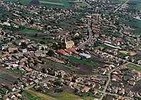 Aerial view of Besenyőtelek
 -
 Lake Tisza EcoCentrum in Poroszló
 -
 St. Peter and Paul Church in Kál


See also
References
- ^ "Füzesabony on the map of Hungary, location on the map, exact time". ng.maptons.com. Retrieved 2024-10-10.
- ^ A KSH 2012. évi helységnévkönyve
- ^ népesség.com, "Füzesabonyi járás népessége"
- ^ 4.1.6.1 A népesség nemzetiség szerint, 2011, (in Hungarian) [1]
- ^ 4.1.7.1 A népesség vallás, felekezet szerint, 2011, (in Hungarian) [2]
External links
| Town (1) |
| |
|---|---|---|
| Large village (1) | ||
| Villages (14) | ||
47°43′00″N 20°28′00″E / 47.7167°N 20.4667°E
This Heves county location article is a stub. You can help Wikipedia by expanding it. |