File:Greensboro-Winston-Salem-High Point CSA.png
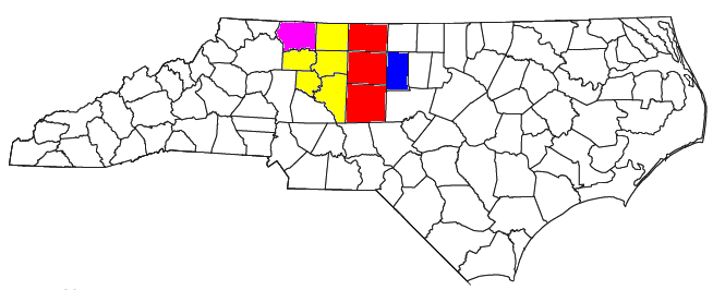
Locator map of the Greensboro-Winston-Salem-High Point Combined Statistical Area in the northern part of the U.S. state of North Carolina. The four components of the CSA are colored separately:
Date
Source
Author
User:Nyttend, Yassie
Permission
(Reusing this file)
- Greensboro-High Point Metropolitan Statistical Area: red
- Winston-Salem Metropolitan Statistical Area: yellow
- Burlington Micropolitan Statistical Area: blue
- Mount Airy Micropolitan Statistical Area: purple
- North Wilkesboro Micropolitan Statistical Area: green
Modified from this United States Census Bureau file, based on the following Census definitions lists:
- OMB BULLETIN NO. 13-01: Revised Delineations of Metropolitan Statistical Areas, Micropolitan Statistical Areas, and Combined Statistical Areas, and Guidance on Uses ofthe Delineations ofThese Areas. Office of Management and Budget. February 28, 2013.
(Reusing this file)
US Government work is public domain, and our work is
| I, the copyright holder of this work, release this work into the public domain. This applies worldwide. In some countries this may not be legally possible; if so: I grant anyone the right to use this work for any purpose, without any conditions, unless such conditions are required by law. |