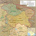
File:Kashmir Region 2004.jpg


.jpg)
-
 version for situation as end of 2019
 -
 Derivative works of this file: Tarbela Dam map.png

Click on a date/time to view the file as it appeared at that time.
| Date/Time | Thumbnail | Dimensions | User | Comment | |
|---|---|---|---|---|---|
| current | 21:45, 6 June 2010 |  | 1,579 × 1,567 (1.71 MB) | Ras67 | slightly rotated and cropped |
| 18:46, 7 March 2006 |  | 1,616 × 1,623 (789 KB) | Jungpionier | Kashmir Region 2004 Source URL: [http://www.lib.utexas.edu/maps/middle_east_and_asia/kashmir_region_2004.jpg]. {{PD-USGov-CIA}} |
The following 31 pages use this file:
The following other wikis use this file:
View more global usage of this file.