Kargilik County
History
In 1975, future Chinese Communist Party Deputy Committee Secretary of the Xinjiang Uyghur Autonomous Region Zhu Hailun was sent to Kargilik County in the Down to the Countryside Movement.
Geography
The northern part of the county is in the Taklamakan Desert and the southern part of the county is in the Kunlun Mountains. Mazar Pass is located in the southern part of the county.
Climate
| Climate data for Kargilik, elevation 1,360 m (4,460 ft), (1991–2020 normals, extremes 1981–2010) | |||||||||||||
|---|---|---|---|---|---|---|---|---|---|---|---|---|---|
| Month | Jan | Feb | Mar | Apr | May | Jun | Jul | Aug | Sep | Oct | Nov | Dec | Year |
| Record high °C (°F) | 20.2 (68.4) |
20.3 (68.5) |
31.5 (88.7) |
34.0 (93.2) |
36.8 (98.2) |
40.2 (104.4) |
38.2 (100.8) |
38.1 (100.6) |
33.3 (91.9) |
29.2 (84.6) |
24.6 (76.3) |
19.0 (66.2) |
40.2 (104.4) |
| Mean daily maximum °C (°F) | 1.1 (34.0) |
6.7 (44.1) |
15.8 (60.4) |
23.3 (73.9) |
27.3 (81.1) |
30.8 (87.4) |
32.3 (90.1) |
30.7 (87.3) |
26.6 (79.9) |
20.5 (68.9) |
12.1 (53.8) |
3.3 (37.9) |
19.2 (66.6) |
| Daily mean °C (°F) | −4.7 (23.5) |
0.9 (33.6) |
9.4 (48.9) |
16.5 (61.7) |
20.4 (68.7) |
23.9 (75.0) |
25.5 (77.9) |
24.2 (75.6) |
19.9 (67.8) |
13.1 (55.6) |
4.9 (40.8) |
−2.5 (27.5) |
12.6 (54.7) |
| Mean daily minimum °C (°F) | −9.5 (14.9) |
−3.9 (25.0) |
3.7 (38.7) |
10.5 (50.9) |
14.3 (57.7) |
17.9 (64.2) |
19.7 (67.5) |
18.7 (65.7) |
14.1 (57.4) |
6.8 (44.2) |
−0.7 (30.7) |
−7.0 (19.4) |
7.1 (44.7) |
| Record low °C (°F) | −20.8 (−5.4) |
−20.8 (−5.4) |
−7.1 (19.2) |
0.0 (32.0) |
4.9 (40.8) |
9.3 (48.7) |
11.7 (53.1) |
10.0 (50.0) |
3.6 (38.5) |
−2.2 (28.0) |
−12.2 (10.0) |
−21.9 (−7.4) |
−21.9 (−7.4) |
| Average precipitation mm (inches) | 2.8 (0.11) |
2.8 (0.11) |
5.4 (0.21) |
4.7 (0.19) |
17.0 (0.67) |
11.7 (0.46) |
11.3 (0.44) |
11.1 (0.44) |
9.0 (0.35) |
1.0 (0.04) |
1.8 (0.07) |
1.5 (0.06) |
80.1 (3.15) |
| Average precipitation days (≥ 0.1 mm) | 2.5 | 2.1 | 1.4 | 1.7 | 3.4 | 4.5 | 4.0 | 3.6 | 2.7 | 0.5 | 0.6 | 1.9 | 28.9 |
| Average snowy days | 5.7 | 3.4 | 0.6 | 0.1 | 0 | 0 | 0 | 0 | 0 | 0 | 0.6 | 4.5 | 14.9 |
| Average relative humidity (%) | 58 | 50 | 38 | 33 | 38 | 40 | 44 | 48 | 49 | 45 | 48 | 59 | 46 |
| Mean monthly sunshine hours | 180.8 | 177.2 | 216.1 | 229.3 | 272.2 | 295.8 | 295.6 | 262.2 | 251.0 | 261.0 | 218.3 | 179.7 | 2,839.2 |
| Percent possible sunshine | 59 | 57 | 57 | 57 | 61 | 67 | 67 | 63 | 69 | 77 | 73 | 61 | 64 |
| Source: China Meteorological Administration | |||||||||||||
Administrative divisions
Kargilik County contains 6 towns and 15 townships.
| Name | Simplified Chinese | Hanyu Pinyin | Uyghur (UEY) | Uyghur Latin (ULY) | Administrative division code | Notes | |
|---|---|---|---|---|---|---|---|
| Towns | |||||||
| Kargilik Town | 喀格勒克镇 | Kāgélèkè Zhèn | پوسكام بازىرى | qaghiliq baziri | 653126100 | ||
| Charbagh Town | 恰尔巴格镇 | Qià'ěrbāgé Zhèn | چارباغ بازىرى | charbagh baziri | 653126101 | ||
| Ushsharbash Town | 乌夏巴什镇 | Wūxiàbāshí Zhèn | ئۇششارباش بازىرى | Ushsharbash baziri | 653126102 | ||
| Aqash Town | 阿克塔什镇 | Ākètǎshí Zhèn | ئاقتاش بازىرى | Aqtash baziri | 653126103 | ||
| Jinguo Town | 金果镇 | Jīnguǒ Zhèn | جىنگو بازىرى | jingo baziri | 653126104 | Formerly Chasa Meschit Township (چاسا مەسچىت يېزىسى / 恰萨美其特乡) | |
| Yitimliqum Town | 依提木孔镇 | Kāgélèkè Zhèn | يىتىملىقۇم بازىرى | yitimliqum baziri | 653126105 | Formerly Yitimliqum Township (يىتىملىقۇم يېزىسى / 依提木孔乡) | |
| Townships | |||||||
| Loq Township | 洛克乡 | Luòkè Xiāng | لوق يېزىسى | loq yëzisi | 653126200 | ||
| Besheriq Township | 伯西热克乡 | Bóxīrèkè Xiāng | بەشئېرىق يېزىسى | besh'ëriq yëzisi | 653126201 | ||
| Tetir Township | 铁提乡 | Tiětí Xiāng | تېتىر يېزىسى | tëtir yëzisi | 653126202 | ||
| Tögichi Township | 吐古其乡 | Tǔgǔqí Xiāng | تۆگىچى يېزىسى | tögichi yëzisi | 653126204 | ||
| Janggilieski Township | 江格勒斯乡 | Jiānggélèsī Xiāng | جاڭگىلىئەسكى يېزىسى | janggili'eski yëzisi | 653126205 | ||
| Jayterak Township | 加依提勒克乡 | Jiāyītílèkè Xiāng | جايتېرەك يېزىسى | jaytërek yëzisi | 653126206 | ||
| Barin Township | 巴仁乡 | Bārén Xiāng | بارىن يېزىسى | barin yëzisi | 653126207 | ||
| Ghojaeriq Township | 乌吉热克乡 | Wūjírèkè Xiāng | غوجائېرىق يېزىسى | ghoja'ëriq yëzisi | 653126208 | ||
| Shaxap Township | 夏合甫乡 | Wūjírèkè Xiāng | شاخاپ يېزىسى | shaxap yëzisi | 653126209 | ||
| Yilkiqi Township | 依力克其乡 | Yīlìkèqí Xiāng | يىلقىچى يېزىسى | yilqichi yëzisi | 653126210 | ||
| Zunglang Township | 宗朗乡 | Zōnglǎng Xiāng | زۇڭلاڭ يېزىسى | zunglang yëzisi | 653126212 | ||
| Kokyar Township | 柯克亚乡 | Kēkèyà Xiāng | كۆكيار يېزىسى | kökyar yëzisi | 653126213 | ||
| Shixshu Township | 西合休乡 | Xīhéxiū Xiāng | شىخشۇ يېزىسى | shixshu yëzisi | 653126214 | ||
| Chipan Township | 棋盘乡 | Qípán Xiāng | چىپان يېزىسى | chipan yëzisi | 653126215 | ||
| Saybagh Township | 萨依巴格乡 | Sàyībāgé Xiāng | سايباغ يېزىسى | saybagh yëzisi | 653126216 | ||
Economy
Kargilik County's economy is based on agriculture and animal husbandry. Agricultural products include wheat, corn and cotton, as well as pomegranates, yellow pears, walnuts, and dried apricots. Industries include construction, machinery, electronics, and food processing. The county is known for the 'Kargilik Banximao Sheep' (叶城半细毛羊).
Demographics
| Year | Pop. | ±% p.a. |
|---|---|---|
| 2000 | 370,229 | — |
| 2010 | 454,328 | +2.07% |
In 1997, Uyghurs made up 93% of the population of the county and Han Chinese made up 6% of the population.
As of 2015, 490,417 of the 519,962 residents of the county were Uyghur, 23,408 were Han Chinese and 6,137 were from other ethnic groups.
As of 2018, Uyghurs made up 91% of the population of the county.
As of 1999, 90.78% of the population of Kargilik (Yecheng) County was Uyghur and 8.18% of the population was Han Chinese.
Transportation
Historical maps
Historical English-language maps including Kargilik:
-
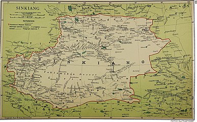 Map including Kargilik (labeled as Kargalik) (1917)
 -
 Map including Kargilik (labeled as YEH-CH'ENG (KARGHALIK)) and surrounding region from the International Map of the World (AMS, 1966)
 -
 Map including Kargilik (labeled as Yeh-ch'eng (Karghalik)) (ACIC, 1969)
 -
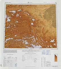
![From the Operational Navigation Chart; map including Kargilik (labeled as YECHENG (YEH-CH'ENG)) (DMA, 1980)[b]](//upload.wikimedia.org/wikipedia/commons/thumb/f/fb/Operational_Navigation_Chart_G-7%2C_6th_edition.jpg/331px-Operational_Navigation_Chart_G-7%2C_6th_edition.jpg) From the Operational Navigation Chart; map including Kargilik (labeled as YECHENG (YEH-CH'ENG)) (DMA, 1980)
From the Operational Navigation Chart; map including Kargilik (labeled as YECHENG (YEH-CH'ENG)) (DMA, 1980) -
![Map including Kargilik (labeled as YECHENG (YEH-CH'ENG)) (DMA, 1984)[c]](//upload.wikimedia.org/wikipedia/commons/thumb/a/a1/Txu-pclmaps-oclc-22834566_g-7a.jpg/335px-Txu-pclmaps-oclc-22834566_g-7a.jpg) Map including Kargilik (labeled as YECHENG (YEH-CH'ENG)) (DMA, 1984)
Map including Kargilik (labeled as YECHENG (YEH-CH'ENG)) (DMA, 1984) -
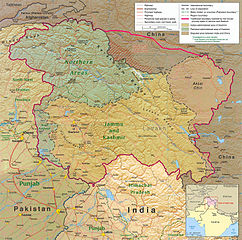 The southern part of Kargilik County includes territory ceded to China by Pakistan but claimed by India
_p61_PLATE19._SINKIANG_(14597194848).jpg)


![From the Operational Navigation Chart; map including Kargilik (labeled as YECHENG (YEH-CH'ENG)) (DMA, 1980)[b]](/key/File:Operational_Navigation_Chart_G-7,_6th_edition.jpg)
![Map including Kargilik (labeled as YECHENG (YEH-CH'ENG)) (DMA, 1984)[c]](/key/File:Txu-pclmaps-oclc-22834566_g-7a.jpg)

See also
Notes
- ^ Locals in Xinjiang frequently observe UTC+6 (Xinjiang Time), 2 hours behind Beijing.
- ^ From map: "The representation of international boundaries is not necessarily authoritative."
- ^ From map: "The representation of international boundaries is not necessarily authoritative"
References
- ^ Xinjiang: Prefectures, Cities, Districts and Counties
- ^ 叶城概况. 叶城县人民政府网 (in Simplified Chinese). Archived from the original on 21 January 2019. Retrieved 31 January 2020 – via Internet Archive.
全县国土总面积3.1万平方公里,耕地面积113万亩。县辖20个乡镇、5个农林牧场、1个管理区,总人口50余万人,聚居着维吾尔、汉、哈萨克、回、柯尔克孜、蒙古、塔吉克、俄罗斯、乌孜别克等13个主要民族,其中维吾尔族占93%、汉族占6%、其它少数民族占1%。与巴基斯坦、印控克什米尔地区接壤,边境线长达80多公里。
- ^ 1997年叶城县行政区划. XZQH.org (in Simplified Chinese). 19 November 2010. Retrieved 31 January 2020.
有维吾尔、汉、柯尔克孜、乌孜别克、塔吉克、回等民族,其中维吾尔族占93%,汉族占6%,
- ^ "Foreign Ministry Spokesperson Hua Chunying's Regular Press Conference on June 23, 2014". Ministry of Foreign Affairs of the People's Republic of China. 23 June 2014. Retrieved 31 January 2020.
The Xinhua news agency has released information on the terrorist violent attack happened on June 21 in Kargilik county of Xinjiang, to which you may refer.
- ^ Li Fangfang (23 February 2017). "Opportunity in Diversity". Beijing Review. Retrieved 24 March 2020.
Four years ago, Nurahmet Memet was a farmer in northwest China's Xinjiang Uygur Autonomous Region. Today, he no longer leads a hardscrabble life in southern Kargilik County, next to the Taklamakan Desert, and instead has become a successful company manager and businessman after relocating to central Xinjiang.
- ^ Chavkin, Sasha (2019-11-24). "China Cables. Xinjiang's Architect of Mass Detention Zhu Hailun". International Consortium of Investigative Journalists. Retrieved 2019-11-24.
- ^ 中国气象数据网 – WeatherBk Data (in Simplified Chinese). China Meteorological Administration. Retrieved 10 October 2023.
- ^ 中国气象数据网 (in Simplified Chinese). China Meteorological Administration. Retrieved 10 October 2023.
- ^ 2018年统计用区划代码和城乡划分代码:叶城县 (in Simplified Chinese). National Bureau of Statistics of the People's Republic of China. 2018. Retrieved 27 January 2020.
统计用区划代码 名称 653126100000 喀格勒克镇 653126101000 恰尔巴格镇 653126102000 乌夏巴什镇 653126200000 洛克乡 653126201000 伯西热克乡 653126202000 铁提乡 653126203000 恰萨美其特乡 653126204000 吐古其乡 653126205000 江格勒斯乡 653126206000 加依提勒克乡 653126207000 巴仁乡 653126208000 乌吉热克乡 653126209000 夏合甫乡 653126210000 依力克其乡 653126211000 依提木孔乡 653126212000 宗朗乡 653126213000 柯克亚乡 653126214000 西合休乡 653126215000 棋盘乡 653126216000 萨依巴格乡 653126402000 阿克塔什农场 653126403000 良种场 653126404000 园艺场 653126405000 林场 653126408000 恰其库木管理区 653126409000 叶城工业园区 653126500000 兵团叶城牧场
- ^ 叶城县历史沿革. XZQH.org (in Simplified Chinese). 14 November 2010. Retrieved 31 January 2020.
2000年第五次人口普查,叶城县常住总人口370229人,{...}2010年第六次人口普查,叶城县常住总人口454328人,其中:喀格勒克镇75730人,恰尔巴格镇21189人,乌夏巴什镇21582人,洛克乡20612人,伯西热克乡33486人,铁提乡15656人,恰萨美其特乡17515人,吐古其乡20476人,江格勒斯乡18844人,加依提勒克乡23374人,巴仁乡10139人,乌吉热克乡20763人,夏合甫乡18734人,依力克其乡14869人,依提木孔乡36052人,宗朗乡6247人,柯克亚乡19451人,西合休乡5535人,棋盘乡16224人,萨依巴格乡22525人,公安农场425人,阿克塔什农场545人,良种场1861人,园艺场1378人,林场1148人,普萨牧场1076人,种畜场348人,恰其库木管理区7562人,兵团叶城牧场982人。
- ^ huaxia, ed. (17 September 2020). "Full Text: Employment and Labor Rights in Xinjiang". Xinhua News Agency. Retrieved 20 September 2020.
Likewise, another villager named Mamtimin Turamat from Ushsharbash Town, Yecheng (Qaghilik) County, Kashgar Prefecture
- ^ Jayterak (Approved - N) at GEOnet Names Server, United States National Geospatial-Intelligence Agency
- ^ 夏征农; 陈至立, eds. (September 2009). 辞海:第六版彩图本 [Cihai (Sixth Edition in Color)] (in Chinese). 上海. Shanghai: 上海辞书出版社. Shanghai Lexicographical Publishing House. p. 2678. ISBN 9787532628599.
经济以农、牧业为主,农产小麦、玉米和棉花,并产石榴、香梨、核桃、杏干。工业有建材、机械、电力、食品加工等。畜产以"叶城半细毛羊"著名。
- ^ 3-7 各地、州、市、县(市)分民族人口数 (in Chinese (China)). Xinjiang Uyghur Autonomous Region Bureau of Statistics. Archived from the original on 2017-10-11. Retrieved 2017-09-03.
- ^ 叶城概况 [Kargilik Overview]. 叶城县人民政府网 (in Simplified Chinese). 15 August 2018. Archived from the original on 20 December 2018. Retrieved 23 March 2020.
总人口55万余人,其中维吾尔族占91%。
- ^ Morris Rossabi, ed. (2004). Governing China's Multiethnic Frontiers (PDF). University of Washington Press. p. 179. ISBN 0-295-98390-6.