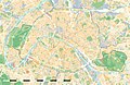
File:Paris Department Land Cover Location Map.svg
Own work
Sources of data:
Creator
Permission
(Reusing this file)
Geotemporal data
Date depicted
Map location
Paris 48°51′24″N 2°21′03″E / 48.8567°N 2.3508°E
Spatial reference system
WGS84 datum
Scale
1:124,000 (precision: 31 m)
Heading

Bounding box
Georeferencing
If inappropriate please set warp_status = skip to hide.
Other versions
Sources of data:
- Modes d'Occupation du Sol (MOS) from the Institut d'Aménagement et d'urbanisme de l'Île-de-France (Open Database licence), 2012-01 data;
- Boundaries from the Institut d'Aménagement et d'urbanisme de l'Île-de-France (Open Database licence), 2011-01 data.
(Reusing this file)
| Attribution and Share-Alike required |
|---|
| Any use of this map can be made as long as you credit me (Eric Gaba – Wikimedia Commons user: Sting) as the author and distribute the copies and derivative works under the same license(s) that the one(s) stated below. A message with a reply address would also be greatly appreciated. |

| 48°54′45″N 2°12′45″E / 48.9125°N 2.2125°E | 48°54′45″N 2°28′30″E / 48.9125°N 2.475°E | |
 |
||
| 48°48′00″N 2°12′45″E / 48.800°N 2.2125°E | 48°48′00″N 2°28′30″E / 48.800°N 2.475°E |
-
 Equivalent administrative map
 -
 Equivalent physical map
 -
 Same map but raster


Licensing
Eric Gaba, Wikimedia Commons user Sting, the copyright holder of this work, hereby publishes it under the following license:
This file is licensed under the Creative Commons Attribution-Share Alike 3.0 Unported license.
Attribution: Eric Gaba, Wikimedia Commons user Sting
- You are free:
- to share – to copy, distribute and transmit the work
- to remix – to adapt the work
- Under the following conditions:
- attribution – You must give appropriate credit, provide a link to the license, and indicate if changes were made. You may do so in any reasonable manner, but not in any way that suggests the licensor endorses you or your use.
- share alike – If you remix, transform, or build upon the material, you must distribute your contributions under the same or compatible license as the original.
