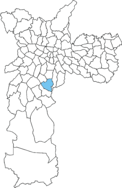
Jabaquara (district Of São Paulo)
23°38′11″S 46°38′45″W / 23.6364°S 46.6459°W
Jabaquara | |
|---|---|
 District of the city of São Paulo | |
| Country | |
| State | |
| Municipality | |
| Subprefecture | Jabaquara |
| Area | |
• Total | 14.10 km (5.44 sq mi) |
| Population (2007) | |
• Total | 223,780 |
| • Density | 15,871/km (41,110/sq mi) |
| Website | Subprefecture of Jabaquara |
Jabaquara is one of 96 districts in the city of São Paulo, Brazil. The name Jabaquara comes from tupi, îababa (escape) and kûara (den). Most probably due to several quilombos that existed in the area.
Avenida Engenheiro Armando de Arruda Pereira is the main road that runs through the district. This road is part of the São Mateus–Jabaquara Metropolitan Corridor, which connects with the ABC Paulista region. The district is also home to a section of the Rodovia dos Imigrantes located in the capital of São Paulo.
See also
References
- ^ "Dados Demográficos dos Distritos pertencentes as Subprefeituras". prefeitura.sp.gov.br (in Portuguese). City of São Paulo. Archived from the original on 4 February 2015. Retrieved 28 December 2014.
- ^ NAVARRO, E. A. Método moderno de tupi antigo: a língua do Brasil dos primeiros séculos. Terceira edição. São Paulo: Global, 2005. p. 168
- ^ "Jabaquara - Guia do bairro Jabaquara -SP Aqui você Encontra !". www.encontrajabaquara.com.br (in Brazilian Portuguese). Retrieved 2025-01-08.
