LL Postcode Area
The LL postcode area, also known as the Llandudno postcode area, is a group of 67 postcode districts, within 62 post towns. These cover the majority of north and north-west Wales, plus a very small part of the English county of Shropshire. The districts start at LL11 so as to avoid confusion with Liverpool postcodes (LL1–9 would resemble L11–19).
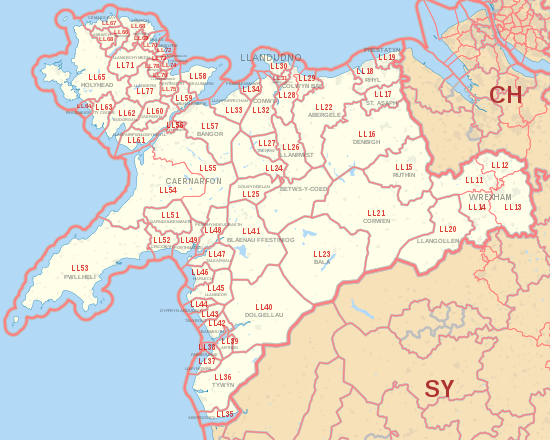
LL postcode area map, showing postcode districts in red and post towns in grey text, with links to nearby CH and SY postcode areas. 
Detailed map of postcode districts and post towns in eastern Anglesey
Post towns
The post towns are:
- Aberdovey
- Abergele
- Amlwch
- Arthog
- Bala
- Bangor
- Barmouth
- Beaumaris
- Benllech
- Betws-y-Coed
- Blaenau Ffestiniog
- Bodorgan
- Brynteg
- Caernarfon
- Cemaes Bay
- Colwyn Bay
- Conwy
- Corwen
- Criccieth
- Denbigh
- Dolgellau
- Dolwyddelan
- Dulas
- Dyffryn Ardudwy
- Fairbourne
- Gaerwen
- Garndolbenmaen
- Harlech
- Holyhead
- Llanbedr
- Llanbedrgoch
- Llandudno
- Llandudno Junction
- Llanerchymedd
- Llanfairfechan
- Llanfairpwllgwyngyll
- Llangefni
- Llangollen
- Llanrwst
- Llwyngwril
- Marianglas
- Menai Bridge
- Moelfre
- Penmaenmawr
- Penrhyndeudraeth
- Pentraeth
- Penysarn
- Porthmadog
- Prestatyn
- Pwllheli
- Rhosgoch
- Rhosneigr
- Rhyl
- Ruthin
- St Asaph
- Talsarnau
- Talybont
- Towyn
- Trefriw
- Ty Croes
- Tyn-y-Gongl
- Tywyn
- Wrexham
- Y Felinheli
Coverage
The approximate coverage of the postcode districts:
Map
KML is from Wikidata


See also
References
- ^ "ONS Postcode Directory Version Notes" (ZIP). National Statistics Postcode Products. Office for National Statistics. May 2020. Table 2. Retrieved 19 June 2020. Coordinates from mean of unit postcode points, "Code-Point Open". OS OpenData. Ordnance Survey. February 2012. Retrieved 21 April 2012.
- ^ Royal Mail, Address Management Guide, (2004)
- ^ Llandegla
- ^ Cymau
- ^ Coedpoeth
- ^ Caergwrle
- ^ Llay
- ^ Holt
- ^ Chirk Bank
- ^ Rhosllanerchrugog
- ^ Bylchau; Groes; Llansannan
- ^ LL17 0HL at SJ010707
- ^ Kinmel Bay
- ^ Trelawnym
- ^ Gronant
- ^ Trevor
- ^ Cerrigydrudion
- ^ Glanrafon
- ^ Glascoed
- ^ Abergwyngregyn