List Of Trading Posts In Colorado
This is a partial list of trading posts that existed in the area of the present U.S. State of Colorado from 1828 to approximately 1868. The 24 historic trading posts in Colorado traded goods produced outside the region to Native Americans for furs, food, and locally made goods. Trading posts also sold goods to travellers and settlers.
Table
This is a sortable table of some of the historic trading posts in Colorado. Select the OpenStreetMap link in the box at right to view a map showing the location these trading posts.
Gallery
-
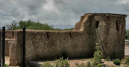
 Reconstruction of Bent's Old Fort.
 -
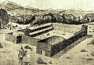
 Reconstruction of Fort Vasquez.
 -
 Marker at site of Fort Saint Vrain.
 -
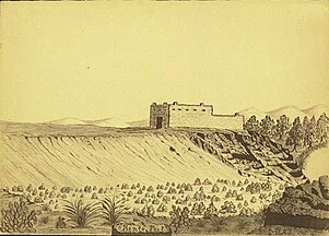
 Sketch of Fort Lupton.
 -
 Sketch of Bent's New Fort.


Maps
-
 A map of the United States from 1828 to 1834.
 -
 A map of the United States in 1836.
 -
 A map of the United States from 1845 to 1846.
 -
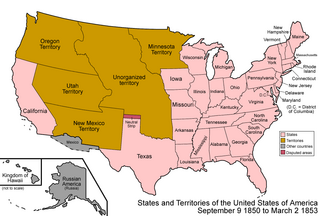 A map of the United States from 1850 to 1853.
 -
 A map of the United States from 1854 to 1858.
 -
 A map of the United States in 1861.
 -
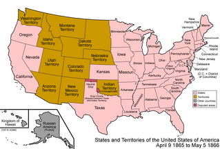 A map of the United States from 1865 to 1866.
 -
 A map of the United States from 1867 to 1868.


See also
- Bibliography of Colorado
- Geography of Colorado
- History of Colorado
- Index of Colorado-related articles
- List of Colorado-related lists
- Outline of Colorado
Notes
- ^ Fort Uncompahgre operated in the northwestern region of Santa Fe de Nuevo México.
- ^ This is the location of the reproduction of the trading post.
- ^ Gantt's Picket Post operated in the unorganized territory of the United States.
- ^ Bent's Fort operated in the unorganized territory of the United States.
- ^ Jimmy's Camp operated in the unorganized territory of the United States until May 30, 1854, when the area was incorporated in the new Territory of Kansas. On January 29, 1861, the area reverted to the unorganized territory of the United States, but 30 days later the area was incorporated in the new Territory of Colorado.
- ^ Fort Cass operated in the unorganized territory of the United States.
- ^ Fort Convenience operated in the unorganized territory of the United States.
- ^ Fort Le Duc operated in the unorganized territory of the United States until May 30, 1854, when the area was incorporated in the new Territory of Kansas.
- ^ Fort Vasquez operated in the unorganized territory of the United States.
- ^ Fort Saint Vrain operated in the unorganized territory of the United States until May 30, 1854, when the area was incorporated in the new Territory of Nebraska.
- ^ Fort Lupton operated in the unorganized territory of the United States.
- ^ Fort Jackson operated in the unorganized territory of the United States.
- ^ Fort Gerry operated in the unorganized territory of the United States.
- ^ Milk Fort operated in the unorganized territory of the United States.
- ^ Fort Davy Crockett operated without authorization in the northwestern region of Santa Fe de Nuevo México.
- ^ This is an approximate location of the trading post.
- ^ Fraeb's Post operated without authorization in the northwestern region of Santa Fe de Nuevo México.
- ^ El Pueblo operated in the unorganized territory of the United States until May 30, 1854, when the area was incorporated in the new Territory of Kansas.
- ^ Bent's New Fort operated in the unorganized territory of the United States until May 30, 1854, when the area was incorporated in the new Territory of Kansas.
- ^ Fort Namaqua operated in Territory of Nebraska until February 28, 1861, when the area was incorporated in the new Territory of Colorado.
- ^ Fort Julesburg operated in Territory of Nebraska until February 28, 1861, when the area was incorporated in the new Territory of Colorado.
References
- ^ "Geographic Names Information System". United States Geological Survey, United States Department of the Interior. Retrieved September 5, 2023.
- ^ Jolie Anderson Gallagher (April 2, 2013). Colorado Forts: Historic Outposts on the Wild Frontier. Arcadia Publishing Incorporated. p. PT8. ISBN 978-1-61423-903-1.
- ^ Jolie Anderson Gallagher (April 2, 2013). Colorado Forts: Historic Outposts on the Wild Frontier. Arcadia Publishing Incorporated. p. PT9. ISBN 978-1-61423-903-1.
- ^ Phil Payette; Pete Payette. "Colorado forts – Fort Huerfano". American Forts Network. Retrieved June 6, 2018.
- ^ Glenn R. Scott (2004) [1975], "Historic Trail Maps of the Pueblo 1° x 2° Quadrangle, Colorado" (PDF), U.S. Geological Survey, Department of the Interior, pp. 4, 50
- ^ Jolie Anderson Gallagher (April 2, 2013). Colorado Forts: Historic Outposts on the Wild Frontier. Arcadia Publishing Incorporated. p. PT10. ISBN 978-1-61423-903-1.
- ^ From the Grave: A Roadside Guide to Colorado's Pioneer Cemeteries. Caxton Press. p. 217. ISBN 978-0-87004-565-3.
- ^ Jessen, Kenneth (July 26, 2014). "Spanish-Speaking Mariano Medina built a fort". Reporter-Herald. Loveland, Colorado. Retrieved June 10, 2018.
- ^ Scott, Glenn R. (1989). "Historic trail maps of the Sterling 1 degree by 2 degrees Quadrangle, northeastern Colorado". United States Department of the Interior, United States Geological Survey. doi:10.3133/i1894. Retrieved July 23, 2021.
External links
Colorado at Wikipedia's sister projects
 Media from Commons
 News from Wikinews
 Quotations from Wikiquote
 Travel information from Wikivoyage
| |||