Missouri Route 80
Route 80 is a state highway in southeastern Missouri. The route is located in northern New Madrid and central Mississippi Counties.

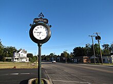
Route 80 in East Prairie
Route description
Route 80's western terminus is at U.S. Route 61/62 near Matthews, which is located midway between Sikeston and New Madrid, with a junction with I-55 located about a mile (1.6 km) to the east. East Prairie is the only other town on the highway. Its eastern terminus is a dead end at the Mississippi River in Belmont.
History
At Belmont, there used to be a ferry connecting Route 80 to Kentucky Route 80, which is a major east–west thoroughfare across southern Kentucky, continuing into Virginia, as Virginia State Route 80. The toll ferry service was discontinued in 1984.
Major intersections

| County | Location | mi | km | Destinations | Notes |
|---|---|---|---|---|---|
| New Madrid | | 0.000 | 0.000 | Western terminus; Eastern terminus of Route H | |
| | 1.505– 1.596 | 2.422– 2.569 | Diamond interchange | ||
| | 1.634 | 2.630 | Northern terminus of Route V | ||
| | 2.566 | 4.130 | Southern terminus of Route AA | ||
| New Madrid–Mississippi county line | | 8.058 | 12.968 | Southern terminus of Route B | |
| Mississippi | | 10.052 | 16.177 | Northern terminus of Route BB | |
| East Prairie | 11.171 | 17.978 | Southern terminus of Route 105 | ||
| | 13.236 | 21.301 | |||
| | 15.263 | 24.563 | Southern terminus of Route 75 | ||
| | 17.817 | 28.674 | Northern terminus of Route AA | ||
| | 21.312 | 34.298 | |||
| | 27.302 | 43.938 | Former ferry, currently a dead end | ||
1.000 mi = 1.609 km; 1.000 km = 0.621 mi
| |||||
References
KML is not from Wikidata
- ^ Missouri Department of Transportation (January 2, 2018). MoDOT HPMAPS (Map). Missouri Department of Transportation. Retrieved January 2, 2018.
- ^ Kentucky Department of State Highways (September 15, 1939). Road Map of Kentucky (PDF) (Map). c. 1:760,320. Frankfort: Kentucky Department of State Highways.
- ^ Kentucky Department of Highways (1964). Kentucky Official Highway Map (PDF) (Map). c. 1:760,320. Frankfort: Kentucky Department of Highways. §§ A6–B6.
- ^ Missouri State Highway Commission (1968). Missouri 1968 Official Highway Map (Map). Scale not given. Jefferson City, MO: Missouri State Highway Commission. § J7 – via Internet Archive.
- ^ Kentucky Transportation Cabinet (1984). Kentucky Official Highway Map and Vacation Guide (PDF) (Map). c. 1:760,320. Frankfort: Kentucky Transportation Cabinet. § A6.
- ^ Kentucky Transportation Cabinet (1985). Kentucky Official Highway Map and Vacation Guide (PDF) (Map). c. 1:760,320. Frankfort: Kentucky Transportation Cabinet. § A6.
- ^ Baughn, James (August 16, 2010). "Belmont, Missouri: Where the pavement really ends". Southeast Missourian. Retrieved January 2, 2018.