Mount Estella
Description
Mount Estella is located within Jasper National Park and is the second-highest peak in the Trident Range of the Canadian Rockies. The town of Jasper is situated 16 kilometres (9.9 mi) to the northeast and the Continental Divide is 11 kilometres (6.8 mi) to the west. The nearest higher neighbor is Majestic Mountain, 1.08 km (0.67 mi) to the south. Precipitation runoff from Estella's east slope drains to the Athabasca River via Portal Creek and the west slope drains to the Miette River via Crescent and Meadow creeks. Topographic relief is significant as the summit rises 1,100 metres (3,609 feet) above Circus Valley in two kilometres (1.2 mile).
History
The mountain's name first appeared in 1916 when Morrison P. Bridgland, a Dominion Land Surveyor was naming many peaks in this area, but the namesake was not recorded. The name appeared in publications as early as 1917. The mountain's toponym was officially adopted in 1951 by the Geographical Names Board of Canada.
The first ascent of the summit was made in 1930 by Newman Diefendorf Waffl. He would perish later that same year on Mount Robson.
Geology
The mountain is composed of sedimentary rock laid down during the Precambrian to Jurassic periods and pushed east and over the top of younger rock during the Laramide orogeny. The strata of this peak have been tilted from horizonal orientation to nearly vertical.
Climate
Based on the Köppen climate classification, Mt. Estella is located in a subarctic climate zone with cold, snowy winters, and mild summers. Winter temperatures can drop below -20 °C with wind chill factors below -30 °C.
Gallery
-
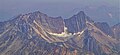 Majestic Mountain (left) and Mount Estella (right)

See also
References
- ^ Putnam, William Lowell (1974). Climber's Guide to the Rocky Mountains of Canada--north. American Alpine Club. p. 214. ISBN 9780930410025.
- ^ "Mount Estella". peakvisor.com. Retrieved 2023-08-03.
- ^ "Mount Estella, Alberta". Peakbagger.com. Retrieved 2023-08-03.
- ^ "Mount Estella". Geographical Names Data Base. Natural Resources Canada. Retrieved 2023-08-03.
- ^ MacLaren, I.S. (2005). Mapper of Mountains M.P. Bridgland in the Canadian Rockies 1902-1930. With Eric Higgs, Gabrielle Zezulka-Mailloux. Edmonton, AB: The University of Alberta Press. ISBN 0-88864-456-6.
- ^ Aubrey, Merrily (2006). Concise Place Names of Alberta. University of Calgary Press. p. 108. ISBN 9781552382103.
- ^ Bridgland, Morrison Parsons (1917). Description of & Guide to Jasper Park. Department of the Interior. p. 89.
- ^ "Mount Estella". cdnrockiesdatabases.ca. Retrieved 2023-08-03.
- ^ Gadd, Ben (2008), Geology of the Rocky Mountains and Columbias
- ^ Peel, M. C.; Finlayson, B. L.; McMahon, T. A. (2007). "Updated world map of the Köppen−Geiger climate classification". Hydrol. Earth Syst. Sci. 11: 1633–1644. ISSN 1027-5606.
External links
- Parks Canada web site: Jasper National Park
- Mount Estella: weather forecast
- Newman Diefendorf Waffl in memoriam
Places adjacent to Mount Estella | ||||||||||||||||
|---|---|---|---|---|---|---|---|---|---|---|---|---|---|---|---|---|
| ||||||||||||||||