Opuksky Nature Reserve
Topography
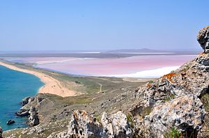
The site is 30 km southwest of the city of kerch, on the south coast. Opuk Mountain in the reserve is the highest point on the Kerch Peninsula, at 185 meters above sea level. It is a table mountain composed of reef limestone, as is much of the karst landscape and offshore islands surrounding it. This distinguishes the reserve from the plains of the Kerch Peninsula around it. To the west of Mount Opuk is a Lake Koiaske, a shallow salt lake, and the larger Uzunlarske Lake. The coastal terrain also features sandy-coquina spits.

Climate and ecoregion
The climate of Opuk is Humid continental climate - Hot summer sub-type (Köppen climate classification Dfa), with large seasonal temperature differentials and a hot summer (at least one month averaging over 22 °C (72 °F), and mild winters. Average temperatures in the reserve range from 2.0 °C (35.6 °F) in January to 23 °C (73 °F) in July, and annual precipitation averages 270 mm.
The reserve is located in the Pontic–Caspian steppe ecoregion, a region that covers an expanse of grasslands stretching from the northern shores of the Black Sea to western Kazakhstan.
Flora and fauna
The higher ground exhibits plants of coastal steppe varieties, the sandy spits support Crambe and other species endemic to the Crimean Peninsula. The reserve is important of it support of birds, with over 200 species having been recorded on the site.
Public use
As a strict nature reserve, Opuk Nature Reserve's primary purpose is protection of nature and scientific study. Public access is limited: mass recreation and construction of facilities is prohibited, as are hunting and fishing. There are three ecological trails on which employees of the reserve conduct guided educational tours.
See also
- Lists of Nature Preserves of Ukraine (class Ia protected areas)
- National Parks of Ukraine (class II protected areas)
- Opuk (mountain)
References
- ^ "Aquatic-coastal complex of Cape Opuk". Ramsar Convention. Retrieved August 10, 2019.
- ^ "Opuksky Nature Reserve" (in Ukrainian). Official Reserve Website. Retrieved June 18, 2019.
- ^ Kottek, M.; Grieser, J.; Beck, C.; Rudolf, B.; Rubel, F. (2006). "World Map of Koppen-Geiger Climate Classification Updated" (PDF). Gebrüder Borntraeger 2006. Retrieved September 14, 2019.
- ^ "Dataset - Koppen climate classifications". World Bank. Retrieved September 14, 2019.
- ^ "Map of Ecoregions 2017". Resolve, using WWF data. Retrieved September 14, 2019.
