Portal:Geography
The Geography Portal

Geography (from Ancient Greek γεωγραφία geōgraphía; combining gê 'Earth' and gráphō 'write') is the study of the lands, features, inhabitants, and phenomena of Earth. Geography is an all-encompassing discipline that seeks an understanding of Earth and its human and natural complexities—not merely where objects are, but also how they have changed and come to be. While geography is specific to Earth, many concepts can be applied more broadly to other celestial bodies in the field of planetary science. Geography has been called "a bridge between natural science and social science disciplines."
Origins of many of the concepts in geography can be traced to Greek Eratosthenes of Cyrene, who may have coined the term "geographia" (c. 276 BC – c. 195/194 BC). The first recorded use of the word γεωγραφία was as the title of a book by Greek scholar Claudius Ptolemy (100 – 170 AD). This work created the so-called "Ptolemaic tradition" of geography, which included "Ptolemaic cartographic theory." However, the concepts of geography (such as cartography) date back to the earliest attempts to understand the world spatially, with the earliest example of an attempted world map dating to the 9th century BCE in ancient Babylon. The history of geography as a discipline spans cultures and millennia, being independently developed by multiple groups, and cross-pollinated by trade between these groups. The core concepts of geography consistent between all approaches are a focus on space, place, time, and scale.
Today, geography is an extremely broad discipline with multiple approaches and modalities. There have been multiple attempts to organize the discipline, including the four traditions of geography, and into branches. Techniques employed can generally be broken down into quantitative and qualitative approaches, with many studies taking mixed-methods approaches. Common techniques include cartography, remote sensing, interviews, and surveying. (Full article...)

Hillsboro (/ˈhɪlzbəroʊ/ HILZ-burr-oh) is a city in the U.S. state of Oregon and is the county seat of Washington County. Situated in the Tualatin Valley on the west side of the Portland metropolitan area, the city hosts many high-technology companies, such as Intel, locally known as the Silicon Forest. The population was 106,447 at the 2020 census, making Hillsboro the fifth-most populous city in Oregon.
Settlers founded a community here in 1842, later named after David Hill, an Oregon politician. Transportation by riverboat on the Tualatin River was part of Hillsboro's settler economy. A railroad reached the area in the early 1870s and an interurban electric railway about four decades later. These railways, as well as highways, aided the slow growth of the city to about 2,000 people by 1910 and about 5,000 by 1950, before the arrival of high-tech companies in the 1980s. (Full article...)

A series of small volcanic earthquakes measuring less than 4.0 on the Richter magnitude scale took place in the sparsely populated Nazko area of the Central Interior of British Columbia, Canada, from October 9, 2007, to June 12, 2008. They occurred just west of Nazko Cone, a small tree-covered cinder cone that last erupted about 7,200 years ago.
No damage or casualties resulted from the Nazko earthquakes, which were too small to be felt by people, but local seismographs recorded them. The earthquake swarm occurred at the eastern end of a known volcanic zone called the Anahim Volcanic Belt. This is an east–west trending line of volcanic formations extending from the Central Coast to the Central Interior of British Columbia. (Full article...)
Henry IV (German: Heinrich IV; 11 November 1050 – 7 August 1106) was Holy Roman Emperor from 1084 to 1105, King of Germany from 1054 to 1105, King of Italy and Burgundy from 1056 to 1105, and Duke of Bavaria from 1052 to 1054. He was the son of Henry III, Holy Roman Emperor—the second monarch of the Salian dynasty—and Agnes of Poitou. After his father's death on 5 October 1056, Henry was placed under his mother's guardianship. She made grants to German aristocrats to secure their support. Unlike her late husband, she could not control the election of the popes, thus the idea of the "liberty of the Church" strengthened during her rule. Taking advantage of her weakness, Archbishop Anno II of Cologne kidnapped Henry in April 1062. He administered Germany until Henry came of age in 1065.
Henry endeavoured to recover the royal estates that had been lost during his minority. He employed low-ranking officials to carry out his new policies, causing discontent in Saxony and Thuringia. Henry crushed a riot in Saxony in 1069 and overcame the rebellion of the Saxon aristocrat Otto of Nordheim in 1071. The appointment of commoners to high office offended German aristocrats, and many of them withdrew from Henry's court. He insisted on his royal prerogative to appoint bishops and abbots, although the reformist clerics condemned this practice as simony (a forbidden sale of church offices). Pope Alexander II blamed Henry's advisors for his acts and excommunicated them in early 1073. Henry's conflicts with the Holy See and the German dukes weakened his position and the Saxons rose up in open rebellion in the summer of 1074. Taking advantage of a quarrel between the Saxon aristocrats and peasantry, he forced the rebels into submission in October 1075. (Full article...)
Valley View is a mid-19th-century Greek Revival residence and farm overlooking the South Branch Potomac River northwest of Romney, West Virginia. The house is atop a promontory where Depot Valley joins the South Branch Potomac River valley.
The Valley View property was part of the South Branch Survey of the Northern Neck Proprietary, a large tract that was inherited by Thomas Fairfax, 6th Lord Fairfax of Cameron, in 1719. It was settled by John Collins and his family in 1749, and acquired by the Parsons family before 1772. The Valley View house was built by James Parsons Jr. in 1855. After the Civil War, Parsons' widow sold the farm to Charles Harmison. His wife, Elizabeth Harmison, inspired by her childhood Virginia home, Western View, and the scenic South Branch Potomac River views, named the farm Valley View. The most recent of a series of owners, the Mayhew family, bought the property in 1979. Valley View's current proprietors, Robert and Kim Mayhew, have restored the historic residence and grounds. (Full article...)

The drift of the Antarctic exploration vessel SY Aurora was an ordeal which lasted 312 days, affecting the Ross Sea party of Sir Ernest Shackleton's Imperial Trans-Antarctic Expedition, 1914–1917. It began when the ship broke loose from its anchorage in McMurdo Sound in May 1915, during a gale. Caught in heavy pack ice and unable to manoeuvre, Aurora, with eighteen men aboard, was carried into the open waters of the Ross Sea and Southern Ocean, leaving ten men stranded ashore with meagre provisions.
Aurora, a 40-year-old former Arctic whaler registered as a steam yacht, had brought the Ross Sea party to Cape Evans in McMurdo Sound in January 1915, to establish its base there in support of Shackleton's proposed transcontinental crossing. When Aurora's captain Aeneas Mackintosh took charge of activities ashore, first officer Joseph Stenhouse assumed command of the ship. Stenhouse's inexperience may have contributed to the choice of an inappropriate winter's berth, although his options were restricted by the instructions of his superiors. After the ship was blown away it suffered severe damage in the ice, including the destruction of its rudder and the loss of its anchors; on several occasions its situation was such that Stenhouse considered abandonment. Efforts to make wireless contact with Cape Evans and, later, with stations in New Zealand and Australia, were unavailing; the drift extended through the southern winter and spring to reach a position north of the Antarctic Circle. In February 1916 the ice broke up, and a month later the ship was free. It was subsequently able to reach New Zealand for repairs and resupply, before returning to Antarctica to rescue the seven surviving members of the shore party. (Full article...)

Australia, officially the Commonwealth of Australia, is a country comprising the mainland of the Australian continent, the island of Tasmania and numerous smaller islands. Australia has a total area of 7,688,287 km (2,968,464 sq mi), making it the sixth-largest country in the world and the largest country by area in Oceania. It is the world's oldest, flattest, and driest inhabited continent, with some of the least fertile soils. It is a megadiverse country, and its size gives it a wide variety of landscapes and climates including deserts in the interior and tropical rainforests along the coast.
The ancestors of Aboriginal Australians began arriving from south-east Asia 50,000 to 65,000 years ago, during the last glacial period. They settled on the continent and formed approximately 250 distinct language groups by the time of European settlement, maintaining some of the longest known continuing artistic and religious traditions in the world. Australia's written history commenced with Dutch exploration of most of the coastline in the 17th-century. British colonisation began in 1788 with the establishment of the penal colony of New South Wales. By the mid-19th century, most of the continent had been explored by European settlers and five additional self-governing British colonies were established, each gaining responsible government by 1890. The colonies federated in 1901, forming the Commonwealth of Australia. This continued a process of increasing autonomy from the United Kingdom, highlighted by the Statute of Westminster Adoption Act 1942, and culminating in the Australia Acts of 1986. (Full article...)
Carrington Moss is a large area of peat bog near Carrington, Greater Manchester, England, south of the River Mersey, 10 miles (16 km) south-west of Manchester. It occupies an area of about 1,100 acres (450 ha). The depth of peat varies between 17 and 20 feet (5.2 and 6.1 m).
Originally an unused area of grouse moorland, the moss was reclaimed in the latter half of the 19th century for farming and the disposal of Manchester's waste. A system of tramways was built to connect it with the Manchester Ship Canal and a nearby railway line. In the Second World War, the land was used as a Starfish site and in the latter half of the 20th century a large industrial complex was built along its northern edge. More recently, several sporting facilities have been built on Carrington Moss. (Full article...)
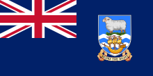
The Falkland Islands (/ˈfɔː(l)klənd, ˈfɒlk-/ FAW(L)K-lənd, FOLK-; Spanish: Islas Malvinas [ˈislas malˈβinas]) is an archipelago in the South Atlantic Ocean on the Patagonian Shelf. The principal islands are about 300 mi (480 km) east of South America's southern Patagonian coast and about 752 mi (1,210 km) from Cape Dubouzet at the northern tip of the Antarctic Peninsula, at a latitude of about 52°S. The archipelago, with an area of 4,700 sq mi (12,000 km), comprises East Falkland, West Falkland, and 776 smaller islands. As a British overseas territory, the Falklands have internal self-governance, but the United Kingdom takes responsibility for their defence and foreign affairs. The capital and largest settlement is Stanley on East Falkland.
The islands are believed to have been uninhabited prior to European discovery in the 17th century. Controversy exists over the Falklands' discovery and subsequent colonisation by Europeans. At various times, the islands have had French, British, Spanish, and Argentine settlements. Britain reasserted its rule in 1833, but Argentina maintains its claim to the islands. In April 1982, Argentine military forces invaded the islands. British administration was restored two months later at the end of the Falklands War. In a 2013 sovereignty referendum, almost all Falklanders voted in favour of remaining a UK overseas territory. The territory's sovereignty status is part of an ongoing dispute between Argentina and the UK. (Full article...)
Joppenbergh Mountain is a nearly 500-foot (152 m) mountain in Rosendale Village, a hamlet in the town of Rosendale, in Ulster County, New York. The mountain is composed of a carbonate bedrock overlain by glacially deposited material. It was named after Rosendale's founder, Jacob Rutsen, and mined throughout the late 19th century for dolomite that was used in the manufacture of natural cement. Extensive mining caused a large cave-in on December 19, 1899, that destroyed equipment and collapsed shafts within Joppenbergh. Though it was feared that several workers had been killed, the collapse happened while all the miners were outside, eating lunch. Since the collapse, the mountain has experienced shaking and periodic rockfalls.
During the late 1930s, Joppenbergh became the site of several ski jumping competitions, which continued until the early 1940s. The original slope was designed by Harold Schelderup for Rosendale's first competition in 1937; Schelderup himself skied that July, after the slope was coated with borax for a summer competition. Several Olympic skiers participated in the competitions. Skiing began again in the 1960s, when a new slope was built on the mountain, and the revived competitions continued until 1971. (Full article...)
Upper Table Rock and Lower Table Rock are two prominent volcanic plateaus located just north of the Rogue River in Jackson County, Oregon, U.S. Created by an andesitic lava flow approximately seven million years ago and shaped by erosion, they now stand about 800 feet (240 m) above the surrounding Rogue Valley. The Table Rocks are jointly owned; The Nature Conservancy is responsible for 3,591 acres (1,453 ha), while the Bureau of Land Management is responsible for 1,280 acres (520 ha).
Native Americans have inhabited the Table Rocks area for at least 15,000 years before European-American settlement. Starting in the mid-19th century during a gold rush, the settlers forced the Takelma tribe away from the Table Rocks and into reservations. The surrounding area was quickly developed. The Table Rock post office was established in 1872, an airstrip was built atop Lower Table Rock in 1948, and a very high frequency omni-directional range (VOR) aviation tower was constructed on Upper Table Rock in the 1960s. The Table Rocks were not protected until the 1970s. (Full article...)

The surrender of the Empire of Japan in World War II was announced by Emperor Hirohito on 15 August and formally signed on 2 September 1945, ending the war. By the end of July 1945, the Imperial Japanese Navy (IJN) was incapable of conducting major operations and an Allied invasion of Japan was imminent. Together with the United Kingdom and China, the United States called for the unconditional surrender of Japan in the Potsdam Declaration on 26 July 1945—the alternative being "prompt and utter destruction". While publicly stating their intent to fight on to the bitter end, Japan's leaders (the Supreme Council for the Direction of the War, also known as the "Big Six") were privately making entreaties to the publicly neutral Soviet Union to mediate peace on terms more favorable to the Japanese. While maintaining a sufficient level of diplomatic engagement with the Japanese to give them the impression they might be willing to mediate, the Soviets were covertly preparing to attack Japanese forces in Manchuria and Korea (in addition to South Sakhalin and the Kuril Islands) in fulfillment of promises they had secretly made to the US and the UK at the Tehran and Yalta Conferences.
On 6 August 1945, at 8:15 am local time, the United States detonated an atomic bomb over the Japanese city of Hiroshima. Sixteen hours later, American President Harry S. Truman called again for Japan's surrender, warning them to "expect a rain of ruin from the air, the like of which has never been seen on this earth." Late on 8 August 1945, in accordance with the Yalta agreements, but in violation of the Soviet–Japanese Neutrality Pact, the Soviet Union declared war on Japan, and soon after midnight on 9 August 1945, the Soviet Union invaded the Japanese puppet state of Manchukuo. Hours later, the United States dropped a second atomic bomb, on the Japanese city of Nagasaki. Emperor Hirohito ordered the Supreme Council for the Direction of the War to accept the terms the Allies had set down in the Potsdam Declaration. After several more days of behind-the-scenes negotiations and a failed coup d'état, Emperor Hirohito gave a recorded radio address across the Empire on 15 August announcing the surrender of Japan to the Allies. (Full article...)
Zhang Heng (Chinese: 張衡; AD 78–139), formerly romanized Chang Heng, was a Chinese polymathic scientist and statesman who lived during the Han dynasty. Educated in the capital cities of Luoyang and Chang'an, he achieved success as an astronomer, mathematician, seismologist, hydraulic engineer, inventor, geographer, cartographer, ethnographer, artist, poet, philosopher, politician, and literary scholar.
Zhang Heng began his career as a minor civil servant in Nanyang. Eventually, he became Chief Astronomer, Prefect of the Majors for Official Carriages, and then Palace Attendant at the imperial court. His uncompromising stance on historical and calendrical issues led to his becoming a controversial figure, preventing him from rising to the status of Grand Historian. His political rivalry with the palace eunuchs during the reign of Emperor Shun (r. 125–144) led to his decision to retire from the central court to serve as an administrator of Hejian Kingdom in present-day Hebei. Zhang returned home to Nanyang for a short time, before being recalled to serve in the capital once more in 138. He died there a year later, in 139. (Full article...)


