Portal:Geography
The Geography Portal

Geography (from Ancient Greek γεωγραφία geōgraphía; combining gê 'Earth' and gráphō 'write') is the study of the lands, features, inhabitants, and phenomena of Earth. Geography is an all-encompassing discipline that seeks an understanding of Earth and its human and natural complexities—not merely where objects are, but also how they have changed and come to be. While geography is specific to Earth, many concepts can be applied more broadly to other celestial bodies in the field of planetary science. Geography has been called "a bridge between natural science and social science disciplines."
Origins of many of the concepts in geography can be traced to Greek Eratosthenes of Cyrene, who may have coined the term "geographia" (c. 276 BC – c. 195/194 BC). The first recorded use of the word γεωγραφία was as the title of a book by Greek scholar Claudius Ptolemy (100 – 170 AD). This work created the so-called "Ptolemaic tradition" of geography, which included "Ptolemaic cartographic theory." However, the concepts of geography (such as cartography) date back to the earliest attempts to understand the world spatially, with the earliest example of an attempted world map dating to the 9th century BCE in ancient Babylon. The history of geography as a discipline spans cultures and millennia, being independently developed by multiple groups, and cross-pollinated by trade between these groups. The core concepts of geography consistent between all approaches are a focus on space, place, time, and scale.
Today, geography is an extremely broad discipline with multiple approaches and modalities. There have been multiple attempts to organize the discipline, including the four traditions of geography, and into branches. Techniques employed can generally be broken down into quantitative and qualitative approaches, with many studies taking mixed-methods approaches. Common techniques include cartography, remote sensing, interviews, and surveying. (Full article...)
 Featured article -
-

Navenby /ˈneɪvənbi/ is a village and civil parish in the North Kesteven district of Lincolnshire, England. Lying 8 miles (13 km) south from Lincoln and 9 miles (14 km) north-northwest from Sleaford, Navenby had a population of 2,128 in the 2011 census and in March 2011, it was named as the 'Best Value Village' in England following a national survey.
A Bronze Age cemetery and the remains of an Iron Age settlement have been discovered in the village. Historians also believe Navenby was a significant staging point on the Roman Ermine Street, as the Romans are reported to have maintained a small base or garrison in the village. Navenby became a market town after receiving a charter from Edward the Confessor in the 11th century. The charter was later renewed by William Rufus, Edward III and Richard II. When the market fell into disuse in the early 19th century, Navenby returned to being a village. (Full article...)

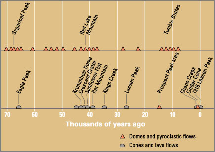
Laguna del Maule is a volcanic field in the Andes mountain range of Chile, close to, and partly overlapping, the Argentina–Chile border. The bulk of the volcanic field is in the Talca Province of Chile's Maule Region. It is a segment of the Southern Volcanic Zone, part of the Andean Volcanic Belt. The volcanic field covers an area of 500 km (190 sq mi) and features at least 130 volcanic vents. Volcanic activity has generated cones, lava domes, lava coulees and lava flows, which surround the Laguna del Maule lake. The field gets its name from the lake, which is also the source of the Maule River.
The field's volcanic activity began 1.5 million years ago during the Pleistocene epoch; such activity has continued into the postglacial and Holocene epoch after glaciers retreated from the area. Postglacial volcanic activity has included eruptions with simultaneous explosive and effusive components, as well as eruptions with only one component. In the postglacial era, volcanic activity has increased at Laguna del Maule, with the volcanic field rapidly inflating during the Holocene. Three major caldera-forming eruptions took place in the volcanic field prior to the last glacial period. The most recent eruptions in the volcanic field took place 2,500 ± 700, 1,400 ± 600 and 800 ± 600 years ago and generated lava flows; today geothermal phenomena occur at Laguna del Maule. Volcanic rocks in the field include basalt, andesite, dacite and rhyolite; the latter along with rhyodacite makes up most of the Holocene rocks. In pre-Columbian times, the field was a regionally important source of obsidian. (Full article...)
The Schichau class consisted of 22 torpedo boats built for the Austro-Hungarian Navy between 1885 and 1891. The class was one of the first torpedo boat classes built for the Austro-Hungarian Navy, and they were initially powered by steam from a single locomotive boiler and were armed with two 37 mm (1.5 in) Hotchkiss guns and two 356 mm (14 in) torpedo tubes. The entire class was reconstructed between 1900 and 1910, when they received two Yarrow boilers and a second funnel.
Ten of the class were converted into minesweepers between 1911 and 1913. One boat was discarded in 1911, with the rest seeing active service as part of local defence forces for the Adriatic naval bases during World War I, with one being lost in the early days of the war. The remaining ten torpedo boats were also converted to minesweepers in 1917, although five still carried torpedoes. After the war, sixteen of the boats were allocated to Italy and four were allocated to the navy of the newly created Kingdom of the Serbs, Croats and Slovenes (later Yugoslavia). Two were commissioned while the other two were used for spare parts. Except for one of the Yugoslav boats which was retained as a training vessel, all of the boats had been discarded by 1929. After capture during the April 1941 Axis invasion of Yugoslavia in World War II, the remaining boat saw service with the Italians and then the Germans. She was lost while in German hands sometime after September 1943. (Full article...)
George Town is the capital of the Malaysian state of Penang. It is the core city of the George Town Conurbation, Malaysia's second largest metropolitan area with a population of 2.84 million and the second highest contributor to the country's GDP. The city proper spans an area of 306 km (118 sq mi) encompassing Penang Island and surrounding islets, and had a population of 794,313 as of 2020.
Initially established as an entrepôt by Francis Light in 1786, George Town serves as the commercial centre for northern Malaysia. According to Euromonitor International and the Economist Intelligence Unit, it has the highest potential for revenue growth among all Malaysian cities and contributed nearly 8 per cent of the country's personal disposable income in 2015, second only to the national capital, Kuala Lumpur. Its technological sector, anchored by hundreds of multinational companies, has made George Town the top exporter in the country. The Penang International Airport links George Town to several regional cities, while a ferry service and two road bridges connect the city to the rest of Peninsular Malaysia. Swettenham Pier is the busiest cruise terminal in the country. (Full article...)

Kigali (Kinyarwanda pronunciation: [ci.ɡɑ́.ɾi]) is the capital and largest city of Rwanda. It is near the nation's geographic centre in a region of rolling hills, with a series of valleys and ridges joined by steep slopes. As a primate city, Kigali is a relatively new city. It has been Rwanda's economic, cultural, and transport hub since it was founded as an administrative outpost in 1907, and became the capital of the country at independence in 1962, shifting focus away from Huye.
In an area controlled by the Kingdom of Rwanda from the 15th century, and then, by the German Empire in the beginning of the 20th century, the city was founded in 1907 when Richard Kandt, the colonial resident, chose the site for his headquarters, citing its central location, views and security. Foreign merchants began to trade in the city during the German era, and Kandt opened some government-run schools for Tutsi Rwandan students. Belgium took control of Rwanda and Burundi during World War I, forming the mandate of Ruanda-Urundi. Kigali remained the seat of colonial administration for Rwanda but Ruanda-Urundi's capital was at Usumbura (now Bujumbura) in Burundi and Kigali remained a small city with a population of just 6,000 at the time of independence. (Full article...)
Ancient Egypt was a civilization of ancient Northeast Africa. It was concentrated along the lower reaches of the Nile River, situated within the contemporary territory of modern-day Egypt. Ancient Egyptian civilization followed prehistoric Egypt and coalesced around 3100 BC (according to conventional Egyptian chronology) with the political unification of Upper and Lower Egypt under Menes (often identified with Narmer). The history of ancient Egypt unfolded as a series of stable kingdoms interspersed by periods of relative instability known as "Intermediate Periods". The various kingdoms fall into one of three categories: the Old Kingdom of the Early Bronze Age, the Middle Kingdom of the Middle Bronze Age, or the New Kingdom of the Late Bronze Age.
Ancient Egypt reached the pinnacle of its power during the New Kingdom, ruling much of Nubia and a sizable portion of the Levant. After this period, it entered an era of slow decline. During the course of its history, ancient Egypt was invaded or conquered by a number of foreign powers, including the Hyksos, the Nubians, the Assyrians, the Achaemenid Persians, and the Macedonians under Alexander the Great. The Greek Ptolemaic Kingdom, formed in the aftermath of Alexander's death, ruled until 30 BC, when, under Cleopatra, it fell to the Roman Empire and became a Roman province. Egypt remained under Roman control until the 640s AD, when it was conquered by the Rashidun Caliphate. (Full article...)
Little Thetford /ˈθɛtfɔːrd/ is a small village in the civil parish of Thetford, 3 miles (5 km) south of Ely in Cambridgeshire, England, about 76 miles (122 km) by road from London. The village is built on a boulder clay island surrounded by flat fenland countryside, typical of settlements in this part of the East of England.
During the Mesolithic era, the fenland basin was mostly dry and forested, although subject to salt and fresh water incursions. The marshes and meres of this fenland may therefore have been difficult to occupy, other than seasonally, but there is evidence of human settlement on the island since the late Neolithic Age; a Bronze Age causeway linked the village with the nearby Barway, to the south-east. An investigation, prior to a 1995 development in the village, discovered a farm and large tile-kiln of Romano-British origin; further investigations uncovered an earlier settlement of the Pre-Roman Iron Age. The Roman road Akeman Street passed through the north-west corner of the parish, and the lost 7th century Anglo-Saxon village of Cratendune may be nearby. (Full article...)
Cerro Blanco (Spanish: [ˈsero ˈβlaŋko], "White Hill") is a caldera in the Andes of the Catamarca Province in Argentina. Part of the Central Volcanic Zone of the Andes, it is a volcano collapse structure located at an altitude of 4,670 metres (15,320 ft) in a depression. The caldera is associated with a less well-defined caldera to the south and several lava domes.
The caldera has been active for the last eight million years, and eruptions have created several ignimbrites. An eruption occurred 73,000 years ago and formed the Campo de la Piedra Pómez ignimbrite layer. About 2,300 ± 160 BCE, the largest known volcanic eruption of the Central Andes, with a VEI-7, occurred at Cerro Blanco, forming the most recent caldera as well as thick ignimbrite layers. About 170 cubic kilometres (41 cu mi) of tephra were erupted then. The volcano has been dormant since then with some deformation and geothermal activity. A major future eruption would put nearby communities to the south at risk. (Full article...)


.jpg)


.jpg)


