Portal:Geography
The Geography Portal

Geography (from Ancient Greek γεωγραφία geōgraphía; combining gê 'Earth' and gráphō 'write') is the study of the lands, features, inhabitants, and phenomena of Earth. Geography is an all-encompassing discipline that seeks an understanding of Earth and its human and natural complexities—not merely where objects are, but also how they have changed and come to be. While geography is specific to Earth, many concepts can be applied more broadly to other celestial bodies in the field of planetary science. Geography has been called "a bridge between natural science and social science disciplines."
Origins of many of the concepts in geography can be traced to Greek Eratosthenes of Cyrene, who may have coined the term "geographia" (c. 276 BC – c. 195/194 BC). The first recorded use of the word γεωγραφία was as the title of a book by Greek scholar Claudius Ptolemy (100 – 170 AD). This work created the so-called "Ptolemaic tradition" of geography, which included "Ptolemaic cartographic theory." However, the concepts of geography (such as cartography) date back to the earliest attempts to understand the world spatially, with the earliest example of an attempted world map dating to the 9th century BCE in ancient Babylon. The history of geography as a discipline spans cultures and millennia, being independently developed by multiple groups, and cross-pollinated by trade between these groups. The core concepts of geography consistent between all approaches are a focus on space, place, time, and scale.
Today, geography is an extremely broad discipline with multiple approaches and modalities. There have been multiple attempts to organize the discipline, including the four traditions of geography, and into branches. Techniques employed can generally be broken down into quantitative and qualitative approaches, with many studies taking mixed-methods approaches. Common techniques include cartography, remote sensing, interviews, and surveying. (Full article...)
 Featured article -
-

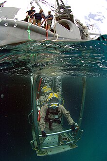
Surface-supplied divers riding a stage to the underwater workplace
Underwater diving, as a human activity, is the practice of descending below the water's surface to interact with the environment. It is also often referred to as diving, an ambiguous term with several possible meanings, depending on context.
Immersion in water and exposure to high ambient pressure have physiological effects that limit the depths and duration possible in ambient pressure diving. Humans are not physiologically and anatomically well-adapted to the environmental conditions of diving, and various equipment has been developed to extend the depth and duration of human dives, and allow different types of work to be done.
In ambient pressure diving, the diver is directly exposed to the pressure of the surrounding water. The ambient pressure diver may dive on breath-hold (freediving) or use breathing apparatus for scuba diving or surface-supplied diving, and the saturation diving technique reduces the risk of decompression sickness (DCS) after long-duration deep dives. Atmospheric diving suits (ADS) may be used to isolate the diver from high ambient pressure. Crewed submersibles can extend depth range to full ocean depth, and remotely controlled or robotic machines can reduce risk to humans. (Full article...) -

A map of Resolution Guyot's bathymetric relief
Resolution Guyot (formerly known as Huevo) is a guyot (tablemount) in the underwater Mid-Pacific Mountains in the Pacific Ocean. It is a circular flat mountain, rising 500 metres (1,600 ft) above the seafloor to a depth of about 1,320 metres (4,330 ft), with a 35-kilometre-wide (22 mi) summit platform. The Mid-Pacific Mountains lie west of Hawaii and northeast of the Marshall Islands, but at the time of its formation, the guyot was located in the Southern Hemisphere.
The guyot was probably formed by a hotspot in today's French Polynesia before plate tectonics shifted it to its present-day location. The Easter, Marquesas, Pitcairn and Society hotspots, among others, may have been involved in the formation of Resolution Guyot. Volcanic activity has been dated to have occurred 107–129 million years ago and formed a volcanic island that was subsequently flattened by erosion. Carbonate deposition commenced, forming an atoll-like structure and a carbonate platform. (Full article...) -
The Italian War of 1542–1546 was a conflict late in the Italian Wars, pitting Francis I of France and Suleiman I of the Ottoman Empire against the Holy Roman Emperor Charles V and Henry VIII of England. The course of the war saw extensive fighting in Italy, France, and the Low Countries, as well as attempted invasions of Spain and England. The conflict was inconclusive and ruinously expensive for the major participants.
The war arose from the failure of the Truce of Nice, which ended the Italian War of 1536–1538, to resolve the long-standing conflict between Charles and Francis—particularly their conflicting claims to the Duchy of Milan. Having found a suitable pretext, Francis once again declared war against his perpetual enemy in 1542. Fighting began at once throughout the Low Countries; the following year saw the Franco-Ottoman alliance's attack on Nice, as well as a series of maneuvers in Northern Italy which culminated in the bloody Battle of Ceresole. Charles and Henry then proceeded to invade France, but the long sieges of Boulogne-sur-Mer and Saint-Dizier prevented a decisive offensive against the French. (Full article...)


Beirut was twice occupied during the Russo-Turkish War of 1768–1774 by squadrons of the Imperial Russian Navy's Mediterranean Fleet, first in June 1772 and second from October 1773 to early 1774, as part of its Levant campaign. Russia's main objective in this campaign was to assist local forces led by Egypt's autonomous ruler, Ali Bey al-Kabir, who was in open rebellion against the Ottoman Empire.
Russia, led by Catherine the Great, was pressing the Ottomans in Europe. Ali took advantage of the Empire's preoccupation with Russia to declare Egypt's independence; in 1771 he sent an army led by Muhammad Bey Abu al-Dhahab to occupy Ottoman territory in the Levant. Abu al-Dhahab unexpectedly returned to challenge Ali for control of Egypt. Ali requested Russian military assistance against both his rival and the Ottomans. When this aid, in the form of a small Russian squadron, arrived in the region, Ali had already fled Egypt and taken refuge in Acre, the power base of his ally, Zahir al-Umar. After helping repel an Ottoman offensive on Sidon, the Russian squadron sailed for Beirut. They bombarded the town in June 1772 and occupied it from June 23 to 28. (Full article...)
.png)
Alodia, also known as Alwa (Greek: Αρουα, Aroua; Arabic: علوة, ʿAlwa), was a medieval kingdom in what is now central and southern Sudan. Its capital was the city of Soba, located near modern-day Khartoum at the confluence of the Blue and White Nile rivers.
Founded sometime after the ancient Kingdom of Kush fell, around 350 AD, Alodia is first mentioned in historical records in 569. It was the last of the three Nubian kingdoms to convert to Christianity in 580, following Nobadia and Makuria. It possibly reached its peak during the 9th–12th centuries when records show that it exceeded its northern neighbor, Makuria, with which it maintained close dynastic ties, in size, military power and economic prosperity. Alodia was a large, multicultural state administered by a powerful king and provincial governors appointed by him. The capital Soba, described as a town of "extensive dwellings and churches full of gold and gardens", prospered as a trading hub. Goods arrived from Makuria, the Middle East, western Africa, India and even China. Literacy in both Nubian and Greek flourished. (Full article...)

The Somerset Levels are a coastal plain and wetland area of Somerset, England, running south from the Mendips to the Blackdown Hills.
The Somerset Levels have an area of about 160,000 acres (650 km) and are bisected by the Polden Hills; the areas to the south are drained by the River Parrett, and the areas to the north by the rivers Axe and Brue. The Mendip Hills separate the Somerset Levels from the North Somerset Levels. The Somerset Levels consist of marine clay "levels" along the coast and inland peat-based "moors"; agriculturally, about 70 per cent is used as grassland and the rest is arable. Willow and teazel are grown commercially and peat is extracted. (Full article...)
.svg)
Australia, officially the Commonwealth of Australia, is a country comprising the mainland of the Australian continent, the island of Tasmania, and numerous smaller islands. It is the largest country by area in Oceania and the sixth-largest country in the world. Australia is the oldest, flattest, and driest inhabited continent, with the least fertile soils. It is a megadiverse country, and its size gives it a wide variety of landscapes and climates including deserts and tropical rainforests.
The ancestors of Aboriginal Australians began arriving from south-east Asia 50,000 to 65,000 years ago, during the last glacial period. They settled on the continent and formed approximately 250 distinct language groups by the time of European settlement, maintaining some of the longest known continuing artistic and religious traditions in the world. Australia's written history commenced with Dutch exploration of most of the coastline in the 17th-century. British colonisation began in 1788 with the establishment of the penal colony of New South Wales. By the mid-19th century, most of the continent had been explored by European settlers and five additional self-governing British colonies were established, each gaining responsible government by 1890. The colonies federated in 1901, forming the Commonwealth of Australia. This continued a process of increasing autonomy from the United Kingdom, highlighted by the Statute of Westminster Adoption Act 1942, and culminating in the Australia Acts of 1986. (Full article...)
The first ruler to hold the title of Grand Duke was Mindaugas. Traditionally he is considered the founder of the state, the one who united the Baltic tribes and established the Duchy. Some scholars, however, challenge this perception, arguing that an organized state existed before Mindaugas, possibly as early as 1183. After quelling an internal war with his nephews, Mindaugas was baptized in 1251, and was crowned as King of Lithuania in 1253. In 1261, he broke the peace with the Livonian Order, perhaps even renouncing Christianity. His assassination in 1263 by Treniota ended the early Christian kingdom in Lithuania. For another 120 years Lithuania would remain a pagan empire, fighting against the Teutonic and Livonian Orders during the Northern Crusades during their attempts to Christianize the land. (Full article...)

The Falkland Islands (/ˈfɔː(l)klənd, ˈfɒlk-/ FAW(L)K-lənd, FOLK-; Spanish: Islas Malvinas [ˈislas malˈβinas]) is an archipelago in the South Atlantic Ocean on the Patagonian Shelf. The principal islands are about 300 mi (480 km) east of South America's southern Patagonian coast and about 752 mi (1,210 km) from Cape Dubouzet at the northern tip of the Antarctic Peninsula, at a latitude of about 52°S. The archipelago, with an area of 4,700 sq mi (12,000 km), comprises East Falkland, West Falkland, and 776 smaller islands. As a British overseas territory, the Falklands have internal self-governance, but the United Kingdom takes responsibility for their defence and foreign affairs. The capital and largest settlement is Stanley on East Falkland.
Controversy exists over the Falklands' discovery and subsequent colonisation by Europeans. At various times, the islands have had French, British, Spanish, and Argentine settlements. Britain reasserted its rule in 1833, but Argentina maintains its claim to the islands. In April 1982, Argentine military forces invaded the islands. British administration was restored two months later at the end of the Falklands War. In a 2013 sovereignty referendum, almost all Falklanders voted in favour of remaining a UK overseas territory. The territory's sovereignty status is part of an ongoing dispute between Argentina and the UK. (Full article...)
.svg)
Canada is a country in North America. Its ten provinces and three territories extend from the Atlantic Ocean to the Pacific Ocean and northward into the Arctic Ocean, making it the world's second-largest country by total area, with the world's longest coastline. Its border with the United States is the world's longest international land border. The country is characterized by a wide range of both meteorologic and geological regions. It is a sparsely inhabited country of just over 41 million people, the vast majority residing south of the 55th parallel in urban areas. Canada's capital is Ottawa and its three largest metropolitan areas are Toronto, Montreal, and Vancouver.
Indigenous peoples have continuously inhabited what is now Canada for thousands of years. Beginning in the 16th century, British and French expeditions explored and later settled along the Atlantic coast. As a consequence of various armed conflicts, France ceded nearly all of its colonies in North America in 1763. In 1867, with the union of three British North American colonies through Confederation, Canada was formed as a federal dominion of four provinces. This began an accretion of provinces and territories and a process of increasing autonomy from the United Kingdom, highlighted by the Statute of Westminster, 1931, and culminating in the Canada Act 1982, which severed the vestiges of legal dependence on the Parliament of the United Kingdom. (Full article...)
Hamilton is a port city in the Canadian province of Ontario. Hamilton has a population of 569,353, and its census metropolitan area, which encompasses Burlington and Grimsby, has a population of 785,184. The city is situated approximately 45 kilometres (28 mi) southwest of Toronto in the Greater Toronto and Hamilton Area (GTHA).
Conceived by George Hamilton when he purchased the Durand farm shortly after the War of 1812, the town of Hamilton became the centre of a densely populated and industrialized region at the west end of Lake Ontario known as the Golden Horseshoe. On January 1, 2001, the current boundaries of Hamilton were created through the amalgamation of the original city with other municipalities of the Regional Municipality of Hamilton–Wentworth. Residents of the city are known as Hamiltonians. (Full article...)
T5 was a sea-going torpedo boat operated by the Royal Yugoslav Navy between 1921 and 1941. Originally 87 F, a 250t-class torpedo boat of the Austro-Hungarian Navy built in 1914–1915, she was armed with two 66 mm (2.6 in) guns and four 450 mm (17.7 in) torpedo tubes, and could carry 10–12 naval mines. She saw active service during World War I, performing convoy, patrol, escort and minesweeping tasks, anti-submarine operations and shore bombardment missions. In 1917 the suffixes of all Austro-Hungarian torpedo boats were removed, and thereafter she was referred to as 87. She was part of the escort force for the Austro-Hungarian dreadnought Szent István during the action that resulted in the sinking of that ship by Italian torpedo boats in June 1918, and rescued many of her crew.
Following Austria-Hungary's defeat in 1918, 87 was allocated to the Navy of the Kingdom of Serbs, Croats and Slovenes, which later became the Royal Yugoslav Navy, and was renamed T5. At the time, she and the seven other 250t-class boats were the only modern sea-going vessels of the fledgling maritime force. During the interwar period, T5 and the rest of the navy were involved in exercises of training and cruises to friendly ports, but activity was limited by reduced naval budgets. The boat was captured by the Italians during the German-led Axis invasion of Yugoslavia in April 1941. After her main armament was modernised, she served with the Royal Italian Navy under her Yugoslav designation, conducting coastal and second-line escort duties in the Adriatic Sea. Following the Italian capitulation in September 1943, she was returned to the Royal Yugoslav Navy-in-exile and continued serving as T5. At the end of the war, she was transferred to the new Yugoslav Navy and served as Cer in guard ship, patrol ship and training ship roles until she was stricken off the naval register in 1963 and scrapped soon after. (Full article...)
Dona Teresa Cristina (14 March 1822 – 28 December 1889), nicknamed "the Mother of the Brazilians", was Empress of Brazil as the consort of Emperor Dom Pedro II from their marriage on 30 May 1843 until 15 November 1889, when the monarchy was abolished. Born a princess of the Kingdom of the Two Sicilies in present-day southern Italy, Teresa Cristina was the daughter of King Don Francesco I (Francis I) of the Italian branch of the House of Bourbon and his wife Maria Isabel (Maria Isabella). It was long believed by historians that the Princess was raised in an ultra-conservative, intolerant atmosphere which resulted in a timid and unassertive character in public and an ability to be contented with very little materially or emotionally. Recent studies revealed a more complex character, who despite having respected the social norms of the era, was able to assert a limited independence due to her strongly opinionated personality as well as her interest in learning, sciences and culture.
The Princess was married by proxy to Pedro II in 1843. Her spouse's expectations had been raised when a portrait was presented that depicted Teresa Cristina as an idealized beauty, but he was displeased by his bride's appearance upon their first meeting later that year. Despite a cold beginning on the part of Pedro, the couple's relationship improved as time passed, due primarily to Teresa Cristina's patience, kindness and generosity. These traits also helped her win the hearts of the Brazilian people, and her distance from political controversies shielded her from criticism. She also sponsored archaeological studies in Italy and Italian immigration to Brazil. (Full article...)
White Deer Hole Creek is a 20.5-mile (33.0 km) tributary of the West Branch Susquehanna River in Clinton, Lycoming and Union counties in the U.S. state of Pennsylvania. A part of the Chesapeake Bay drainage basin, the White Deer Hole Creek watershed drains parts of ten townships. The creek flows east in a valley of the Ridge-and-valley Appalachians, through sandstone, limestone, and shale from the Ordovician, Silurian, and Devonian periods.
As of 2006, the creek and its 67.2-square-mile (174 km) watershed are relatively undeveloped, with 28.4 percent of the watershed given to agriculture and 71.6 percent covered by forest, including part of Tiadaghton State Forest. The western part of White Deer Hole Creek has very high water quality and is the only major creek section in Lycoming County classified as Class A Wild Trout Waters, defined by the Pennsylvania Fish and Boat Commission as "streams which support a population of naturally produced trout of sufficient size and abundance to support a long-term and rewarding sport fishery." The rest of the creek and its major tributary (Spring Creek) are kept stocked. There are opportunities in the watershed for canoeing, hunting, and camping, and trails for hiking and horseback riding. (Full article...)
Upper Pine Bottom State Park is a 5-acre (2.0 ha) Pennsylvania state park in Lycoming County, Pennsylvania in the United States. The park is in Cummings Township on Pennsylvania Route 44 and is surrounded by the Tiadaghton State Forest. It is on Upper Pine Bottom Run, which gave the park its name and is a tributary of Pine Creek. Upper Pine Bottom State Park is in the Pine Creek Gorge, where the streams have cut through five major rock formations from the Devonian and Carboniferous periods.
The earliest recorded inhabitants of the area were the Susquehannocks, followed by the Iroquois, Lenape, and Shawnee. Upper Pine Bottom Run was the site of a furnace for pig iron in 1814, the first sawmill was built on it in 1815, and in 1825 an earlier bridle path across its headwaters became a turnpike. The lumber industry led to the clearcutting of the area in the 19th century. The state forest was started in 1898 and the park was formed from it by 1923 as a Class B public camp. The Civilian Conservation Corps had a camp on the run and improved the park in the 1930s, but it was not transferred to the Bureau of State Parks until 1962. Though it began as a public campsite and once had a picnic pavilion, as of 2017 it is for day use only and its only facilities are a few picnic tables and a parking area. (Full article...)
.jpg)


