Loading
  • 21 Aug, 2019

  • By, Wikipedia

Portal:Geography

The Geography Portal

Geography (from Ancient Greek γεωγραφία geōgraphía; combining 'Earth' and gráphō 'write') is the study of the lands, features, inhabitants, and phenomena of Earth. Geography is an all-encompassing discipline that seeks an understanding of Earth and its human and natural complexities—not merely where objects are, but also how they have changed and come to be. While geography is specific to Earth, many concepts can be applied more broadly to other celestial bodies in the field of planetary science. Geography has been called "a bridge between natural science and social science disciplines."

Origins of many of the concepts in geography can be traced to Greek Eratosthenes of Cyrene, who may have coined the term "geographia" (c. 276 BC – c. 195/194 BC). The first recorded use of the word γεωγραφία was as the title of a book by Greek scholar Claudius Ptolemy (100 – 170 AD). This work created the so-called "Ptolemaic tradition" of geography, which included "Ptolemaic cartographic theory." However, the concepts of geography (such as cartography) date back to the earliest attempts to understand the world spatially, with the earliest example of an attempted world map dating to the 9th century BCE in ancient Babylon. The history of geography as a discipline spans cultures and millennia, being independently developed by multiple groups, and cross-pollinated by trade between these groups. The core concepts of geography consistent between all approaches are a focus on space, place, time, and scale.

Today, geography is an extremely broad discipline with multiple approaches and modalities. There have been multiple attempts to organize the discipline, including the four traditions of geography, and into branches. Techniques employed can generally be broken down into quantitative and qualitative approaches, with many studies taking mixed-methods approaches. Common techniques include cartography, remote sensing, interviews, and surveying. (Full article...)

Featured articles are displayed here, which represent some of the best content on English Wikipedia.

  • Image 3 The Parthian Empire in 94 BC at its greatest extent, during the reign of Mithridates II (r. 124–91 BC) The Parthian Empire (/ˈpɑːrθiən/), also known as the Arsacid Empire (/ˈɑːrsəsɪd/), was a major Iranian political and cultural power centered in ancient Iran from 247 BC to 224 AD. Its latter name comes from its founder, Arsaces I, who led the Parni tribe in conquering the region of Parthia in Iran's northeast, then a satrapy (province) under Andragoras, who was rebelling against the Seleucid Empire. Mithridates I (r. c. 171 – 132 BC) greatly expanded the empire by seizing Media and Mesopotamia from the Seleucids. At its height, the Parthian Empire stretched from the northern reaches of the Euphrates, in what is now central-eastern Turkey, to present-day Afghanistan and western Pakistan. The empire, located on the Silk Road trade route between the Roman Empire in the Mediterranean Basin and the Han dynasty of China, became a center of trade and commerce. The Parthians largely adopted the art, architecture, religious beliefs, and regalia of their culturally heterogeneous empire, which encompassed Persian, Hellenistic, and regional cultures. For about the first half of its existence, the Arsacid court adopted elements of Greek culture, though it eventually saw a gradual revival of Iranian traditions. The Arsacid rulers were titled "King of Kings", claiming inheritance of the Achaemenid Empire; indeed, they accepted many local kings as vassals, although the Achaemenids would have had centrally appointed, albeit largely autonomous, satraps. The court did appoint a small number of satraps, largely outside Iran, but these satrapies were smaller and less powerful than the Achaemenid potentates. With the expansion of Arsacid power, the seat of central government shifted from Nisa to Ctesiphon along the Tigris (south of Baghdad), although several other sites also served as capitals. (Full article...)

    The Parthian Empire (/ˈpɑːrθiən/), also known as the Arsacid Empire (/ˈɑːrsəsɪd/), was a major Iranian political and cultural power centered in ancient Iran from 247 BC to 224 AD. Its latter name comes from its founder, Arsaces I, who led the Parni tribe in conquering the region of Parthia in Iran's northeast, then a satrapy (province) under Andragoras, who was rebelling against the Seleucid Empire. Mithridates I (r.c. 171 – 132 BC) greatly expanded the empire by seizing Media and Mesopotamia from the Seleucids. At its height, the Parthian Empire stretched from the northern reaches of the Euphrates, in what is now central-eastern Turkey, to present-day Afghanistan and western Pakistan. The empire, located on the Silk Road trade route between the Roman Empire in the Mediterranean Basin and the Han dynasty of China, became a center of trade and commerce.

    The Parthians largely adopted the art, architecture, religious beliefs, and regalia of their culturally heterogeneous empire, which encompassed Persian, Hellenistic, and regional cultures. For about the first half of its existence, the Arsacid court adopted elements of Greek culture, though it eventually saw a gradual revival of Iranian traditions. The Arsacid rulers were titled "King of Kings", claiming inheritance of the Achaemenid Empire; indeed, they accepted many local kings as vassals, although the Achaemenids would have had centrally appointed, albeit largely autonomous, satraps. The court did appoint a small number of satraps, largely outside Iran, but these satrapies were smaller and less powerful than the Achaemenid potentates. With the expansion of Arsacid power, the seat of central government shifted from Nisa to Ctesiphon along the Tigris (south of Baghdad), although several other sites also served as capitals. (Full article...)
  • Image 4 Traprock cliffs on Chauncey Peak, Connecticut The Metacomet Ridge, Metacomet Ridge Mountains, or Metacomet Range of southern New England is a narrow and steep fault-block mountain ridge known for its extensive cliff faces, scenic vistas, microclimate ecosystems, and rare or endangered plants. The ridge is an important recreation resource located within 10 miles (16 km) of more than 1.5 million people, offering four long-distance hiking trails and over a dozen parks and recreation areas, including several historic sites. It has been the focus of ongoing conservation efforts because of its natural, historic, and recreational value, involving municipal, state, and national agencies and nearly two dozen non-profit organizations. The Metacomet Ridge extends from Branford, Connecticut, on Long Island Sound, through the Connecticut River Valley region of Massachusetts, to northern Franklin County, Massachusetts, 2 miles (3 km) short of the Vermont and New Hampshire borders for a distance of 100 miles (160 km). It is geologically distinct from the nearby Appalachian Mountains and surrounding uplands, and is composed of volcanic basalt (also known as trap rock) and sedimentary rock in faulted and tilted layers many hundreds of feet thick. In most cases, the basalt layers are dominant, prevalent, and exposed. The ridge rises dramatically from much lower valley elevations, although only 1,200 feet (370 m) above sea level at its highest, with an average summit elevation of 725 feet (221 m). (Full article...)

    The Metacomet Ridge, Metacomet Ridge Mountains, or Metacomet Range of southern New England is a narrow and steep fault-block mountain ridge known for its extensive cliff faces, scenic vistas, microclimate ecosystems, and rare or endangered plants. The ridge is an important recreation resource located within 10 miles (16 km) of more than 1.5 million people, offering four long-distance hiking trails and over a dozen parks and recreation areas, including several historic sites. It has been the focus of ongoing conservation efforts because of its natural, historic, and recreational value, involving municipal, state, and national agencies and nearly two dozen non-profit organizations.

    The Metacomet Ridge extends from Branford, Connecticut, on Long Island Sound, through the Connecticut River Valley region of Massachusetts, to northern Franklin County, Massachusetts, 2 miles (3 km) short of the Vermont and New Hampshire borders for a distance of 100 miles (160 km). It is geologically distinct from the nearby Appalachian Mountains and surrounding uplands, and is composed of volcanic basalt (also known as trap rock) and sedimentary rock in faulted and tilted layers many hundreds of feet thick. In most cases, the basalt layers are dominant, prevalent, and exposed. The ridge rises dramatically from much lower valley elevations, although only 1,200 feet (370 m) above sea level at its highest, with an average summit elevation of 725 feet (221 m). (Full article...)
  • Image 5 Steam on the mountain in July 2007 Nevado del Ruiz (Spanish pronunciation: [neβaðo ðel ˈrwis]), also known as La Mesa de Herveo (English: Mesa of Herveo, the name of the nearby town) is a volcano on the border of the departments of Caldas and Tolima in Colombia, being the highest point of both. It is located about 130 km (81 mi) west of the capital city Bogotá. It is a stratovolcano composed of many layers of lava alternating with hardened volcanic ash and other pyroclastic rocks. Volcanic activity at Nevado del Ruiz began about two million years ago, during the Early Pleistocene or Late Pliocene, with three major eruptive periods. The current volcanic cone formed during the present eruptive period, which began 150,000 years ago. The volcano usually generates Vulcanian to Plinian eruptions, which produce swift-moving currents of hot gas and rock called pyroclastic flows. These eruptions often cause massive lahars (mud and debris flows), which pose a threat to human life and the environment. The impact of such an eruption is increased as the hot gas and lava melt the mountain's snowcap, adding large quantities of water to the flow. On November 13, 1985, a small eruption produced an enormous lahar that buried and destroyed the town of Armero in Tolima, causing an estimated 25,000 deaths. This event later became known as the Armero tragedy—the deadliest lahar in recorded history. Similar but less deadly incidents occurred in 1595 and 1845, consisting of a small explosive eruption followed by a large lahar. (Full article...)

    Nevado del Ruiz (Spanish pronunciation: [neβaðo ðel ˈrwis]), also known as La Mesa de Herveo (English: Mesa of Herveo, the name of the nearby town) is a volcano on the border of the departments of Caldas and Tolima in Colombia, being the highest point of both. It is located about 130 km (81 mi) west of the capital city Bogotá. It is a stratovolcano composed of many layers of lava alternating with hardened volcanic ash and other pyroclastic rocks. Volcanic activity at Nevado del Ruiz began about two million years ago, during the Early Pleistocene or Late Pliocene, with three major eruptive periods. The current volcanic cone formed during the present eruptive period, which began 150,000 years ago.

    The volcano usually generates Vulcanian to Plinian eruptions, which produce swift-moving currents of hot gas and rock called pyroclastic flows. These eruptions often cause massive lahars (mud and debris flows), which pose a threat to human life and the environment. The impact of such an eruption is increased as the hot gas and lava melt the mountain's snowcap, adding large quantities of water to the flow. On November 13, 1985, a small eruption produced an enormous lahar that buried and destroyed the town of Armero in Tolima, causing an estimated 25,000 deaths. This event later became known as the Armero tragedy—the deadliest lahar in recorded history. Similar but less deadly incidents occurred in 1595 and 1845, consisting of a small explosive eruption followed by a large lahar. (Full article...)
  • Image 6 Skegness clock tower and seafront amusements Skegness (/ˌskɛɡˈnɛs/ skeg-NESS) is a seaside town and civil parish in the East Lindsey District of Lincolnshire, England. On the Lincolnshire coast of the North Sea, the town is 43 miles (69 km) east of Lincoln and 22 miles (35 km) north-east of Boston. With a population of 21,128 as of 2021, it is the largest settlement in East Lindsey. It incorporates Winthorpe and Seacroft, and forms a larger built-up area with the resorts of Ingoldmells and Chapel St Leonards to the north. The town is on the A52 and A158 roads, connecting it with Boston and the East Midlands, and Lincoln respectively. Skegness railway station is on the Nottingham to Skegness (via Grantham) line. The original Skegness was situated farther east at the mouth of The Wash. Its Norse name refers to a headland which sat near the settlement. By the 14th century, it was a locally important port for coastal trade. The natural sea defences which protected the harbour eroded in the later Middle Ages, and it was lost to the sea after a storm in the 1520s. Rebuilt along the new shoreline, early modern Skegness was a small fishing and farming village, but from the late 18th century members of the local gentry visited for holidays. The arrival of the railways in 1873 transformed it into a popular seaside resort. This was the intention of The 9th Earl of Scarbrough, who owned most of the land in the vicinity; he built the infrastructure of the town and laid out plots, which he leased to speculative developers. This new Skegness quickly became a popular destination for holiday-makers and day trippers from the East Midlands factory towns. By the interwar years the town was established as one of the most popular seaside resorts in Britain. The layout of the modern seafront dates to this time and holiday camps were built around the town, including the first Butlin's holiday resort which opened in Ingoldmells in 1936. (Full article...)

    Skegness (/ˌskɛɡˈnɛs/ skeg-NESS) is a seaside town and civil parish in the East Lindsey District of Lincolnshire, England. On the Lincolnshire coast of the North Sea, the town is 43 miles (69 km) east of Lincoln and 22 miles (35 km) north-east of Boston. With a population of 21,128 as of 2021, it is the largest settlement in East Lindsey. It incorporates Winthorpe and Seacroft, and forms a larger built-up area with the resorts of Ingoldmells and Chapel St Leonards to the north. The town is on the A52 and A158 roads, connecting it with Boston and the East Midlands, and Lincoln respectively. Skegness railway station is on the Nottingham to Skegness (via Grantham) line.

    The original Skegness was situated farther east at the mouth of The Wash. Its Norse name refers to a headland which sat near the settlement. By the 14th century, it was a locally important port for coastal trade. The natural sea defences which protected the harbour eroded in the later Middle Ages, and it was lost to the sea after a storm in the 1520s. Rebuilt along the new shoreline, early modern Skegness was a small fishing and farming village, but from the late 18th century members of the local gentry visited for holidays. The arrival of the railways in 1873 transformed it into a popular seaside resort. This was the intention of The 9th Earl of Scarbrough, who owned most of the land in the vicinity; he built the infrastructure of the town and laid out plots, which he leased to speculative developers. This new Skegness quickly became a popular destination for holiday-makers and day trippers from the East Midlands factory towns. By the interwar years the town was established as one of the most popular seaside resorts in Britain. The layout of the modern seafront dates to this time and holiday camps were built around the town, including the first Butlin's holiday resort which opened in Ingoldmells in 1936. (Full article...)
  • Image 7 Nevados de Putre, Taapaca volcano (right) Taapaca is a Holocene volcanic complex in northern Chile's Arica y Parinacota Region. Located in the Chilean Andes, it is part of the Central Volcanic Zone of the Andean Volcanic Belt, one of four distinct volcanic chains in South America. The town of Putre lies at the southwestern foot of the volcano. Like other volcanoes of the Central Volcanic Zone, Taapaca formed from the subduction of the Nazca Plate beneath the South America Plate. It lies on the western margin of the Altiplano high plateau, on top of older volcanic and sedimentary units. Taapaca has mainly erupted dacite, in the form of numerous lava domes, although an andesitic stratovolcano is also present. (Full article...)

    Taapaca is a Holocene volcanic complex in northern Chile's Arica y Parinacota Region. Located in the Chilean Andes, it is part of the Central Volcanic Zone of the Andean Volcanic Belt, one of four distinct volcanic chains in South America. The town of Putre lies at the southwestern foot of the volcano.

    Like other volcanoes of the Central Volcanic Zone, Taapaca formed from the subduction of the Nazca Plate beneath the South America Plate. It lies on the western margin of the Altiplano high plateau, on top of older volcanic and sedimentary units. Taapaca has mainly erupted dacite, in the form of numerous lava domes, although an andesitic stratovolcano is also present. (Full article...)
  • Image 8 Hillsboro (/ˈhɪlzbəroʊ/ HILZ-burr-oh) is a city in the U.S. state of Oregon and is the county seat of Washington County. Situated in the Tualatin Valley on the west side of the Portland metropolitan area, the city hosts many high-technology companies, such as Intel, locally known as the Silicon Forest. The population was 106,447 at the 2020 census, making Hillsboro the fifth-most populous city in Oregon. Settlers founded a community here in 1842, later named after David Hill, an Oregon politician. Transportation by riverboat on the Tualatin River was part of Hillsboro's settler economy. A railroad reached the area in the early 1870s and an interurban electric railway about four decades later. These railways, as well as highways, aided the slow growth of the city to about 2,000 people by 1910 and about 5,000 by 1950, before the arrival of high-tech companies in the 1980s. (Full article...)

    Hillsboro (/ˈhɪlzbər/ HILZ-burr-oh) is a city in the U.S. state of Oregon and is the county seat of Washington County. Situated in the Tualatin Valley on the west side of the Portland metropolitan area, the city hosts many high-technology companies, such as Intel, locally known as the Silicon Forest. The population was 106,447 at the 2020 census, making Hillsboro the fifth-most populous city in Oregon.

    Settlers founded a community here in 1842, later named after David Hill, an Oregon politician. Transportation by riverboat on the Tualatin River was part of Hillsboro's settler economy. A railroad reached the area in the early 1870s and an interurban electric railway about four decades later. These railways, as well as highways, aided the slow growth of the city to about 2,000 people by 1910 and about 5,000 by 1950, before the arrival of high-tech companies in the 1980s. (Full article...)
  • Image 9 Sale Town Hall Sale is a town in Trafford, Greater Manchester, England, in the historic county of Cheshire on the south bank of the River Mersey, two miles (three kilometres) south of Stretford, three miles (five kilometres) northeast of Altrincham, and five miles (eight kilometres) southwest of Manchester. In 2021, it had a population of 54,515. Evidence of Stone Age, Roman and Anglo-Saxon activity has previously been discovered locally. In the Middle Ages, Sale was a rural township, linked ecclesiastically with neighbouring Ashton upon Mersey, whose fields and meadows were used for crop and cattle farming. By the 17th century, Sale had a cottage industry manufacturing garthweb, the woven material from which horses' saddle girths were made. (Full article...)

    Sale is a town in Trafford, Greater Manchester, England, in the historic county of Cheshire on the south bank of the River Mersey, two miles (three kilometres) south of Stretford, three miles (five kilometres) northeast of Altrincham, and five miles (eight kilometres) southwest of Manchester. In 2021, it had a population of 54,515.

    Evidence of Stone Age, Roman and Anglo-Saxon activity has previously been discovered locally. In the Middle Ages, Sale was a rural township, linked ecclesiastically with neighbouring Ashton upon Mersey, whose fields and meadows were used for crop and cattle farming. By the 17th century, Sale had a cottage industry manufacturing garthweb, the woven material from which horses' saddle girths were made. (Full article...)
  • Image 10 La Salle's Expedition to Louisiana in 1684, painted in 1844 by Theodore Gudin. La Belle is on the left, Le Joly is in the middle, and L'Aimable is grounded in the distance, right. The French colonization of Texas started when Robert Cavelier de La Salle intended to found the colony at the mouth of the Mississippi River, but inaccurate maps and navigational errors caused his ships to anchor instead 400 miles (640 km) to the west, off the coast of Texas. The colony survived until 1688. The present-day town of Inez is near the fort's site. The colony faced numerous difficulties during its brief existence, including Native American raids, epidemics, and harsh conditions. From that base, La Salle led several expeditions to find the Mississippi River. These did not succeed, but La Salle did explore much of the Rio Grande and parts of East Texas. During one of his absences in 1686, the colony's last ship was wrecked, leaving the colonists unable to obtain resources from the French colonies of the Caribbean. As conditions deteriorated, La Salle realized the colony could survive only with help from the French settlements in Illinois Country to the north, along the Mississippi and Illinois rivers. La Salle's last expedition ended along the Brazos River in early 1687, when he and five of his men were murdered during a mutiny. Although a handful of men reached Illinois Country, help never made it to the fort. Most of the remaining members of the colony were killed during a Karankawa raid in late 1688, though four children survived after being adopted as captives. Although the colony lasted only three years, it established France's claim to possession of the region that is now Texas. The United States later claimed, unsuccessfully, this region as part of the Louisiana Purchase because of the early French colony. (Full article...)
    A painting of a group of ships on the left, sailing into a sunset on the right.
    La Salle's Expedition to Louisiana in 1684, painted in 1844 by Theodore Gudin. La Belle is on the left, Le Joly is in the middle, and L'Aimable is grounded in the distance, right.

    The French colonization of Texas started when Robert Cavelier de La Salle intended to found the colony at the mouth of the Mississippi River, but inaccurate maps and navigational errors caused his ships to anchor instead 400 miles (640 km) to the west, off the coast of Texas. The colony survived until 1688. The present-day town of Inez is near the fort's site. The colony faced numerous difficulties during its brief existence, including Native American raids, epidemics, and harsh conditions. From that base, La Salle led several expeditions to find the Mississippi River. These did not succeed, but La Salle did explore much of the Rio Grande and parts of East Texas.

    During one of his absences in 1686, the colony's last ship was wrecked, leaving the colonists unable to obtain resources from the French colonies of the Caribbean. As conditions deteriorated, La Salle realized the colony could survive only with help from the French settlements in Illinois Country to the north, along the Mississippi and Illinois rivers. La Salle's last expedition ended along the Brazos River in early 1687, when he and five of his men were murdered during a mutiny. Although a handful of men reached Illinois Country, help never made it to the fort. Most of the remaining members of the colony were killed during a Karankawa raid in late 1688, though four children survived after being adopted as captives. Although the colony lasted only three years, it established France's claim to possession of the region that is now Texas. The United States later claimed, unsuccessfully, this region as part of the Louisiana Purchase because of the early French colony. (Full article...)
  • Image 11 An 1899 lithograph of SMS Kurfürst Friedrich Wilhelm SMS Kurfürst Friedrich Wilhelm ("His Majesty's Ship Prince-elector Friedrich Wilhelm") was one of the first ocean-going battleships of the German Kaiserliche Marine (Imperial Navy). The ship was named for Prince-elector (Kurfürst) Friedrich Wilhelm, 17th-century Duke of Prussia and Margrave of Brandenburg. She was the fourth pre-dreadnought of the Brandenburg class, along with her sister ships Brandenburg, Weissenburg, and Wörth. She was laid down in 1890 in the Imperial Dockyard in Wilhelmshaven, launched in 1891, and completed in 1893. The Brandenburg-class battleships carried six large-caliber guns in three twin turrets, as opposed to four guns in two turrets, as was the standard in other navies. Kurfürst Friedrich Wilhelm served as the flagship of the Imperial fleet from her commissioning in 1894 until 1900. She saw limited active duty during her service career with the German fleet due to the relatively peaceful nature of the late 19th and early 20th centuries. As a result, her career focused on training exercises and goodwill visits to foreign ports. These training maneuvers were nevertheless very important to developing German naval tactical doctrine in the two decades before World War I, especially under the direction of Alfred von Tirpitz. She, along with her three sisters, saw only one major overseas deployment, to China in 1900–1901, during the Boxer Uprising. The ship underwent a major modernization in 1904–1905. (Full article...)

    SMS Kurfürst Friedrich Wilhelm ("His Majesty's Ship Prince-elector Friedrich Wilhelm") was one of the first ocean-going battleships of the German Kaiserliche Marine (Imperial Navy). The ship was named for Prince-elector (Kurfürst) Friedrich Wilhelm, 17th-century Duke of Prussia and Margrave of Brandenburg. She was the fourth pre-dreadnought of the Brandenburg class, along with her sister ships Brandenburg, Weissenburg, and Wörth. She was laid down in 1890 in the Imperial Dockyard in Wilhelmshaven, launched in 1891, and completed in 1893. The Brandenburg-class battleships carried six large-caliber guns in three twin turrets, as opposed to four guns in two turrets, as was the standard in other navies.
    Kurfürst Friedrich Wilhelm served as the flagship of the Imperial fleet from her commissioning in 1894 until 1900. She saw limited active duty during her service career with the German fleet due to the relatively peaceful nature of the late 19th and early 20th centuries. As a result, her career focused on training exercises and goodwill visits to foreign ports. These training maneuvers were nevertheless very important to developing German naval tactical doctrine in the two decades before World War I, especially under the direction of Alfred von Tirpitz. She, along with her three sisters, saw only one major overseas deployment, to China in 1900–1901, during the Boxer Uprising. The ship underwent a major modernization in 1904–1905. (Full article...)
  • Image 12 Truman near his lodge in 1980, a few months before his death Harry R. Truman (October 1896 – May 18, 1980) was an American businessman, bootlegger, and prospector. He lived near Mount St. Helens, an active volcano in the state of Washington, and was the owner and caretaker of Mount St. Helens Lodge at Spirit Lake near the base of the mountain. Truman came to fame as a folk hero in the weeks leading up to the volcano's 1980 eruption after refusing to leave his home despite evacuation orders. He was killed by a pyroclastic flow that overtook his lodge and buried the site under 150 ft (46 m) of volcanic debris. After Truman's death, his family and friends reflected on his love for the mountain. In 1981, Art Carney portrayed Truman in the docudrama film St. Helens. He was commemorated in a book by his niece, and also in various pieces of music, including songs by Headgear, Billy Jonas, and Shawn Wright and the Brothers Band. (Full article...)

    Harry R. Truman (October 1896 – May 18, 1980) was an American businessman, bootlegger, and prospector. He
    lived near Mount St. Helens, an active volcano in the state of Washington, and was the owner and caretaker of Mount St. Helens Lodge at Spirit Lake near the base of the mountain. Truman came to fame as a folk hero in the weeks leading up to the volcano's 1980 eruption after refusing to leave his home despite evacuation orders. He was killed by a pyroclastic flow that overtook his lodge and buried the site under 150 ft (46 m) of volcanic debris.

    After Truman's death, his family and friends reflected on his love for the mountain. In 1981, Art Carney portrayed Truman in the docudrama film St. Helens. He was commemorated in a book by his niece, and also in various pieces of music, including songs by Headgear, Billy Jonas, and Shawn Wright and the Brothers Band. (Full article...)
  • Image 13 Core Western Ganga Territory Western Ganga was an important ruling dynasty of ancient Karnataka in India which lasted from about 350 to 1000 CE. They are known as "Western Gangas" to distinguish them from the Eastern Gangas who in later centuries ruled over Kalinga (modern Odisha and Northern Andhra Pradesh). The general belief is that the Western Gangas began their rule during a time when multiple native clans asserted their freedom due to the weakening of the Pallava empire in South India, a geo-political event sometimes attributed to the southern conquests of Samudra Gupta. The Western Ganga sovereignty lasted from about 350 to 550 CE, initially ruling from Kolar and later, moving their capital to Talakadu on the banks of the Kaveri River in modern Mysore district. After the rise of the imperial Chalukyas of Badami, the Gangas accepted Chalukya overlordship and fought for the cause of their overlords against the Pallavas of Kanchi. The Chalukyas were replaced by the Rashtrakutas of Manyakheta in 753 CE as the dominant power in the Deccan. After a century of struggle for autonomy, the Western Gangas finally accepted Rashtrakuta overlordship and successfully fought alongside them against their foes, the Chola Dynasty of Tanjavur. In the late 10th century, north of Tungabhadra river, the Rashtrakutas were replaced by the emerging Western Chalukya Empire and the Chola Dynasty saw renewed power south of the Kaveri river. The defeat of the Western Gangas by Cholas around 1000 resulted in the end of the Ganga influence over the region. (Full article...)

    Western Ganga was an important ruling dynasty of ancient Karnataka in India which lasted from about 350 to 1000 CE. They are known as "Western Gangas" to distinguish them from the Eastern Gangas who in later centuries ruled over Kalinga (modern Odisha and Northern Andhra Pradesh). The general belief is that the Western Gangas began their rule during a time when multiple native clans asserted their freedom due to the weakening of the Pallava empire in South India, a geo-political event sometimes attributed to the southern conquests of Samudra Gupta. The Western Ganga sovereignty lasted from about 350 to 550 CE, initially ruling from Kolar and later, moving their capital to Talakadu on the banks of the Kaveri River in modern Mysore district.

    After the rise of the imperial Chalukyas of Badami, the Gangas accepted Chalukya overlordship and fought for the cause of their overlords against the Pallavas of Kanchi. The Chalukyas were replaced by the Rashtrakutas of Manyakheta in 753 CE as the dominant power in the Deccan. After a century of struggle for autonomy, the Western Gangas finally accepted Rashtrakuta overlordship and successfully fought alongside them against their foes, the Chola Dynasty of Tanjavur. In the late 10th century, north of Tungabhadra river, the Rashtrakutas were replaced by the emerging Western Chalukya Empire and the Chola Dynasty saw renewed power south of the Kaveri river. The defeat of the Western Gangas by Cholas around 1000 resulted in the end of the Ganga influence over the region. (Full article...)
  • Image 14 SNAE expedition ship Scotia, in the ice at Laurie Island, South Orkneys, 1903–1904 The Scottish National Antarctic Expedition (SNAE), 1902–1904, was organised and led by William Speirs Bruce, a natural scientist and former medical student from the University of Edinburgh. Although overshadowed in terms of prestige by Robert Falcon Scott's concurrent Discovery Expedition, the SNAE completed a full programme of exploration and scientific work. Its achievements included the establishment of a staffed meteorological station, the first in Antarctic territory, and the discovery of new land to the east of the Weddell Sea. Its large collection of biological and geological specimens, together with those from Bruce's earlier travels, led to the establishment of the Scottish Oceanographical Laboratory in 1906. Bruce had spent most of the 1890s engaged on expeditions to the Antarctic and Arctic regions, and by 1899 was Britain's most experienced polar scientist. In March of that year, he applied to join the Discovery Expedition; however, his proposal to extend that expedition's field of work into the Weddell Sea quadrant, using a second ship, was dismissed as "mischievous rivalry" by Royal Geographical Society (RGS) president Sir Clements Markham. Bruce reacted by obtaining independent finance; his venture was supported and promoted by the Royal Scottish Geographical Society. (Full article...)
    Rear view of a three-masted sailing ship with all sails furled, lying in an ice-covered sea.
    SNAE expedition ship Scotia, in the ice at Laurie Island, South Orkneys, 1903–1904


    The Scottish National Antarctic Expedition (SNAE), 1902–1904, was organised and led by William Speirs Bruce, a natural scientist and former medical student from the University of Edinburgh. Although overshadowed in terms of prestige by Robert Falcon Scott's concurrent Discovery Expedition, the SNAE completed a full programme of exploration and scientific work. Its achievements included the establishment of a staffed meteorological station, the first in Antarctic territory, and the discovery of new land to the east of the Weddell Sea. Its large collection of biological and geological specimens, together with those from Bruce's earlier travels, led to the establishment of the Scottish Oceanographical Laboratory in 1906.

    Bruce had spent most of the 1890s engaged on expeditions to the Antarctic and Arctic regions, and by 1899 was Britain's most experienced polar scientist. In March of that year, he applied to join the Discovery Expedition; however, his proposal to extend that expedition's field of work into the Weddell Sea quadrant, using a second ship, was dismissed as "mischievous rivalry" by Royal Geographical Society (RGS) president Sir Clements Markham. Bruce reacted by obtaining independent finance; his venture was supported and promoted by the Royal Scottish Geographical Society. (Full article...)
  • Image 15 Bulgaria, officially the Republic of Bulgaria, is a country in Southeast Europe. It is situated on the eastern portion of the Balkans directly south of the Danube river and west of the Black Sea. Bulgaria is bordered by Greece and Turkey to the south, Serbia and North Macedonia to the west, and Romania to the north. It covers a territory of 110,994 square kilometres (42,855 sq mi) and is the sixteenth-largest country in Europe. Sofia is the nation's capital and largest city; other major cities include Burgas, Plovdiv, and Varna. One of the earliest societies in the lands of modern-day Bulgaria was the Karanovo culture (6,500 BC). In the 6th to 3rd century BC, the region was a battleground for ancient Thracians, Persians, Celts and Macedonians; stability came when the Roman Empire conquered the region in AD 45. After the Roman state splintered, tribal invasions in the region resumed. Around the 6th century, these territories were settled by the early Slavs. The Bulgars, led by Asparuh, attacked from the lands of Old Great Bulgaria and permanently invaded the Balkans in the late 7th century. They established the First Bulgarian Empire, victoriously recognised by treaty in 681 AD by the Byzantine Empire. It dominated most of the Balkans and significantly influenced Slavic cultures by developing the Cyrillic script. The First Bulgarian Empire lasted until the early 11th century, when Byzantine emperor Basil II conquered and dismantled it. A successful Bulgarian revolt in 1185 established a Second Bulgarian Empire, which reached its apex under Ivan Asen II (1218–1241). After numerous exhausting wars and feudal strife, the empire disintegrated and in 1396 fell under Ottoman rule for nearly five centuries. (Full article...)

    Bulgaria, officially the Republic of Bulgaria, is a country in Southeast Europe. It is situated on the eastern portion of the Balkans directly south of the Danube river and west of the Black Sea. Bulgaria is bordered by Greece and Turkey to the south, Serbia and North Macedonia to the west, and Romania to the north. It covers a territory of 110,994 square kilometres (42,855 sq mi) and is the sixteenth-largest country in Europe. Sofia is the nation's capital and largest city; other major cities include Burgas, Plovdiv, and Varna.

    One of the earliest societies in the lands of modern-day Bulgaria was the Karanovo culture (6,500 BC). In the 6th to 3rd century BC, the region was a battleground for ancient Thracians, Persians, Celts and Macedonians; stability came when the Roman Empire conquered the region in AD 45. After the Roman state splintered, tribal invasions in the region resumed. Around the 6th century, these territories were settled by the early Slavs. The Bulgars, led by Asparuh, attacked from the lands of Old Great Bulgaria and permanently invaded the Balkans in the late 7th century. They established the First Bulgarian Empire, victoriously recognised by treaty in 681 AD by the Byzantine Empire. It dominated most of the Balkans and significantly influenced Slavic cultures by developing the Cyrillic script. The First Bulgarian Empire lasted until the early 11th century, when Byzantine emperor Basil II conquered and dismantled it. A successful Bulgarian revolt in 1185 established a Second Bulgarian Empire, which reached its apex under Ivan Asen II (1218–1241). After numerous exhausting wars and feudal strife, the empire disintegrated and in 1396 fell under Ottoman rule for nearly five centuries. (Full article...)
  • More featured articles

    Vital articles Vital article

    Vital articles to understand Geography.

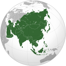
    Asia (/ˈʒə/ AY-zhə, UK also /ˈʃə/ AY-shə) is the largest continent in the world by both land area and population. It covers an area of more than 44 million square kilometers, about 30% of Earth's total land area and 8% of Earth's total surface area. The continent, which has long been home to the majority of the human population, was the site of many of the first civilizations. Its 4.7 billion people constitute roughly 60% of the world's population. (Full article...)

    Other vital articles

    Get involved

    For editor resources and to collaborate with other editors on improving Wikipedia's Geography-related articles, visit WikiProject Geography.


    Here are some tasks awaiting attention:

    Selected pictures

    Featured biography articles in geography

    Emery Molyneux (/ˈɛməri ˈmɒlɪn/ EM-ər-ee MOL-in-oh; died June 1598) was an English Elizabethan maker of globes, mathematical instruments and ordnance. His terrestrial and celestial globes, first published in 1592, were the first to be made in England and the first to be made by an Englishman.

    Molyneux was known as a mathematician and maker of mathematical instruments such as compasses and hourglasses. He became acquainted with many prominent men of the day, including the writer Richard Hakluyt and the mathematicians Robert Hues and Edward Wright. He also knew the explorers Thomas Cavendish, Francis Drake, Walter Raleigh and John Davis. Davis probably introduced Molyneux to his own patron, the London merchant William Sanderson, who largely financed the construction of the globes. When completed, the globes were presented to Elizabeth I. Larger globes were acquired by royalty, noblemen and academic institutions, while smaller ones were purchased as practical navigation aids for sailors and students. The globes were the first to be made in such a way that they were unaffected by the humidity at sea, and they came into general use on ships. (Full article...)

    More featured biographies

    Did you know

    Did you know it about Geography?

    Places around you

    You can read about interesting Wikipedia articles about places around you.

    Special:Nearby

    This following Geography-related articles is a most visited articles of WikiProject Geography, See complete list at Wikipedia:WikiProject Geography/Popular pages.

  • Image 4 Hong Kong is a special administrative region of the People's Republic of China. With 7.4 million residents of various nationalities in a 1,104-square-kilometre (426 sq mi) territory, Hong Kong is the fourth most densely populated region in the world. (Full article...)

    Hong Kong is a special administrative region of the People's Republic of China. With 7.4 million residents of various nationalities in a 1,104-square-kilometre (426 sq mi) territory, Hong Kong is the fourth most densely populated region in the world. (Full article...)
  • Image 5 Dymaxion map of the world with the 30 largest countries and territories by area This is a list of the world's countries and their dependencies by land, water, and total area, ranked by total area. (Full article...)
    Dymaxion map of the world with the 30 largest countries and territories by area

    This is a list of the world's countries and their dependencies by land, water, and total area, ranked by total area. (Full article...)
  • Image 6 River Thames and Tower Bridge with The Shard and Southwark (left), and Tower of London and City of London (right) London is the capital and largest city of both England and the United Kingdom, with a population of 8,866,180 in 2022. The wider metropolitan area is the largest in Western Europe, with a population of 14.9 million. London stands on the River Thames in southeast England, at the head of a 50-mile (80 km) estuary down to the North Sea, and has been a major settlement for nearly 2,000 years. Its ancient core and financial centre, the City of London, was founded by the Romans as Londinium and has retained its medieval boundaries. The City of Westminster, to the west of the City of London, has been the centuries-long host of the national government and parliament. London grew rapidly in the 19th century, becoming the world's largest city at the time. Since the 19th century, the name "London" has referred to the metropolis around the City of London, historically split between the counties of Middlesex, Essex, Surrey, Kent, and Hertfordshire, which since 1965 has largely comprised the administrative area of Greater London, governed by 33 local authorities and the Greater London Authority. (Full article...)

    London is the capital and largest city of both England and the United Kingdom, with a population of 8,866,180 in 2022. The wider metropolitan area is the largest in Western Europe, with a population of 14.9 million. London stands on the River Thames in southeast England, at the head of a 50-mile (80 km) estuary down to the North Sea, and has been a major settlement for nearly 2,000 years. Its ancient core and financial centre, the City of London, was founded by the Romans as Londinium and has retained its medieval boundaries. The City of Westminster, to the west of the City of London, has been the centuries-long host of the national government and parliament. London grew rapidly in the 19th century, becoming the world's largest city at the time. Since the 19th century, the name "London" has referred to the metropolis around the City of London, historically split between the counties of Middlesex, Essex, Surrey, Kent, and Hertfordshire, which since 1965 has largely comprised the administrative area of Greater London, governed by 33 local authorities and the Greater London Authority. (Full article...)
  • Image 7 Cartogram of the world's population in 2018; each square represents 500,000 people. This is a list of countries and dependencies by population. It includes sovereign states, inhabited dependent territories and, in some cases, constituent countries of sovereign states, with inclusion within the list being primarily based on the ISO standard ISO 3166-1. For instance, the United Kingdom is considered a single entity, while the constituent countries of the Kingdom of the Netherlands are considered separately. In addition, this list includes certain states with limited recognition not found in ISO 3166-1. Also given in a percentage is each country's population compared with the world population, which the United Nations estimates at 8.119 billion as of 2024. (Full article...)
    Cartogram of the world's population in 2018; each square represents 500,000 people.


    This is a list of countries and dependencies by population. It includes sovereign states, inhabited dependent territories and, in some cases, constituent countries of sovereign states, with inclusion within the list being primarily based on the ISO standard ISO 3166-1. For instance, the United Kingdom is considered a single entity, while the constituent countries of the Kingdom of the Netherlands are considered separately. In addition, this list includes certain states with limited recognition not found in ISO 3166-1. Also given in a percentage is each country's population compared with the world population, which the United Nations estimates at 8.119 billion as of 2024. (Full article...)
  • Image 8 Generation X (often shortened to Gen X) is the demographic cohort following the Baby Boomers and preceding Millennials. Researchers and popular media often use the mid-1960s as its starting birth years and the late 1970s as its ending birth years, with the generation being generally defined as people born from 1965 to 1980. By this definition and U.S. Census data, there are 65.2 million Gen Xers in the United States as of 2019. Most of Generation X are the children of the Silent Generation and early Baby Boomers; Xers are also often the parents of Millennials and Generation Z. (Full article...)
    Generation X (often shortened to Gen X) is the demographic cohort following the Baby Boomers and preceding Millennials. Researchers and popular media often use the mid-1960s as its starting birth years and the late 1970s as its ending birth years, with the generation being generally defined as people born from 1965 to 1980. By this definition and U.S. Census data, there are 65.2 million Gen Xers in the United States as of 2019. Most of Generation X are the children of the Silent Generation and early Baby Boomers; Xers are also often the parents of Millennials and Generation Z. (Full article...)
  • Image 9 The United Nations uses three definitions for what constitutes a city, as not all cities in all jurisdictions are classified using the same criteria. Cities may be defined as the cities proper, the extent of their urban area, or their metropolitan regions. (Full article...)
    The United Nations uses three definitions for what constitutes a city, as not all cities in all jurisdictions are classified using the same criteria. Cities may be defined as the cities proper, the extent of their urban area, or their metropolitan regions. (Full article...)
  • Image 10 National Mall Washington, D.C., formally the District of Columbia and commonly known as Washington or D.C., is the capital city and federal district of the United States. The city is on the Potomac River, across from Virginia, and shares land borders with Maryland to its north and east. It was named for George Washington, the first president of the United States. The district is named for Columbia, the female personification of the nation. (Full article...)

    Washington, D.C., formally the District of Columbia and commonly known as Washington or D.C., is the capital city and federal district of the United States. The city is on the Potomac River, across from Virginia, and shares land borders with Maryland to its north and east. It was named for George Washington, the first president of the United States. The district is named for Columbia, the female personification of the nation. (Full article...)
  • Click to enlarge and view description.

    Main articles

    CategoriesCategories

    Select [►] to view subcategories.

    Associated Wikimedia

    The following Wikimedia Foundation sister projects provide more on this subject:

    Discover Wikipedia using portals
    Retrieved from "https://en.wikipedia.org/w/index.php?title=Portal:Geography&oldid=1202464975"