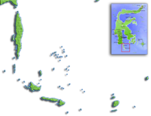
Pulau Bonerate
Islands

- Selayar Island
- Pulau Pulasi
- Pulau Tambalongang
- Pulau Tanahjampea
- Pulau Batu
- Pulau Kayuadi
- Pulau Panjang
- Macan Islands Islands include Latondu, Rajuni, Timabo, Pasi Tallu, and Taka Lamungan.
- Pulau Kalao
- Pulau Bonerate
- Bahuluang
The Selayar Strait (Selat Selayar) is more than 100 fathoms deep and, with a strong current, is dangerous for native ships to navigate. The strata of Selayar Island are all sedimentary rocks: coraline limestone, occasionally sandstone; everywhere, except in the north and north-west, covered by a fertile soil. The watershed is a chain running throughout the island from N. to S., reaching in Bontona Haru 5840 ft.,\ and sloping steeply to the east coast.
People
The population, mainly a mixture of Makasars, Bugis and the natives of Luvu and Buton, is estimated in mid 2021 at 89,147 on the main island and 48,827 on the islands to the southeast of it. They speak the Makassar language and are for the most part nominally Muslims (though many non-Muslim customs survive) and support themselves by agriculture, fishing, seafaring, trade, the preparation of salt (on the south coast) and weaving. Raw and prepared cotton, tobacco, trepang, tortoise-shell, coconuts and coconut oil, and salt are exported. There is frequent movement between the area and other parts of Sulawesi as well as to other parts Indonesia. For that reason, and also because of its excellent horses and numerous water buffaloes, the Saleyar Islands are often compared with Madura, being of the same importance to Sulawesi as is Madura to Java.
References
- ^ Andi Hajramurni, 'Discovering enchanting Selayar, South Sulawesi', The Jakarta Post, 3 January 2012.
- ^ Badan Pusat Statistik, Jakarta, 2023.
- ^ Agung Parameswara, 'Nature, culture & history', The Jakarta Post, 1 December 2012.
- ^ Andi Hajramurni, 'Taka Bonerate offering an undersea paradise', The Jakarta Post Travel, 3 January 2012.
This article incorporates text from a publication now in the public domain: Chisholm, Hugh, ed. (1911). "Saleyer". Encyclopædia Britannica. Vol. 24 (11th ed.). Cambridge University Press. p. 67. 6°0′S 120°30′E / 6.000°S 120.500°E