Třemošnice
Administrative division
Třemošnice consists of eight municipal parts (in brackets population according to the 2021 census):
- Třemošnice (2,491)
- Hedvikov (0)
- Kubíkovy Duby (15)
- Lhůty (16)
- Podhradí (66)
- Skoranov (99)
- Starý Dvůr (100)
- Závratec (117)
Etymology
The name Třemošnice evolved from the word střemcha, i.e. 'bird cherry'.
Geography
Třemošnice is located about 17 kilometres (11 mi) southwest of Chrudim and 22 km (14 mi) southwest of Pardubice. It lies on the border between the Iron Mountains and Central Elbe Table. The highest point is the mountain Bučina at 606 m (1,988 ft) above sea level.
History
The first written mention of Třemošnice is from 1564. A fortress was built in 1610, which was rebuilt into a small castle in 1750. In 1816, an ironworks was established, which led to an increase in the population. In 1882, the railway was built.
Demographics
|
|
| ||||||||||||||||||||||||||||||||||||||||||||||||||||||
| Source: Censuses | ||||||||||||||||||||||||||||||||||||||||||||||||||||||||
Transport
Třemošnice is the starting point of the railway line to Čáslav.
Sights

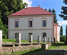
Třemošnice is poor in monuments. The late Baroque Třemošnice Castle is privately owned and its interiors were converted into apartments.
Notable people
- Hermann Zwierzina (1825–1873), the first mayor of Ostrava
Gallery
-
Train station
-
Town hall
-
Gallery and library
References
- ^ "Population of Municipalities – 1 January 2024". Czech Statistical Office. 2024-05-17.
- ^ "Public Census 2021 – basic data". Public Database (in Czech). Czech Statistical Office. 2022.
- ^ Profous, Antonín (1957). Místní jména v Čechách IV: S–Ž (in Czech). pp. 371–372.
- ^ "Historie" (in Czech). Město Třemošnice. Retrieved 2021-10-20.
- ^ "Historický lexikon obcí České republiky 1869–2011" (in Czech). Czech Statistical Office. 2015-12-21.
- ^ "Population Census 2021: Population by sex". Public Database. Czech Statistical Office. 2021-03-27.
- ^ "Detail stanice Třemošnice" (in Czech). České dráhy. Retrieved 2024-06-13.
- ^ "Zámek" (in Czech). Město Třemošnice. Retrieved 2022-07-12.


