Trenggalek
This regency has an area of 1,261.40 km and had a population of 674,411 residents at the 2010 Census and 731,125 at the 2020 Census; the official estimate as of mid-2023 was 756,109. It is located on the southern shore of East Java and is surrounded by three regencies: Ponorogo Regency to the northwest; Pacitan Regency to the southwest; and Tulungagung Regency to the east. The administrative centre is located in the district (kecamatan) of Trenggalek.
Geography
Trenggalek is a regency that is located on the southern shore of Java island and has the following geographical boundaries:
- To the northwest: Ponorogo Regency;
- To the southwest: Pacitan Regency;
- To the east: Tulungagung Regency;
- To the south: Indian Ocean, and
- To the north: Mount Wilis.
Administrative districts
The Regency is divided into fourteen districts (kecamatan), tabulated below with their areas and their population totals from the 2010 Census and the 2020 Census, together with the official estimates as of mid-2023. The table also includes the locations of the district headquarters, the number of administrative villages in each district (totaling 152 rural desa and 5 urban kelurahan - the latter all in Trenggalek (town) District), and its postal codes.
| Kode Wilayah |
Name of District (kecamatan) |
Area in km |
Pop'n Census 2010 |
Pop'n Census 2020 |
Pop'n Estimate mid 2023 |
Admin centre |
No. of villages |
Post codes |
|---|---|---|---|---|---|---|---|---|
| 35.03.01 | Panggul | 131.56 | 69,325 | 78,344 | 81,492 | Wonocoyo | 17 | 66364 |
| 35.03.02 | Munjungan | 154.80 | 46,916 | 52,908 | 54,498 | Munjungan | 11 | 66365 |
| 35.03.08 | Watulimo | 154.44 | 62,625 | 70,002 | 72,855 | Prigi | 12 | 66382 |
| 35.03.07 | Kampak | 79.00 | 35,743 | 37,201 | 38,453 | Bendoagung | 7 | 66373 |
| 35.03.04 | Dongko | 141.20 | 59,248 | 65,505 | 68,272 | Dongko | 10 | 66363 |
| 35.03.03 | Pule | 118.12 | 50,908 | 55,822 | 57,843 | Pule | 10 | 66362 |
| 35.03.06 | Karangan | 50.92 | 45,432 | 49,930 | 50,853 | Karangan | 12 | 66361 |
| 35.03.14 | Suruh | 50.72 | 24,546 | 26,028 | 26,795 | Suruh | 7 | 66360 |
| 35.03.10 | Gandusari | 54.96 | 49,082 | 52,560 | 54,167 | Gandusari | 11 | 66372 |
| 35.03.13 | Durenan | 57.16 | 48,985 | 51,320 | 51,917 | Kendalrejo | 14 | 66381 |
| 35.03.12 | Pogalan | 41.80 | 47,951 | 52,234 | 53,737 | Ngadirenggo | 10 | 66371 |
| 35.03.11 | Trenggalek (town) |
61.16 | 62,606 | 64,306 | 66,887 | Ngantru | 15 | 66311 - 66319 |
| 35.03.05 | Tugu | 74.72 | 45,764 | 47,829 | 49,749 | Gondang | 15 | 66352 |
| 35.03.09 | Bendungan | 90.84 | 25,280 | 27,136 | 28,591 | Dompyong | 8 | 66351 |
| Totals | 1,261,40 | 674,411 | 731,125 | 756,109 | 157 |
Notes: (a) including 11 small offshore islands. (b) including 23 small offshore islands. (c) including 23 small offshore islands.
(d) comprising 5 urban kelurahan (Kelutan, Ngantru, Sumbergedong, Surodakan and Tamanan) and 10 desa.
(e) except for the village of Banaran, which has a post code of 66318.
Commodities

Agricultural produce in the area includes rice, corn, cassava, soya beans,and legumes. Plantations produce sugar cane, cloves, durians, salak, mangosteens, and rambutans. Industrial outputs include soy sauce, syrup, tapioca, anchovies, batik, snacks, cigarettes, sawmill, building materials, roofs, and tofu.
Gallery
-
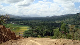
A view over Pucanganak village in western Trenggalek
-
Traditional boats are popular among tourists on Prigi beach
-
Sunset on Prigi pier
-
Skyline of Trenggalek Kota
-
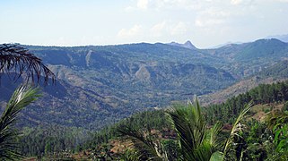
Highlands in western Trenggalek
-
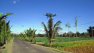
Plantations in a typical village
-
Winding road to Bendungan district in northern Trenggalek
-
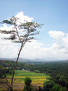
Village in Trenggalek
See also
References
- ^ Elected Regent and Vice Regent of Trenggalek for 2010-2015 period Archived 2010-12-13 at the Wayback Machine. Indonesian General Election Commission (KPU) (Indonesian)
- ^ General Situation of Trenggalek. Trenggalek Tourism Board
- ^ Badan Pusat Statistik, Jakarta, 28 February 2024, Kabupaten Trenggalek Dalam Angka 2024 (Katalog-BPS 1102001.3503)
- ^ Biro Pusat Statistik, Jakarta, 2011.
- ^ Badan Pusat Statistik, Jakarta, 2021.


