Portal:Geography
The Geography Portal

Geography (from Ancient Greek γεωγραφία geōgraphía; combining gê 'Earth' and gráphō 'write') is the study of the lands, features, inhabitants, and phenomena of Earth. Geography is an all-encompassing discipline that seeks an understanding of Earth and its human and natural complexities—not merely where objects are, but also how they have changed and come to be. While geography is specific to Earth, many concepts can be applied more broadly to other celestial bodies in the field of planetary science. Geography has been called "a bridge between natural science and social science disciplines."
Origins of many of the concepts in geography can be traced to Greek Eratosthenes of Cyrene, who may have coined the term "geographia" (c. 276 BC – c. 195/194 BC). The first recorded use of the word γεωγραφία was as the title of a book by Greek scholar Claudius Ptolemy (100 – 170 AD). This work created the so-called "Ptolemaic tradition" of geography, which included "Ptolemaic cartographic theory." However, the concepts of geography (such as cartography) date back to the earliest attempts to understand the world spatially, with the earliest example of an attempted world map dating to the 9th century BCE in ancient Babylon. The history of geography as a discipline spans cultures and millennia, being independently developed by multiple groups, and cross-pollinated by trade between these groups. The core concepts of geography consistent between all approaches are a focus on space, place, time, and scale.
Today, geography is an extremely broad discipline with multiple approaches and modalities. There have been multiple attempts to organize the discipline, including the four traditions of geography, and into branches. Techniques employed can generally be broken down into quantitative and qualitative approaches, with many studies taking mixed-methods approaches. Common techniques include cartography, remote sensing, interviews, and surveying. (Full article...)
 Featured article -
-


El Tatio geyser field
El Tatio is a geothermal field with many geysers located in the Andes Mountains of northern Chile at 4,320 metres (14,170 ft) above mean sea level. It is the third-largest geyser field in the world and the largest in the Southern Hemisphere. Various meanings have been proposed for the name "El Tatio", including "oven" or "grandfather". The geothermal field has many geysers, hot springs, and associated sinter deposits. These hot springs eventually form the Rio Salado, a major tributary of the Rio Loa, and are a major source of arsenic pollution in the river. The vents are sites of populations of extremophile microorganisms such as hyperthermophiles, and El Tatio has been studied as an analogue for the early Earth and possible past life on Mars.
El Tatio lies at the western foot of a series of stratovolcanoes, which runs along the border between Chile and Bolivia. This series of volcanoes is part of the Central Volcanic Zone, one of several volcanic belts in the Andes, and of the Altiplano–Puna volcanic complex (APVC). This is a system of large calderas and associated ignimbrites, which have been the sources of supereruptions between 10 and 1 million years ago. Some of these calderas may be the source of heat for the El Tatio geothermal system. There are no recorded eruptions of the Tatio volcanoes in the historical period. (Full article...) -
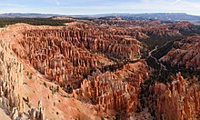
Bryce Canyon National Park (/braɪs/) is an American national park located in southwestern Utah. The major feature of the park is Bryce Canyon, which despite its name, is not a canyon, but a collection of giant natural amphitheaters along the eastern side of the Paunsaugunt Plateau. Bryce is distinctive due to geological structures called hoodoos, formed by frost weathering and stream erosion of the river and lake bed sedimentary rock. The red, orange, and white colors of the rocks provide spectacular views for park visitors. Bryce Canyon National Park is much smaller and sits at a much higher elevation than nearby Zion National Park. The rim at Bryce varies from 8,000 to 9,000 feet (2,400 to 2,700 m).
The Bryce Canyon area was settled by Mormon pioneers in the 1850s and was named after Ebenezer Bryce, who homesteaded in the area in 1874. The area was originally designated as a national monument by President Warren G. Harding in 1923 and was redesignated as a national park by Congress in 1928. The park covers 35,835 acres (55.992 sq mi; 14,502 ha; 145.02 km) and receives substantially fewer visitors than Zion National Park (nearly 4.3 million in 2016) or Grand Canyon National Park (almost 6 million in 2016), largely due to Bryce's more remote location. In 2023, Bryce Canyon received 2,461,269. (Full article...) -
The Second Silesian War (German: Zweiter Schlesischer Krieg) was a war between Prussia and Austria that lasted from 1744 to 1745 and confirmed Prussia's control of the region of Silesia (now in south-western Poland). The war was fought mainly in Silesia, Bohemia, and Upper Saxony and formed one theatre of the wider War of the Austrian Succession. It was the second of three Silesian Wars fought between Frederick the Great's Prussia and Maria Theresa's Austria in the mid-18th century, all three of which ended in Prussian control of Silesia.
The conflict has been viewed as a continuation of the First Silesian War, which had concluded only two years before. After the Treaty of Berlin ended hostilities between Austria and Prussia in 1742, the Habsburg monarchy's fortunes improved greatly in the continuing War of the Austrian Succession. As Austria expanded its alliances with the 1743 Treaty of Worms, Prussia entered a renewed alliance with Austria's enemies in the League of Frankfurt and rejoined the war, hoping to prevent a resurgent Austria from taking back Silesia. (Full article...)


Carabane, also known as Karabane, is an island and a village located in the extreme south-west of Senegal, in the mouth of the Casamance River. This relatively recent geological formation consists of a shoal and alluvium to which soil is added by accumulation in the branches and roots of the mangrove trees which cover most of the island. Along with the rest of Ziguinchor Region, Carabane has a tropical climate, cycling between a dry season and a wet season. The island was once considered an arid location where no useful plants were likely to grow, but it now supports several types of fruit tree, the most common of which are mangos and oranges. Although the nearby Basse Casamance National Park and Kalissaye Avifaunal Reserve have been closed for years because of the Casamance Conflict, Carabane has continued to attract ornithologists interested in its wide variety of birds. Various species of fish are plentiful around the island, but there are very few mammals.
The earliest known inhabitants of the island were the Jola, the ethnic group which is still the most populous on the island. The Portuguese were active in the region from the 16th century onwards; however, they did not linger on "Mosquito Island", the mosquitoes and black flies convincing them to establish their trading post in the town of Ziguinchor instead in 1645. On January 22, 1836, the island was ceded to France by the village leader of Kagnout in return for an annual payment of 196 francs. A series of treaties between the French and the leaders of the local peoples ensued; however, the inhabitants of Carabane did not recognize the authority of the treaties imposed upon them, resulting in lootings and abductions among French rice farmers by the Karoninka people. In 1869, Carabane became autonomous, but it merged with Sédhiou in 1886. Since World War II, the population of the island has gradually declined for a variety of reasons including periods of drought, the Casamance Conflict and, more recently, the sinking of the ferry Joola in 2002. Much of the village's ability to trade and receive tourists was lost until 2014, when MV Aline Sitoe Diatta resumed ferry services to the island. (Full article...)
Dom Pedro Afonso (19 July 1848 – 10 January 1850) was the Prince Imperial and heir apparent to the throne of the Empire of Brazil. Born at the Palace of São Cristóvão in Rio de Janeiro, he was the second son and youngest child of Emperor Dom Pedro II and Dona Teresa Cristina of the Two Sicilies, and thus a member of the Brazilian branch of the House of Braganza. Pedro Afonso was seen as vital to the future viability of the monarchy, which had been put in jeopardy by the death of his older brother Dom Afonso almost three years earlier.
Pedro Afonso's death from fever at the age of one devastated the Emperor, and the imperial couple had no further children. Pedro Afonso's older sister Dona Isabel became heiress, but Pedro II was unconvinced that a woman could ever be accepted as monarch by the ruling elite. He excluded Isabel from matters of state and failed to provide training for her possible role as empress. With no surviving male children, the Emperor came to understand that the imperial line was destined to end with his own death. (Full article...)
The Manchester Ship Canal is a 36 mi-long (58 km) inland waterway in the North West of England linking Manchester to the Irish Sea. Starting at the Mersey Estuary at Eastham, near Ellesmere Port, Cheshire, it generally follows the original routes of the rivers Mersey and Irwell through the historic counties of Cheshire and Lancashire. Several sets of locks lift vessels about 60 ft (18 m) to the canal's terminus in Manchester. Landmarks along its route include the Barton Swing Aqueduct, the world's only swing aqueduct, and Trafford Park, the world's first planned industrial estate and still the largest in Europe.
The rivers Mersey and Irwell were first made navigable in the early 18th century. Goods were also transported on the Runcorn extension of the Bridgewater Canal (from 1776) and the Liverpool and Manchester Railway (from 1830) but by the late 19th century the Mersey and Irwell Navigation had fallen into disrepair and was often unusable. Manchester's business community viewed the charges imposed by Liverpool's docks and the railway companies as excessive. A ship canal was proposed to give ocean-going vessels direct access to Manchester. The region was suffering from the Long Depression; the canal's proponents argued that the scheme would boost competition and create jobs. They gained public support for the scheme, which was first presented to Parliament as a bill in 1882. Faced with stiff opposition from Liverpool, the canal's supporters were unable to gain the necessary act of Parliament to allow the scheme to go ahead until 1885. (Full article...)

Resolution Guyot (formerly known as Huevo) is a guyot (tablemount) in the underwater Mid-Pacific Mountains in the Pacific Ocean. It is a circular flat mountain, rising 500 metres (1,600 ft) above the seafloor to a depth of about 1,320 metres (4,330 ft), with a 35-kilometre-wide (22 mi) summit platform. The Mid-Pacific Mountains lie west of Hawaii and northeast of the Marshall Islands, but at the time of its formation, the guyot was located in the Southern Hemisphere.
The guyot was probably formed by a hotspot in today's French Polynesia before plate tectonics shifted it to its present-day location. The Easter, Marquesas, Pitcairn and Society hotspots, among others, may have been involved in the formation of Resolution Guyot. Volcanic activity has been dated to have occurred 107–129 million years ago and formed a volcanic island that was subsequently flattened by erosion. Carbonate deposition commenced, forming an atoll-like structure and a carbonate platform. (Full article...)
Palmyra (/pælˈmaɪrə/ pal-MY-rə; Palmyrene: 𐡶𐡣𐡬𐡥𐡴 (), romanized: Tadmor; Arabic: تَدْمُر, romanized: Tadmur) is an ancient city in the eastern part of the Levant, now in the center of modern Syria. Archaeological finds date back to the Neolithic period, and documents first mention the city in the early second millennium BC. Palmyra changed hands on a number of occasions between different empires before becoming a subject of the Roman Empire in the first century AD. (Full article...)
The War of the Bavarian Succession (German: Bayerischer Erbfolgekrieg; 3 July 1778 – 13 May 1779) was a dispute between the Austrian Habsburg monarchy and an alliance of Saxony and Prussia over succession to the Electorate of Bavaria after the extinction of the Bavarian branch of the House of Wittelsbach. The Habsburgs sought to acquire Bavaria, and the alliance opposed them, favoring another branch of the Wittelsbachs. Both sides mobilized large armies, but the only fighting in the war was a few minor skirmishes. However, thousands of soldiers died from disease and starvation, earning the conflict the name Kartoffelkrieg (Potato War) in Prussia and Saxony; in Habsburg Austria, it was sometimes called the Zwetschgenrummel (Plum Fuss).
On 30 December 1777, Maximilian III Joseph, the last of the junior Wittelsbach line, died of smallpox, leaving no children. Charles Theodore, a scion of a senior branch of the House of Wittelsbach, held the closest claim of kinship, but he also had no legitimate children to succeed him. His cousin, Charles II August, Duke of Zweibrücken, therefore had a legitimate legal claim as Charles Theodore's heir presumptive. Across Bavaria's southern border, Joseph II, Holy Roman Emperor coveted the Bavarian territory and had married Maximilian Joseph's sister Maria Josepha in 1765 to strengthen any claim he could extend. His agreement with the heir, Charles Theodore, to partition the territory neglected any claims of the heir presumptive, Charles August. (Full article...)
Hajj: Journey to the Heart of Islam was an exhibition held at the British Museum in London from 26 January to 15 April 2012. It was the world's first major exhibition telling the story, visually and textually, of the hajj – the pilgrimage to Mecca which is one of the five pillars of Islam. Textiles, manuscripts, historical documents, photographs, and art works from many different countries and eras were displayed to illustrate the themes of travel to Mecca, hajj rituals, and the Kaaba. More than two hundred objects were included, drawn from forty public and private collections in a total of fourteen countries. The largest contributor was David Khalili's family trust, which lent many objects that would later be part of the Khalili Collection of Hajj and the Arts of Pilgrimage.
The exhibition was formally opened by Prince Charles in a ceremony attended by Prince Abdulaziz bin Abdullah, son of King Abdullah, the custodian of the Two Holy Mosques. It was popular both with Muslims and non-Muslims, attracting nearly 120,000 adult visitors and favourable press reviews. This success inspired the Museum of Islamic Art in Doha, the Arab World Institute in Paris, the National Museum of Ethnology in Leiden, and the Tropenmuseum in Amsterdam to stage their own hajj-themed exhibitions with contributions from the Khalili Collection. (Full article...)


.jpg)


