Loading
  • 21 Aug, 2019

  • By, Wikipedia

Portal:Oregon

Oregon (/ˈɒrɪɡən, -ɡɒn/ ORR-ih-ghən, -⁠gon) is a state in the Pacific Northwest region of the United States. Oregon is a part of the Western United States, with the Columbia River delineating much of Oregon's northern boundary with Washington, while the Snake River delineates much of its eastern boundary with Idaho. The 42° north parallel delineates the southern boundary with California and Nevada. The western boundary is formed by the Pacific Ocean.

Oregon has been home to many indigenous nations for thousands of years. The first European traders, explorers, and settlers began exploring what is now Oregon's Pacific coast in the early to mid-16th century. As early as 1564, the Spanish began sending vessels northeast from the Philippines, riding the Kuroshio Current in a sweeping circular route across the northern part of the Pacific. In 1592, Juan de Fuca undertook detailed mapping and studies of ocean currents in the Pacific Northwest, including the Oregon coast as well as the strait now bearing his name. The Lewis and Clark Expedition traversed Oregon in the early 1800s, and the first permanent European settlements in Oregon were established by fur trappers and traders. In 1843, an autonomous government was formed in the Oregon Country, and the Oregon Territory was created in 1848. Oregon became the 33rd state of the U.S. on February 14, 1859.

Today, with 4.2 million people over 98,000 square miles (250,000 km), Oregon is the ninth largest and 27th most populous U.S. state. The capital, Salem, is the third-most populous city in Oregon, with 175,535 residents. Portland, with 652,503, ranks as the 26th among U.S. cities. The Portland metropolitan area, which includes neighboring counties in Washington, is the 25th largest metro area in the nation, with a population of 2,512,859. Oregon is also one of the most geographically diverse states in the U.S., marked by volcanoes, abundant bodies of water, dense evergreen and mixed forests, as well as high deserts and semi-arid shrublands. At 11,249 feet (3,429 m), Mount Hood is the state's highest point. Oregon's only national park, Crater Lake National Park, comprises the caldera surrounding Crater Lake, the deepest lake in the United States. The state is also home to the single largest organism in the world, Armillaria ostoyae, a fungus that runs beneath 2,200 acres (8.9 km) of the Malheur National Forest. (Full article...)

Terrain of Upper and Lower Table Rock
Upper Table Rock and Lower Table Rock are two prominent volcanic plateaus located just north of the Rogue River in Jackson County, Oregon. They are approximately seven million years old. The land is jointly owned; The Nature Conservancy is responsible for 3,591 acres (14.53 km), while the Bureau of Land Management is responsible for 1,280 acres (5.2 km). An abandoned airstrip is located on Lower Table Rock, and a very high frequency omni-directional range (VOR) aviation tower is located on Upper Table Rock. The rocks are home to over 70 species of animals, 140 species of plants, and 200 species of wildflowers, in four distinct habitats. The Table Rocks have been listed as an Area of Critical Environmental Concern since 1984. They are presently one of the most popular hiking locations in the Rogue Valley, featuring two trails: the Lower Table Rock Trail and the Upper Table Rock Trail. They lead to the flat tops of the plateaus. The plateaus are named for their location along the Rogue River, not for their height. Upper Table Rock, 2,091 feet (637 m) above sea level at its highest point, is located upstream, while Lower Table Rock is farther downstream, with an elevation of 2,049 feet (625 m).

Selected biography - show another

Pre's Rock, memorial for Steve Prefontaine
Steve "Pre" Prefontaine (1951–1975) was an American Olympic runner born in Coos Bay, Oregon. Prefontaine was primarily a long distance runner, and at one point held the American record in every running event from the 2000 meters to the 10,000 meters. Prefontaine had one leg longer than the other (a common condition that does not affect running speed), and due to this he was told to give up on his dream of being the fastest runner on earth. He is considered one of the greatest American runners of all time, having inspired a running boom during the 1970s. He is known for his extremely aggressive "front-running" racing style and always believing in giving a full effort. Prefontaine died at the age of 24 in a car accident. Prefontaine set 19 National High School track records. Following high school, Prefontaine enrolled at the University of Oregon in order to continue his running under coach Bill Bowerman, who would later co-found Blue Ribbon Sports, the precursor to the Nike shoe company. After his freshman year, in which he finished 3rd in the NCAA National Cross Country meet, he suffered only two more defeats in college (both in the mile), winning three Division I NCAA Cross Country championships and four straight three-mile titles in Track and Field.He set the American record in the 5000 meter race, the event that took him to the 1972 Summer Olympic Games in Munich where he finished fourth.

In this month

<< Previous month Next month >>

More did you know - load new batch

Rogue River Ranch

Did you know (auto-generated) - load new batch

General images - load new batch

The following are images from various Oregon-related articles on Wikipedia.

Selected image - show another

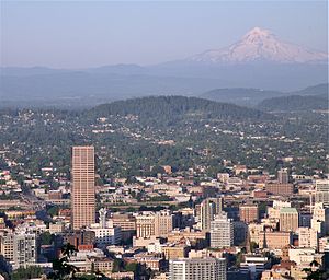
Mount Tabor
Mount Tabor
Credit: Cacophony

Mount Tabor is in the center with Mount Hood in the distance. Downtown Portland is in the foreground, and the tall building on the left is the US Bancorp Tower. Mount Tabor is an extinct volcanic cinder cone in the Boring Lava Field. It is the site of a large city park, and the central feature of a Portland neighborhood of the same name. The name derives from Mount Tabor, Israel.

Selected quote - show another

Other great rivers add power to you
Yakima, Snake, and the Klickitat, too
Sandy, Willamette and Hood River too
So roll on, Columbia, roll on

Selected panorama - show another

Pillars of Rome
Pillars of Rome
Credit: Cacophony
Pillars of Rome, a unique feature in the southeast corner of Oregon.

Main topics

Featured content

Extended content
See also: Good articles relating to Oregon

Featured articles

Featured lists

Good articles

Featured pictures

Featured portals

Picture of the day pictures

Featured topics

Subcategories

Category puzzle
Category puzzle
Select [►] to view subcategories

List articles

Culture

Education

Economy

Geography

Government

History

Law

Media

Natural history

Lighthouse of Cape Meares, Oregon

People

Protected areas

Transportation

State facts

State symbols:

American beaver
Western meadowlark
Chinook salmon
Oregon grape
Oregon Swallowtail butterfly
Douglas fir
Metasequoia
Sunstone
Thunderegg

Related portals

WikiProjects

Things you can do

Extended content
This month's Collaboration of the Month projects: Women's History Month: Create or improve articles for women listed at Oregon Women of Achievement (modern) or Women of the West, Oregon chapter (historical)
Portland, Oregon, in 1898 (Featured picture candidate)

Associated Wikimedia

The following Wikimedia Foundation sister projects provide more on this subject:

More portals

Purge server cache

44°00′N 120°30′W / 44°N 120.5°W / 44; -120.5