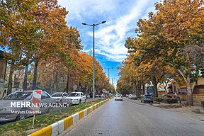
Bojnurd
History
According to local tradition, the whole area was controlled by the Qarai Turks since the Mongol invasion in the 13th century.
Bojnurd is of recent origin and possibly built by the Safavids for the Kurdish Şadiyan tribe who had been settled there to strengthen the Safavid borders against hostile Turkmens. Traditionally, the city was surrounded by a defensive wall and consisted of eleven quarters, bazaars and four mosques.
In 1849, the city saw a revolt which destroyed the city. When traveller G. C. Napier visited the city in 1876, it was noted that the chief of Bojnurd was a Kurd who governed the city without taxation in exchange for military support to the central government in Tehran.
Severe earthquakes in 1896 and 1929 destroyed the city and its surroundings. The city would consequently be rebuilt without historical or recent fortifications in a modern matter. In 1997, a magnitude 6.5 earthquake caused significant damage and many fatalities in the city.
Demographics
Population
At the time of the 2006 National Census, the city's population was 172,772 in 44,217 households. The following census in 2011 counted 199,791 people in 56,761 households. The 2016 census measured the population of the city as 228,931 people in 67,335 households.
ٔGeography
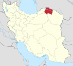
Bojnourd city, the capital of North Khorasan province with an area of 36 square kilometers, is located in northeastern Iran at 57 degrees and 20 minutes longitude and 37 degrees and 28 minutes latitude south of Kopedagh mountain range and east of Aladagh mountain range and north of Alborz mountain range. Bojnourd is 1070 meters above sea level and its distance to Tehran is 821 kilometers.
Climate
Bojnord has a cold semi-arid climate (BSk) according to the Köppen climate classification.
| Climate data for Bojnurd (1991–2020) | |||||||||||||
|---|---|---|---|---|---|---|---|---|---|---|---|---|---|
| Month | Jan | Feb | Mar | Apr | May | Jun | Jul | Aug | Sep | Oct | Nov | Dec | Year |
| Record high °C (°F) | 19.2 (66.6) |
27.2 (81.0) |
30.8 (87.4) |
34.4 (93.9) |
37.4 (99.3) |
40.0 (104.0) |
41.2 (106.2) |
40.6 (105.1) |
39.0 (102.2) |
33.6 (92.5) |
27.8 (82.0) |
25.0 (77.0) |
41.2 (106.2) |
| Mean daily maximum °C (°F) | 6.9 (44.4) |
8.7 (47.7) |
13.9 (57.0) |
19.9 (67.8) |
24.9 (76.8) |
30.3 (86.5) |
32.8 (91.0) |
32.1 (89.8) |
28.2 (82.8) |
21.8 (71.2) |
13.9 (57.0) |
8.8 (47.8) |
20.2 (68.3) |
| Daily mean °C (°F) | 0.9 (33.6) |
2.4 (36.3) |
7.0 (44.6) |
12.6 (54.7) |
17.8 (64.0) |
22.9 (73.2) |
25.4 (77.7) |
24.4 (75.9) |
20.2 (68.4) |
13.8 (56.8) |
7.0 (44.6) |
2.7 (36.9) |
13.1 (55.6) |
| Mean daily minimum °C (°F) | −3.7 (25.3) |
−2.4 (27.7) |
1.7 (35.1) |
6.6 (43.9) |
11.2 (52.2) |
15.5 (59.9) |
18.2 (64.8) |
16.7 (62.1) |
12.8 (55.0) |
6.9 (44.4) |
1.8 (35.2) |
−1.9 (28.6) |
7.0 (44.5) |
| Record low °C (°F) | −19.0 (−2.2) |
−21.0 (−5.8) |
−13.6 (7.5) |
−5.4 (22.3) |
−0.2 (31.6) |
4.0 (39.2) |
10.0 (50.0) |
5.4 (41.7) |
1.6 (34.9) |
−5.0 (23.0) |
−14.4 (6.1) |
−18.1 (−0.6) |
−21.0 (−5.8) |
| Average precipitation mm (inches) | 22.2 (0.87) |
31.9 (1.26) |
45.3 (1.78) |
38.7 (1.52) |
30.4 (1.20) |
10.2 (0.40) |
6.8 (0.27) |
4.8 (0.19) |
7.7 (0.30) |
12.4 (0.49) |
25.8 (1.02) |
19.2 (0.76) |
255.4 (10.06) |
| Average precipitation days (≥ 1.0 mm) | 5.4 | 6.3 | 7.4 | 6.1 | 4.9 | 1.9 | 1.1 | 0.7 | 1 | 2.8 | 4.5 | 4.5 | 46.6 |
| Average rainy days | 4 | 5.5 | 9.2 | 9.6 | 7.9 | 2.9 | 2.1 | 1.1 | 1.9 | 4.5 | 7.4 | 5.9 | 62 |
| Average snowy days | 7.2 | 7.5 | 4.7 | 0.6 | 0 | 0 | 0 | 0 | 0 | 0 | 1.2 | 4.1 | 25.3 |
| Average relative humidity (%) | 72 | 71 | 68 | 64 | 58 | 47 | 45 | 42 | 48 | 57 | 69 | 73 | 59.5 |
| Average dew point °C (°F) | −4.1 (24.6) |
−3.0 (26.6) |
0.5 (32.9) |
4.9 (40.8) |
8.1 (46.6) |
9.1 (48.4) |
11.0 (51.8) |
8.8 (47.8) |
7.2 (45.0) |
4.0 (39.2) |
0.8 (33.4) |
−2.3 (27.9) |
3.8 (38.7) |
| Mean monthly sunshine hours | 152 | 152 | 174 | 211 | 272 | 325 | 342 | 342 | 289 | 248 | 175 | 144 | 2,826 |
| Source: NOAA (Snow and Sleet days 1981–2010) | |||||||||||||
| Climate data for Bojnurd (1977–2010) | |||||||||||||
|---|---|---|---|---|---|---|---|---|---|---|---|---|---|
| Month | Jan | Feb | Mar | Apr | May | Jun | Jul | Aug | Sep | Oct | Nov | Dec | Year |
| Mean daily maximum °C (°F) | 6.2 (43.2) |
7.8 (46.0) |
13.0 (55.4) |
19.8 (67.6) |
24.3 (75.7) |
29.8 (85.6) |
32.5 (90.5) |
31.9 (89.4) |
28.2 (82.8) |
21.4 (70.5) |
14.3 (57.7) |
8.6 (47.5) |
19.8 (67.7) |
| Daily mean °C (°F) | 1.2 (34.2) |
2.6 (36.7) |
7.2 (45.0) |
13.3 (55.9) |
17.6 (63.7) |
22.5 (72.5) |
25.2 (77.4) |
24.3 (75.7) |
20.3 (68.5) |
14.1 (57.4) |
8.3 (46.9) |
3.6 (38.5) |
13.4 (56.0) |
| Mean daily minimum °C (°F) | −3.7 (25.3) |
−2.6 (27.3) |
1.4 (34.5) |
6.7 (44.1) |
10.9 (51.6) |
15.2 (59.4) |
17.9 (64.2) |
16.6 (61.9) |
12.5 (54.5) |
6.9 (44.4) |
2.2 (36.0) |
−1.5 (29.3) |
6.9 (44.4) |
| Average precipitation mm (inches) | 25.1 (0.99) |
32.2 (1.27) |
42.9 (1.69) |
39.1 (1.54) |
33.3 (1.31) |
9.0 (0.35) |
8.7 (0.34) |
5.5 (0.22) |
9.3 (0.37) |
12.4 (0.49) |
26.0 (1.02) |
24.3 (0.96) |
267.8 (10.55) |
| Average precipitation days | 10.6 | 11.4 | 12.4 | 10.8 | 9.8 | 3.8 | 2.4 | 1.9 | 2.8 | 5.3 | 8.1 | 9.9 | 89.2 |
| Average relative humidity (%) | 72 | 71 | 68 | 63 | 58 | 48 | 46 | 43 | 48 | 57 | 67 | 72 | 59 |
| Mean monthly sunshine hours | 144.4 | 148.6 | 164.7 | 206.8 | 267.1 | 309.0 | 328.5 | 331.3 | 281.1 | 243.2 | 178.1 | 142.3 | 2,745.1 |
| Source 1: World Meteorological Organisation | |||||||||||||
| Source 2: [1] | |||||||||||||
- ^ Rainy days calculated using parameter codes 46 and 71
Colleges and universities
Universities located in Bojnord include:
- University of Bojnurd
- North Khorasan University of Medical Sciences
- Islamic Azad University of Bojnurd
- Eshragh Institute of Higher Education (Bojnurd, North Khorasan)
- Payam Noor University of Bojnurd
- University of Kosar
Notable people

- Abdolhossein Teymourtash (Sardar Moazzam Khorasani), a distinguished and influential politician of the 20th century (Pahlavi dynasty)
- Ali-Akbar Davar, politician and judge and the founder of the modern judicial system of Iran
- Kazem Mousavi Bojnurdi, historian, theologian, writer and the curator of the National Library of Iran (1997–2005)
- Mohammad Davari, journalist, known for arrest in 2009–10 Iranian election protests
- Mostafa Tabrizi, politician
 |
 |
 |
See also
![]() Media related to Bojnord at Wikimedia Commons
Media related to Bojnord at Wikimedia Commons
Notes
References
- ^ OpenStreetMap contributors (26 October 2024). "Bojnord, Bojnord County" (Map). OpenStreetMap (in Persian). Retrieved 26 October 2024.
- ^ Census of the Islamic Republic of Iran, 1395 (2016): North Khorasan Province. amar.org.ir (Report) (in Persian). The Statistical Center of Iran. Archived from the original (Excel) on 27 October 2020. Retrieved 19 December 2022.
- ^ "Maps, Weather, and Airports for Bojnurd, Iran".
- ^ Bojnord can be found at GEOnet Names Server, at this link, by opening the Advanced Search box, entering "-3056548" in the "Unique Feature Id" form, and clicking on "Search Database".
- ^ Habibi, Hassan (c. 2015) [Approved 21 June 1369]. Approval of the organization and chain of citizenship of the elements and units of the divisions of Khorasan province, centered in Mashhad. rc.majlis.ir (Report) (in Persian). Ministry of the Interior, Defense Political Commission of the Government Council. Proposal 3223.1.5.53; Approval Letter 3808-907; Notification 84902/T125K. Archived from the original on 17 November 2015. Retrieved 6 January 2024 – via Islamic Parliament Research Center.
- ^ "Tehran".
- ^ "Distance from Bojnurd to Mashhad". www.distancecalculator.net. Retrieved 23 June 2022.
- ^ Ehlers, Eckart; Bosworth, C. E. (1989). "BOJNŪRD". Encyclopedia Iranica. IV.
- ^ "Earthquake Toll Rises in Iran as Aftershocks Hit". Reuters. Tehran, Iran: ReliefWeb. 5 February 1997. Retrieved 10 March 2022.
- ^ Census of the Islamic Republic of Iran, 1385 (2006): North Khorasan Province. amar.org.ir (Report) (in Persian). The Statistical Center of Iran. Archived from the original (Excel) on 20 September 2011. Retrieved 25 September 2022.
- ^ Census of the Islamic Republic of Iran, 1390 (2011): North Khorasan Province. irandataportal.syr.edu (Report) (in Persian). The Statistical Center of Iran. Archived from the original (Excel) on 19 January 2023. Retrieved 19 December 2022 – via Iran Data Portal, Syracuse University.
- ^ "Bojnord". www.visitiran.ir. Retrieved 5 June 2022.
- ^ "Köppen Climate Classification: How to Use the Other Plant Map". Lawnstarter. 22 October 2019. Retrieved 23 June 2022.
- ^ "World Meteorological Organization Climate Normals for 1991-2020: Bojnurd-40723" (CSV). ncei.noaa.gov (Excel). National Oceanic and Atmosoheric Administration. Retrieved 18 February 2024.
- ^ "World Meteorological Organization Climate Normals for 1981-2010: Bojnurd(WMO number: 40723)" (XLS). ncei.noaa.gov (Excel). National Oceanic and Atmosoheric Administration. Retrieved 18 February 2024.
Parameter Code 80: Number of Days with Sleet/Snow
- ^ "دانستنیهایی از استان خراسان شمالی".
External links
